Kananaskis River facts for kids
Quick facts for kids Kananaskis River |
|
|---|---|

Kananaskis River
|
|
| Country | Canada |
| Province | Alberta |
| Physical characteristics | |
| Main source | Peter Lougheed Provincial Park 2,720 meters (8,920 ft) 50°43′41″N 115°17′04″W / 50.72803°N 115.28457°W |
| River mouth | Bow River 1,315 meters (4,314 ft) 51°05′41″N 115°03′43″W / 51.09465°N 115.06190°W |
| Length | 74 kilometers (46 mi) |
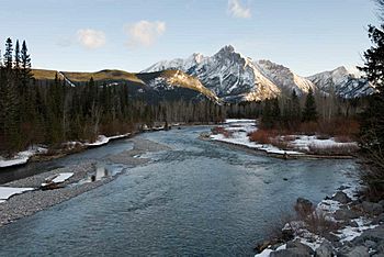
The Kananaskis River is a beautiful mountain river located in western Alberta, Canada. It flows through a large area called Kananaskis Country and eventually joins the Bow River. The river got its name in 1858 from John Palliser, who named it after a Cree person.
Contents
Where the Kananaskis River Flows
The Kananaskis River starts high up in the Canadian Rockies. Its journey begins in Peter Lougheed Provincial Park, east of the continental divide.
First, it flows southeast into the Upper Kananaskis Lake. Then, it turns north and enters the Lower Kananaskis Lake. From there, it continues flowing north. It runs along the edge of Spray Valley Provincial Park and Elbow-Sheep Wildland Provincial Park. The Kananaskis Trail road follows the river's path here.
Further downstream, the river flows through Bow Valley Provincial Park. Here, it forms a lake called Barrier Lake. This lake is man-made and is used to create hydroelectric power. This means it helps make electricity using the force of the water.
The Kananaskis River finally meets the Bow River near a place called Seebe. This is about 30 kilometers (19 miles) east of Canmore. The Kananaskis River is about 74 kilometers (46 mi) long in total.
Three dams were built on the river in 1955. These dams, named Interlakes, Pocaterra, and Barrier, control how fast the river flows. They are operated by a company called TransAlta.
Fun Activities on the Kananaskis River
The Kananaskis River is a great place for outdoor adventures! Many hiking trails can be found along the upper parts of the river.
If you love water sports, the lower part of the Kananaskis River is very popular. People enjoy canoeing, kayaking, and rafting here. Many tours start from nearby towns like Canmore or Banff.
Exploring the Lower Kananaskis River for Water Sports
For people who enjoy exciting whitewater, the Lower Kananaskis River is a favorite spot. It has friendly Class II (and sometimes Class III) whitewater rapids. Because dams control the river, the water levels are usually easy to predict. TransAlta, the company that runs the dams, often shares information about when they will release water and how fast it will flow on their website.
The Canoe Meadows area is famous for the Kananaskis Whitewater Festival (also called "Kanfest"). This is an annual festival that usually happens in mid-August. It brings together kayakers of all skill levels for a fun weekend of water activities.
The Upper Kananaskis River (the part upstream from Barrier Lake) is not as good for paddling. It often has low water levels and many obstacles like fallen trees.
Starting and Ending Your River Trip
- To start your trip on the Lower Kananaskis, you can put in at the parking lot for the "Widow Maker" Rapid. This spot is about 1 kilometer (0.6 miles) upstream from the Kananaskis Information Centre.
- To finish your trip, you can take out at Canoe Meadows Campground. This is about 1 kilometer (0.6 miles) downstream from the Kananaskis Information Centre.
Exciting Rapids and Features
The first big rapid on the Kananaskis is called the Widow Maker. It's a Class III "pool drop" rapid, which means the water drops into a calm pool. It can be a bit tricky! If you want to avoid it, you can easily start your trip just below this rapid.
The river has many fun features created by people. One of the first "play features" is a small "hole" on the left side of the river called Hollywood. The river then winds along with man-made calm spots (called eddies) on both sides.
Next, you'll find a feature called Point-Break. This is considered the best "hole" on the river for "playboating," which is when kayakers do tricks in one spot. Downstream from there is the river's biggest wave, called Santa Claus. About 30 yards (27 meters) below it is another strong "hole" called "Santa's Little Helper."
The section finishes near Canoe Meadows Campground. Here, you'll find a large "V" shaped wave that's popular for river surfing. There's also another wave called the Green Tongue and a well-designed slalom course. Many of the rapids and features on this part of the river were created or changed by placing large boulders. You can exit the river anywhere on the right side after the last slalom gate to get back to the take-out spot.
In June 2013, a major flood hit the area. This flood caused a lot of damage to the man-made rapids on the lower Kananaskis River. Many of them are not as good for playboating anymore. This is partly because the boulders moved and partly because the water levels are not always the same. Soon after the flood, the Alberta Whitewater Association rebuilt a temporary slalom course. They plan to make it even better when they have more time and money.
See also
 In Spanish: Río Kananaskis para niños
 | Aurelia Browder |
 | Nannie Helen Burroughs |
 | Michelle Alexander |

