
Ghost River (Alberta) facts for kids
Quick facts for kids Ghost River |
|
|---|---|

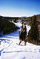
Mount Aylmer with the North Ghost in the foreground
|
|
| Country | Canada |
| Province | Alberta |
| Physical characteristics | |
| Main source | South slopes of Mount Oliver 51°24′38″N 115°29′20″W / 51.41056°N 115.48889°W |
| River mouth | Bow River at Ghost Lake 51°15′40″N 114°45′50″W / 51.26111°N 114.76389°W |
| Basin features | |
| Basin size | 911 km2 (352 sq mi) |
| Tributaries |
|
The Ghost River is a river found in Alberta, Canada. It starts high up in the Rocky Mountains. The river then flows into the Bow River at Ghost Lake. From there, its waters travel through cities like Cochrane and Calgary. Eventually, these waters reach Hudson Bay. The upper parts of the Ghost River are protected in the Ghost River Wilderness Area.
The name Ghost comes from old First Nations stories. These legends tell of a big battle between the Stoney and Blackfoot peoples. This fight happened where the Ghost River meets the Bow River. People believed the spirits of those who died in the battle haunted the area. This led to the name Ghost River. Before this, the Palliser Expedition in 1860 called it Deadman's River.
Contents
Where Does the Ghost River Flow?
The Ghost River actually starts as two separate streams. These are called the North Ghost and South Ghost. The North Ghost is the longer of the two. It begins on the southern side of Mount Oliver in the Front Ranges.
The North Ghost generally flows towards the east. It then meets the South Ghost. After this, the river passes through small communities like Waiparous and Benchlands. It then enters a deep canyon. Finally, it joins the Bow at Ghost Lake. The Bow River then connects to the South Saskatchewan River. This river eventually flows into Hudson Bay through the Nelson River.
There is a dam at Ghost Lake that helps make electricity. But there are no other big power projects directly on the Ghost River itself. In the past, some water from the North Ghost was sent to Lake Minnewanka. This helped add more water to the lake. However, a big flood in 2013 damaged the dam that did this. Now, the dam no longer works.
A Look Back: History of the Ghost River Area

People have lived in the Ghost River area for hundreds of years. The Assiniboia people were among the first to live here. In 1877, a special agreement called Treaty 7 was signed. This agreement gave the Iyhe Nakoda people reserve lands in their traditional hunting areas. Today, they have reserve lands near Morley. These lands stretch from the Bow Valley up to the Ghost River.
Early European explorers also visited this area. David Thompson camped near where the Bow and Ghost rivers meet in 1800. James Hector explored the Ghost River area between 1858 and 1860. He studied the rocks and land formations.
The first lasting settlement in the area was the Morleyville mission. Missionary George McDougall started it in 1873. More people came to the area when the CPR train tracks were built in the 1880s. This also helped ranching grow. The two main communities along the Ghost River are Benchlands and Waiparous. Benchlands became a hamlet in 1978, and Waiparous became a summer village in 1986.
Ranger stations and fire lookouts were built in the late 1800s and early 1900s. One was on top of Black Rock Mountain. The Aura Ranger Station helped the area from 1917 until the 1960s. It was then left empty and burned down. The last full-time ranger station in the Ghost area closed in 1996. However, a small fire base still exists near the old Aura Station on Highway 40.
In September 2020, a large wildfire started in the North Ghost area. It burned between Devil's Head and Black Rock Mountain. Investigators found that the fire began from an abandoned campfire. The fire grew very large in early October. It even caused alerts for people in Waiparous and Benchlands to be ready to leave. Luckily, the fire is now under control.
Protecting the Ghost River: Conservation Efforts
The highest parts of the North Ghost River are protected. This area is called the Ghost River Wilderness Area. It was created in 1967 and covers about 59.14 sq mi (153.2 km2). In Wilderness Areas, no building or development is allowed. Only walking is permitted; vehicles and horses are not.
Below this protected area, the river flows through the Ghost Public Land Use Zone (PLUZ). This zone was set up in 2006. It covers about 1,500 km2 (580 sq mi). The PLUZ helps manage how people use the land for fun activities. It also tries to prevent problems with other important natural resources. One big concern was the many off-highway vehicles (OHVs) used in the area. There were not enough rules about where they could go.
There are still concerns about OHV use in the Ghost PLUZ. In 2011, studies found a lot of dirt and mud in the river. This made the water quality worse. It was directly linked to OHV use in the area. However, most other signs of environmental health are good. This includes air quality, how water runs off the land, and the health of plants near the river.
Fun Things to Do: Recreation in the Ghost River Area
The Ghost River area, especially the Ghost Public Land Use Zone, offers many fun activities. You can go hiking, scrambling (a mix of hiking and climbing), climbing, and ice climbing. Camping and hunting are also popular. The rock and ice climbing along the North Ghost are very famous. Many people think it's one of the best places in Canada for these sports. You can also camp anywhere in the PLUZ. This is different from provincial and national parks in Alberta, where you must use designated campsites.
Popular hikes and scrambles include Leseur Ridge, Black Rock Mountain, Bastion Ridge, and Orient Point. For more challenging climbs, people go to Devil's Head and Phantom Crag. Many of the best hiking and climbing spots are at the start of the Ghost River. To reach them, you often need a strong vehicle with four-wheel drive. This is because the roads were badly damaged in 2013.

Images for kids
-
Ghost River in winter

