
Waputik Range facts for kids
Quick facts for kids Waputik Range |
|
|---|---|
.JPG)
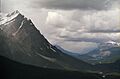
Waputik Range seen from the Icefields Parkway
|
|
| Highest point | |
| Peak | Mount Balfour |
| Elevation | 3,284 m (10,774 ft) |
| Dimensions | |
| Length | 19 km (12 mi) |
| Width | 19 km (12 mi) |
| Area | 235 km2 (91 sq mi) |
| Geography | |

Location in Alberta
|
|
| Country | Canada |
| Province | Alberta |
| Range coordinates | 51°31′59″N 116°22′02″W / 51.53306°N 116.36722°W |
| Parent range | Waputik Mountains |
The Waputik Range is a group of mountains located in the amazing Canadian Rockies. You can find it west of the upper Bow Valley, east of Bath Creek, and south of Balfour Creek. The name "Waputik" comes from the Stoney language, and it means "white goat." This mountain range was named by George Mercer Dawson, who worked for the Geological Survey of Canada. Inside the Waputik Range, you'll also find another smaller group of mountains called the President Range.
It's easy to get the Waputik Range mixed up with the much larger Waputik Mountains. The Waputik Mountains are a bigger area that includes the Waputik Range and many other peaks. These other peaks are located along the Continental Divide of the Americas, which is like a giant line that separates rivers flowing to different oceans. Much of this larger area is found within Yoho National Park.
Exploring the Peaks of Waputik Range
The Waputik Range is home to many tall and impressive mountains. Here are some of the most well-known peaks you can find in this area, listed from highest to lowest:
- Howse Peak 3295 meters (10,810 feet), which is the tallest mountain in the larger Waputik Mountains area.
- Mount Balfour 3284 meters
- Mount Patterson 3191 meters
- Mount Baker 3180 meters
- Mont des Poilus 3166 meters
- Mount Gordon 3161 meters
- The President 3123 meters
- Caldron Peak 2909 meters
- Wapta Mountain 2782 meters
- Waputik Peak 2755 meters
- Pulpit Peak 2720 meters
Images for kids
-
Waputik Range

