Mont des Poilus facts for kids
Quick facts for kids Mont des Poilus |
|
|---|---|

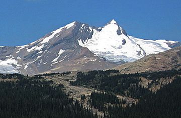
Mont des Poilus seen from Yoho Valley
|
|
| Highest point | |
| Elevation | 3,166 m (10,387 ft) |
| Prominence | 466 m (1,529 ft) |
| Parent peak | Mount Baker (3180 m) |
| Listing | Mountains of British Columbia |
| Geography | |
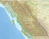
| Location | British Columbia, Canada |
| Parent range | Waputik Mountains Canadian Rockies |
| Topo map | NTS 82N/10 |
| Geology | |
| Age of rock | Cambrian |
| Type of rock | sedimentary rock |
| Climbing | |
| First ascent | 1901 James Outram, Edward Whymper, guided by C. Kaufmann, C. Klucker and J. Pollinger |
Mont des Poilus is a tall mountain in British Columbia, Canada. It stands 3,166-metre (10,387-foot) high. This mountain is found in Yoho National Park, which is part of the Canadian Rockies. The closest higher mountain is Mount Baker, about 8.0 km (5.0 mi) north. Both mountains are part of the Waputik Mountains range.
Contents
The Mountain's History
How Mont des Poilus Got Its Name
The name of Mont des Poilus was given by Arthur Oliver Wheeler. He named it just one week after World War I ended. The name "Poilu" means "hairy one" and was a nickname for the common soldiers of the French Army during the war. It was a way to honor their bravery.
First Climbers to Reach the Top
The first time anyone climbed Mont des Poilus was in 1901. The climbers were James Outram and Edward Whymper. They had help from experienced mountain guides: C. Kaufmann, C. Klucker, and J. Pollinger.
Official Recognition of the Name
The mountain's name became official in 1924. This happened after the Geographical Names Board of Canada approved it.
How Mont des Poilus Formed
Rocks and Age of the Mountain
Mont des Poilus is made of sedimentary rock. This type of rock forms from layers of sand, mud, and other materials that settle over time. These rocks were laid down during the Cambrian period, which was a very long time ago.
Mountain Building and Glaciers
The sedimentary rock formed in shallow seas. Later, huge forces pushed these rocks eastward. This event, called the Laramide orogeny, caused the rocks to fold and rise, creating the mountain. A large ice formation called the Glacier des Poilus sits on the east side of the peak. This glacier is part of the bigger Waputik Icefield, a large area covered by ice.
Weather and Climate
Understanding the Mountain's Climate
Mont des Poilus is in a subarctic climate zone. This means it has very cold, snowy winters. The summers are usually mild. Temperatures can drop below −20 °C (which is −4 °F). With the wind chill, it can feel even colder, sometimes below −30 °C (−22 °F).
Water Flow from the Mountain
Rain and melting snow from Mont des Poilus flow into nearby rivers. This water, called runoff, goes into the Yoho River and the Amiskwi River. Both of these rivers then flow into the Kicking Horse River.
 | William M. Jackson |
 | Juan E. Gilbert |
 | Neil deGrasse Tyson |


