
Howse Peak facts for kids
Quick facts for kids Howse Peak |
|
|---|---|
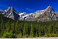
%26_Mt_Chephren_(3307m)_(7897964306).jpg)
Howse Peak (left) & Mt Chephren (right)
|
|
| Highest point | |
| Elevation | 3,295 m (10,810 ft) |
| Prominence | 1,227 m (4,026 ft) |
| Parent peak | Mount Hector (3394 m) |
| Listing | Mountains of Alberta Mountains of British Columbia |
| Geography | |

Howse Peak
Location in British Columbia

Howse Peak
Location in Alberta
|
|
| Location | Alberta/British Columbia, Canada |
| Parent range | Waputik Mountains |
| Topo map | NTS 082N15 |
| Climbing | |
| First ascent | 1902 by J. Norman Collie, H.E.M. Stutfield, G.M. Weed, H. Woolley, guided by Hans Kaufmann |

Howse Peak is a very tall mountain in the Waputik Mountains. These mountains are part of the larger Canadian Rockies range. Howse Peak is located about 5 kilometres (3 miles) west of the Icefields Parkway. You can see it above Chephren Lake. It sits right on the continental divide, which is the line that separates Alberta and British Columbia.
Standing at 3,295 metres (10,810 feet) tall, Howse Peak is one of the highest mountains in both Alberta and British Columbia. Its name comes from Howse Pass, a mountain pass about 5 kilometres (3 miles) to its west. The pass was named by David Thompson. He named it after Joseph Howse, a trader from the Hudson's Bay Company who crossed the pass in 1809. Interestingly, Thompson himself had crossed the pass two years earlier!
Contents
Climbing Howse Peak
Howse Peak is a truly impressive mountain. It rises more than 1,600 metres (5,200 feet) above the Mistaya River to the east and Howse Pass to the west. This makes it a very challenging climb for adventurers.
The easiest way to climb Howse Peak involves a long 25-kilometre (16-mile) hike. You first walk along the Howse River. Then, you climb up a glacier on the mountain's west side. There are also some very difficult climbing paths on the east side of the mountain. These are only for expert climbers.
The First Ascent
The first time anyone successfully climbed Howse Peak was on August 14, 1902. A group of explorers made the climb: J. Norman Collie, Hugh Stutfield, G.M. Weed, and Herman Woolley. They were guided by Hans Kaufmann.
They started their climb from a camp at the base of the peak. Their journey began with a tough two-hour walk through thick woods. After that, they moved onto a rocky ridge that led towards the top. However, they soon faced two very steep rock faces along the ridge. The first one was not too hard to get past. But the second one was a much bigger challenge!
Kaufmann and Woolley managed to climb down a 50-foot (15-metre) straight-down rock chimney. The rest of the group decided to go down into the valley instead. They then found another way to get back onto the ridge further along. After a long climb through snow, avoiding some deep cracks called crevasses, they reached the summit. It took them eight hours from where they started.
Collie described the very top of the mountain as having a huge snow cornice. This is an overhang of snow that sticks out from the ridge. It hung over the very steep cliffs on the western side of Bear Creek.
How Howse Peak Was Formed
Like other mountains in Banff National Park, Howse Peak is made of different kinds of rock. It has black limestone and yellow sedimentary rock. These rocks were formed a very long time ago, from the Precambrian to the Jurassic periods.
These rocks were laid down in shallow seas. Over millions of years, they were pushed up and over younger rocks. This happened during a major mountain-building event called the Laramide orogeny.
Weather Around Howse Peak

Howse Peak is in a subarctic climate zone. This means it has very cold, snowy winters. The summers are usually mild. Temperatures can drop below −20 °C (−4 °F). With the wind, it can feel even colder, sometimes below −30 °C (−22 °F).
The snow and ice that melt from Howse Peak flow into several rivers. These include the Mistaya River, the Howse River, and the Blaeberry River.
Images for kids
-
Howse Peak (left) & Mt Chephren (right)
-
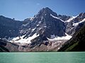
Howse Peak above Chephren Lake
-
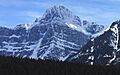
Howse Peak in the snow
