President Range facts for kids
Quick facts for kids President Range |
|
|---|---|

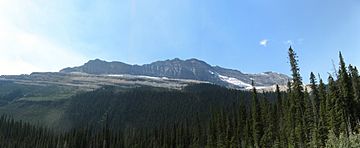
The President Range in Yoho National Park
|
|
| Highest point | |
| Peak | The President |
| Elevation | 3,138 m (10,295 ft) |
| Dimensions | |
| Area | 120 km2 (46 sq mi) |
| Geography | |
| Country | Canada |
| State/Province | British Columbia |
| Parent range | Canadian Rockies |
The President Range is a group of tall mountains in the Canadian Rockies. You can find it in the northwest part of Yoho National Park in British Columbia, Canada. This mountain range gets its name from its highest peak, a mountain called The President.
Exploring the President Range
The President Range is a beautiful part of the Canadian Rockies. It is known for its stunning views and challenging climbs. Many people visit this area to hike, explore, and enjoy nature. The range is located entirely within Yoho National Park. This helps protect its natural beauty and wildlife for everyone to enjoy.
Notable Peaks of the President Range
Here are some of the important mountains and peaks you can find in the President Range:
| Mountain/Peak | metres | feet |
|---|---|---|
| The President | 3,138 | 10,296 |
| The Vice President | 3,066 | 10,060 |
| Mount Carnarvon | 3,046 | 9,993 |
| Emerald Peak | 2,701 | 8,862 |
| Michael Peak | 2,696 | 8,844 |
| Mount Field | 2,623 | 8,671 |
Black History Month on Kiddle
African-American Women you should know
 | Anna J. Cooper |
 | Mary McLeod Bethune |
 | Lillie Mae Bradford |

All content from Kiddle encyclopedia articles (including the article images and facts) can be freely used under Attribution-ShareAlike license, unless stated otherwise. Cite this article:
President Range Facts for Kids. Kiddle Encyclopedia.
