
Michael Peak facts for kids
Quick facts for kids Michael Peak |
|
|---|---|

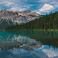
Michael Peak seen from Emerald Lake
|
|
| Highest point | |
| Elevation | 2,701 m (8,862 ft) |
| Prominence | 56 m (184 ft) |
| Parent peak | The President (3123 m) |
| Geography | |

Michael Peak
Location in British Columbia

Michael Peak
Location in Canada
|
|
| Location | British Columbia, Canada |
| Parent range | President Range Canadian Rockies |
| Topo map | NTS 82N07 |
| Geology | |
| Age of rock | Cambrian |
| Type of rock | sedimentary rock |
| Climbing | |
| First ascent | 1900 James Outram, Christian Kaufmann. |
| Easiest route | Mountaineering |
Michael Peak is a tall mountain in Yoho National Park, British Columbia, Canada. It stands about 2,701 meters (8,862 feet) high. This peak is part of the President Range, which is a smaller group within the larger Waputik Mountains.
The closest higher mountain to Michael Peak is The President. It is about 4 kilometers (2.5 miles) away to the west-northwest. Michael Peak is easy to spot from Emerald Lake, which is about 4.5 kilometers (2.8 miles) to its south. It is also near Takakkaw Falls and the town of Field, British Columbia.
Contents
The Story of Michael Peak's Name

Michael Peak was first called Angle Peak. But in 1901, a famous climber named Edward Whymper decided to rename it. He named it after his friend, Arthur Michael (1853–1942). Arthur Michael was a professor who studied organic chemistry.
Arthur Michael was also an experienced climber. In 1897, he was one of the first people to climb Mount Lefroy and Mount Victoria. He did these climbs with J. Norman Collie, who was also a chemistry professor. The name "Michael Peak" was officially accepted in 1924 by the Geographical Names Board of Canada.
First Climbers to Reach the Top
The very first time someone climbed Michael Peak was in 1900. The climbers were James Outram and his guide, Christian Kaufmann. James Outram wrote about their climb. He said they had an "interesting scramble" up the rocky peak. They reached the top, which he described as a "little pinnacle" about 2,500 feet above the mountain pass. He noted that it looked very impressive from below.
How Michael Peak Was Formed
Michael Peak is made of sedimentary rock. This type of rock forms from layers of sand, mud, and shells that settle at the bottom of ancient seas. The rock layers of Michael Peak were laid down during a time called the Cambrian period, which was millions of years ago.
Later, during a major event called the Laramide orogeny, these rock layers were pushed up. They were even pushed over younger rocks. There are also glaciers on Michael Peak. The Emerald Glacier is on the north side. Another glacier to the west helped shape the mountain. Together, these glaciers carved the rock into a sharp ridge called an arête. This arête connects Michael Peak to the other mountains in the President group.
Michael Peak's Weather
Michael Peak is in a subarctic climate zone. This means it has very cold winters with lots of snow. The summers are usually mild. Temperatures can drop below -20 degrees Celsius (-4 degrees Fahrenheit). With the wind, it can feel even colder, sometimes below -30 degrees Celsius (-22 degrees Fahrenheit).
The water from melting snow and ice on Michael Peak flows into the Yoho River and Emerald River. These rivers then join the Kicking Horse River.
Images for kids
-
Michael Peak reflected in Emerald Lake

