Mount Carnarvon facts for kids
Quick facts for kids Mount Carnarvon |
|
|---|---|

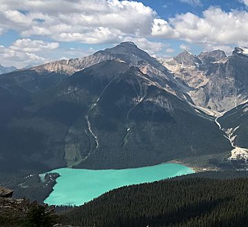
Mount Carnarvon seen with Emerald Lake from Mount Burgess
|
|
| Highest point | |
| Elevation | 3,046 m (9,993 ft) |
| Prominence | 406 m (1,332 ft) |
| Parent peak | The President (3123 m) |
| Listing | Mountains of British Columbia |
| Geography | |
| Location | Yoho National Park British Columbia, Canada |
| Parent range | President Range Canadian Rockies |
| Topo map | NTS 82N/07 |
| Geology | |
| Age of rock | Cambrian |
| Type of rock | sedimentary rock |
| Climbing | |
| First ascent | 1904 by Dominion Topographic Survey |
| Easiest route | Scrambling |
Mount Carnarvon is a tall mountain, about 3,046 meters (10,000 feet) high. It's located in the Kiwetinok River Valley within Yoho National Park in the Canadian Rockies. This park is in British Columbia, Canada.
Its closest taller neighbor is a mountain called The President, which is about 3.9 kilometers (2.4 miles) away. Both are part of the President Range, which is a smaller group within the larger Waputik Mountains. Mount Carnarvon is about five kilometers northwest of Emerald Lake. You can't see it from the lake because Emerald Peak blocks the view. But you can see Mount Carnarvon from Highway 1, also known as the Trans-Canada Highway. The best time to visit or climb Mount Carnarvon is from July to September. The weather is usually good then.
Mountain's Name: A Look Back
Originally called Emerald Mountain, the mountain got its current name in 1900. Alexander MacKinnon Burgess, who worked for the government, named it after Henry Herbert, 4th Earl of Carnarvon. He was an important person in British politics. In 1867, he helped create the British North America Act. This act gave Canada the power to govern itself. Later, in 1874, he helped solve problems between Canada and British Columbia. This agreement was known as the "Carnarvon Terms".
The first time people successfully climbed Mount Carnarvon was in 1904. This climb was done by members of the Dominion Land Survey, a group that mapped out land. The mountain's name was officially approved in 1924 by the Geographical Names Board of Canada.
How Mount Carnarvon Was Formed
Mount Carnarvon is made of sedimentary rock. This type of rock forms from layers of sand, mud, and other materials that settle over time. These rocks were laid down during the Cambrian period, which was a very long time ago.
These rocks formed in shallow seas. Over millions of years, during a process called the Laramide orogeny, these layers of rock were pushed up. They moved east and even slid over younger rock layers, creating the mountains we see today.
Weather and Climate
Mount Carnarvon is in a subarctic climate zone. This means it has very cold, snowy winters. The summers are usually mild. Temperatures can drop below −20 °C (minus 4 °F). With the wind chill, it can feel even colder, sometimes below −30 °C (minus 22 °F). The snow and rain that fall on Mount Carnarvon eventually flow into the Kicking Horse River through smaller streams.
 | Laphonza Butler |
 | Daisy Bates |
 | Elizabeth Piper Ensley |


