Emerald Peak (Yoho) facts for kids
Quick facts for kids Emerald Peak |
|
|---|---|

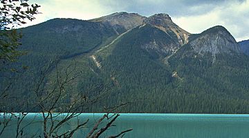
Emerald Peak seen from Emerald Lake
|
|
| Highest point | |
| Elevation | 2,566 m (8,419 ft) |
| Prominence | 166 m (545 ft) |
| Parent peak | Mount Carnarvon (3046 m) |
| Listing | Mountains of British Columbia |
| Geography | |
| Location | Yoho National Park British Columbia, Canada |
| Parent range | President Range Canadian Rockies |
| Topo map | NTS 82N/07 |
| Climbing | |
| Easiest route | Scramble |
Emerald Peak is a tall mountain summit in Yoho National Park, British Columbia, Canada. It stands about 2,701-metre (8,862-foot) high. This impressive peak is part of the President Range, which is a group of mountains within the larger Canadian Rockies.
Emerald Peak's closest higher neighbor is Mount Carnarvon, located about 1.7 km (1.1 mi) to the northwest. Both mountains are part of the President Range, which itself is a smaller part of the Waputik Mountains. You can see Emerald Peak clearly from the beautiful Emerald Lake. It rises about 1,256-metre (4,121-foot) above the lake's northwest shore.
The mountain got its name officially in 1924. It was named after Emerald Lake, which got its name in 1900 because of its amazing green color.
Mountain Facts
Emerald Peak is a popular spot for scrambling, which is a mix of hiking and easy climbing. It's a great way to explore the mountain for those with some experience.
Weather and Climate
Emerald Peak is located in a subarctic climate zone. This means it has very cold, snowy winters and mild summers. Temperatures can drop below −20 °C (or −4 °F). With the wind chill, it can feel even colder, sometimes below −30 °C (−22 °F).
Water from melting snow and rain on Emerald Peak flows into the Emerald River. This river then joins the Kicking Horse River. The best time to visit or climb Emerald Peak is usually from July through September. The weather during these months is generally the most pleasant.
 | Jessica Watkins |
 | Robert Henry Lawrence Jr. |
 | Mae Jemison |
 | Sian Proctor |
 | Guion Bluford |


