Mount Field (British Columbia) facts for kids
Quick facts for kids Mount Field |
|
|---|---|

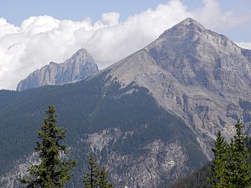
Mount Field with Mount Wapta in the background; near Field, British Columbia, Canada.
|
|
| Highest point | |
| Elevation | 2,643 m (8,671 ft) |
| Prominence | 182 m (597 ft) |
| Listing | Mountains of British Columbia |
| Geography | |
| Parent range | President Range |
| Topo map | NTS 82N/08 |
| Climbing | |
| Easiest route | Scramble |
Mount Field is a tall mountain located in Yoho National Park, Canada. It stands about 10 kilometers (6 miles) east of the small town of Field. This mountain is part of the amazing Canadian Rockies and offers stunning views of the surrounding area.
Contents
Exploring Mount Field
Mount Field is a notable peak in the President Range, which is a smaller part of the larger Canadian Rockies. The mountain reaches an elevation of 2,643 meters (8,671 feet) above sea level. It's a popular spot for scrambling, which is a mix of hiking and easy rock climbing.
Where is Mount Field Located?
This impressive mountain is found in the province of British Columbia, Canada. It's inside Yoho National Park, a beautiful area known for its waterfalls, lakes, and towering peaks. The park is a great place to explore nature and see wildlife.
How Mount Field Got Its Name
Mount Field was named in 1884. It received its name from Cyrus West Field, an American businessman. Mr. Field was famous for helping to lay the first telegraph cables across the Atlantic Ocean. These cables allowed messages to be sent quickly between North America and Europe.
In 1884, Cyrus Field was visiting the Canadian Rockies. He was a guest of the Canadian Pacific Railway (CPR). The CPR was a big company building Canada's first national railway at the time. As a way to honor him, they named both a railway station and this mountain after him.
Fossils Near Mount Field
Below the ridge that connects Mount Field to a nearby peak called Wapta Mountain, you can find a very special place. This area is home to the Burgess Shale. The Burgess Shale is one of the most important fossil sites in the world.
What is the Burgess Shale?
The Burgess Shale contains fossils of ancient sea creatures. These creatures lived over 500 million years ago, during a time called the Cambrian Period. The fossils are incredibly well-preserved, showing soft body parts that usually don't turn into fossils. Scientists learn a lot about early life on Earth from these amazing discoveries.
 | Janet Taylor Pickett |
 | Synthia Saint James |
 | Howardena Pindell |
 | Faith Ringgold |


