
Moraine Lake facts for kids
Quick facts for kids Moraine Lake |
|
|---|---|

Sunrise by Moraine Lake in mid-summer
|
|

Moraine Lake
Location in Alberta
|
|
| Location | Banff National Park, Alberta |
| Coordinates | 51°19′21″N 116°11′08″W / 51.32250°N 116.18556°W |
| Primary inflows | Fay Glacier Larch Creek |
| Primary outflows | Moraine Creek |
| Basin countries | Canada |
| Surface area | 50 ha (0.19 sq mi) |
| Max. depth | 14 metres (46 ft) |
| Surface elevation | 1,884 m (6,181 ft) |
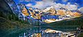
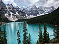
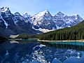
Moraine Lake is a beautiful lake in Banff National Park, Alberta, Canada. It gets its water from glaciers, which are like huge, slow-moving rivers of ice. The lake is about 14 kilometres (8.7 mi) away from the village of Lake Louise.
Moraine Lake sits in a special place called the Valley of the Ten Peaks. It is very high up, at about 1,884 metres (6,181 ft) above sea level. The lake covers an area of about 50 hectares (120 acres).
Because the lake is fed by glaciers, it doesn't get completely full until late June. When it is full, the water turns a stunning bright blue color. This amazing color comes from tiny bits of rock, called rock flour, that the glaciers grind up and carry into the lake. When sunlight hits these tiny rock particles, it bends and scatters the light, making the lake look incredibly blue.
Contents
Visiting Moraine Lake
Hiking Trails
The area around Moraine Lake has many paths for walking and hiking. Sometimes, these paths might be closed for safety reasons.
One of the most popular trails for visitors is called The Rockpile Trail. This path goes along a natural pile of rocks left behind by a glacier, which is called a moraine.
- The Rockpile Trail is about 300 metres (980 ft) long.
- It goes up about 24 metres (79 ft) in height.
From the top of the rockpile, you get an amazing view of the lake and the mountains in the Valley of the Ten Peaks. This view is so famous that it's sometimes called the "Twenty Dollar View." That's because Moraine Lake was shown on the back of the Canadian twenty-dollar bill in 1969 and 1979!
Another trail that starts nearby is the Consolation Lakes trail.
- This trail is about 3 kilometres (1.9 mi) long.
- It goes up about 90 metres (300 ft) in height.
When you reach Consolation Lakes, you can keep going to an upper lake, but there isn't a clear path, so it can be a bit tricky.

Close to the canoe docks at Moraine Lake Lodge, there's another starting point for trails. From here, you can find five different trails:
- Moraine Lake Lakeshore Trail
- Eiffel Lake Trail
- Wenkchemna Pass Trail
- Larch Valley Trail
- Sentinel Pass
Fun on the Lake
You can also enjoy canoeing on Moraine Lake. Imagine paddling across that bright blue water with the stunning mountains all around you!
Moraine Lake in Pop Culture
The beautiful image of Moraine Lake is known all over the world. You might have seen it in many places, such as:
- On the back of the Canadian twenty-dollar bill in 1969 and 1979.
- As a background picture for Google's Android operating system.
- In advertisements for Bernard Callebaut chocolates.
- As a background on old phones like the Blackberry Pearl and Palm Pre.
- In some wallpapers for Windows Vista Starter and Windows 7 (in the "Canada" series).
- As the homepage picture for the Bing search engine on several dates.
- As the National Geographic Travel Photo of the Day on October 8, 2013.
- In the video game The Last of Us, it appears as a photo in Joel's Texas home.
- On a postcard in the video game Until Dawn.
- In the login screen of Windows 10.
- On a special silver coin from the Royal Canadian Mint, based on a photo by Peter McKinnon.
Image gallery
-
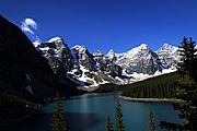
Moraine Lake from the Rockpile
-
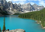
The blue-green colour of the lake is due to glacial rock flour.
-
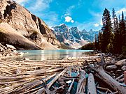
Moraine Lake in Banff National Park with floating timber
-
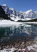
Moraine Lake is still mostly frozen in May and a considerable amount of snow is still in the area and the surrounding mountains.


Images for kids
-
Moraine Lake at Sunset
-
Moraine Lake in June 2018
-
Reflection of surrounding peaks


See also
 In Spanish: Lago Moraine para niños
