Mount Assiniboine facts for kids
Quick facts for kids Mount Assiniboine |
|
|---|---|

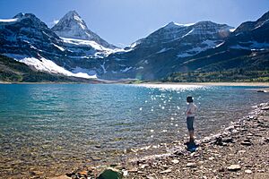
Mount Assiniboine seen from above Lake Magog
|
|
| Highest point | |
| Elevation | 3,618 m (11,870 ft) |
| Prominence | 2,086 m (6,844 ft) |
| Listing |
|
| Geography | |
| Location | Alberta–British Columbia border, Canada |
| Parent range | Canadian Rockies (Assiniboine Area) |
| Topo map | NTS 82J/13 Mount Assiniboine |
| Climbing | |
| First ascent | 1901 by James Outram, Christian Bohren and Christian Hasler |
| Easiest route | rock/snow climb (II/5.5) |
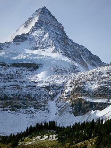
Mount Assiniboine, also known as Assiniboine Mountain, is a famous mountain in Canada. It has a unique pyramidal peak shape. This mountain sits right on the Great Divide. This means it is on the border between British Columbia and Alberta.
Mount Assiniboine is about 3,618 meters (11,870 feet) tall. It is the highest peak in the southern part of the Canadian Rockies. The mountain rises almost 1,525 meters (5,000 feet) above Lake Magog. Many people call it the "Matterhorn of the Rockies". This is because it looks a lot like the famous Matterhorn mountain in the Alps.
Naming the Mountain
The name Mount Assiniboine was given by George Mercer Dawson in 1885. He was exploring the area at the time. When Dawson saw the mountain from Copper Mountain, he noticed something special. A cloud plume was trailing away from the very top of the peak.
This cloud reminded him of smoke plumes. These plumes often came from the teepees of the Assiniboine people. The Assiniboine are a First Nations group. That's how the mountain got its unique name.
Where is Mount Assiniboine?
Mount Assiniboine is located on the edge of two important parks. It is partly in Mount Assiniboine Provincial Park in British Columbia. The other part is in Banff National Park in Alberta.
There are no roads that go directly to the mountain. This means you cannot drive right up to it. To reach Mount Assiniboine, you need to travel by foot or helicopter. A hike or horse-pack trip can take about six hours. This journey covers about 27 kilometers (17 miles).
In the past, people could also bike part of the way. However, this is now not allowed. This rule helps to keep both people and grizzly bears safe. The most common way to get there is through Bryant Creek. You can start from the Mount Shark parking lot near Canmore. The trail is clearly marked. There is also a place for helicopters to land there.
Climbing Mount Assiniboine
Mount Assiniboine is a challenging mountain to climb. The first time anyone successfully climbed it was in the summer of 1901. This historic climb was made by James Outram, Christian Bohren, and Christian Hasler.
Years later, in 1925, Lawrence Grassi achieved another amazing feat. He became the first person to climb Mount Assiniboine all by himself. On August 27, 2001, a special climb took place. Christian Bohren's granddaughter, Lonnie, joined three others. They successfully reached the summit. This climb celebrated 100 years since the very first ascent.
There are no easy "scrambling" routes up Mount Assiniboine. Scrambling is a mix of hiking and easy climbing. The easiest ways to climb this mountain are called the North Ridge and North Face routes. These routes are rated at YDS 5.5. Climbers usually start these routes from a place called the Hind Hut.
See also
 In Spanish: Monte Assiniboine para niños
 | Jackie Robinson |
 | Jack Johnson |
 | Althea Gibson |
 | Arthur Ashe |
 | Muhammad Ali |


