
Mount Rundle facts for kids
Quick facts for kids Mount Rundle |
|
|---|---|

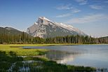
Mount Rundle as seen from Vermilion Lakes
|
|
| Highest point | |
| Elevation | 2,948 m (9,672 ft) |
| Prominence | 1,304 m (4,278 ft) |
| Geography | |

Mount Rundle
Location in Alberta
|
|
| Parent range | Canadian Rockies (South Banff Ranges/Rundle Peaks) |
| Topo map | NTS 82O/03 |
| Climbing | |
| First ascent | 1888 by J.J. McArthur |
| Easiest route | Scramble |
Mount Rundle is a famous mountain in Canada. It is located in Banff National Park in Alberta. This mountain looks over the towns of Banff and Canmore, Alberta.
The Cree people originally called it Waskahigan Watchi. This name means "house mountain." In 1858, John Palliser renamed the mountain. He named it after Reverend Robert Rundle. Reverend Rundle was a Methodist missionary. He worked in western Canada in the 1840s. He helped create a written language for the Cree people. He visited the Stoney-Nakoda people near Mount Rundle in 1844 and 1847.
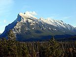
Mount Rundle is actually a small mountain range. It stretches for over 12 kilometers (about 7.5 miles). It goes from Banff to Canmore. Along this stretch, it has seven different peaks. The third peak from Banff is the tallest. It stands at about 2,948 meters (9,675 feet) high. A part of the mountain near Canmore is called the East End of Rundle. People often call it EEOR. Mount Rundle is part of the South Banff Ranges. Other mountains in this group include the Sundance Range and Sulphur Mountain.
Contents
How Mount Rundle Was Formed
Mount Rundle is made of different types of rock. These include limestone, dolomite, and shale. These rocks formed a very long time ago. Geologists (scientists who study rocks) often describe Mount Rundle as a "sandwich."
The Rock Sandwich
Imagine a sandwich with three main layers. The bottom layer is made of strong, grey limestone and dolomite. This is like the bottom slice of bread. Above this is a softer layer of dark shale. This is like the sandwich filling. On top is another layer of grey limestone and dolomite. This forms the massive upper cliffs of the mountain. This top layer is like the top slice of bread. There's also a thin layer of shale between the bottom "bread" and the "filling." This is like a lettuce leaf in the sandwich.
How the Mountain Got Its Shape
Mount Rundle's shape comes from how these rock layers were pushed and tilted. Long ago, huge sheets of rock slid over each other. This happened when tectonic plates collided. This event created the southern Canadian Rockies. The rocks on Mount Rundle were tilted steeply. This tilting gives the mountain its unique shape.
Later, about 2 million years ago, glaciers carved the mountains. They shaped the valleys and peaks. After the glaciers melted, streams and rivers continued to change the landscape. This is how Mount Rundle got its final look.
.JPG)
Rundle Stone
Rundle rock or Rundle stone is a special natural stone. It was first taken from Mount Rundle. This stone is often used in southern Alberta. People use it for landscaping and building. For example, it was used to build the famous Banff Springs Hotel. It is also found in many Parks Canada buildings. This stone is a type of sandstone. It formed during the Triassic Period.
Hiking and Scrambling Mount Rundle
Mount Rundle is a popular place for scrambling. Scrambling is a type of hiking that involves using your hands for balance. It's more challenging than a regular hike.
Routes Near Canmore
Near Canmore, there is a well-known scramble called the Goat Creek hiking trail. This trail starts near the Canmore Reservoir. This is also the beginning of the Mount Rundle Traverse. This is a very challenging trek. It involves climbing all of Rundle's peaks from Goat Creek to the Banff Springs Hotel.
Routes Near Banff
In Banff, the Mount Rundle Trail starts near the Spray River bridge. This trail leads to the first peak. The hike usually takes 8 to 10 hours. It is about 5 kilometers (3 miles) one-way. Hikers gain about 993 meters (3,258 feet) in elevation to the first cliff. To reach the summit, the gain is about 1,579 meters (5,180 feet).
Even though it's called "non-technical," it can be very tiring. Partway up, there's a large watercourse called the Central Gully. It looks like a path but it's a dead end. The correct route crosses this watercourse and then turns left. As you get above the treeline, you reach a part called the "Dragon's Back." Here, the path gets narrow between two steep gullies. The biggest challenge here is walking on loose rocks, called scree. It can feel like taking two steps forward and one step back.
Amazing Views of Mount Rundle
Mount Rundle is one of Canada's most recognized mountains. Many artists have been inspired by it. Walter Joseph Phillips, a famous painter, loved painting Mount Rundle. He said it was his "bread and butter mountain" because it was never the same. Its colors change from orange to blue-grey, with hints of violet and green.
From Vermilion Lakes
One of the most famous places to take pictures of Mount Rundle is from Vermilion Lakes. This spot is about 5 kilometers (3 miles) from the mountain. You can see Mount Rundle reflected in the lakes, which makes for beautiful photos.
- Scenic viewpoints
-
Mount Rundle seen from Vermilion Lakes
-
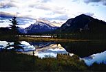
Mount Rundle reflected in the Vermilion Lakes
-
Mount Rundle seen from the Bow Valley
-
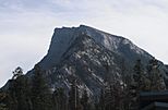
Mount Rundle, south face


You can also see Mount Rundle from Mount Norquay. The Banff Fairmont hotel also has great views of Mount Rundle and Tunnel Mountain.
Images for kids
-
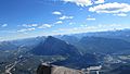
Mount Rundle, Banff, Alberta seen from Cascade Mountain Summit

See also
 In Spanish: Monte Rundle para niños
