
East End of Rundle facts for kids
Quick facts for kids East End of Rundle (EEOR) |
|
|---|---|

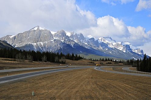
East End of Rundle seen from westbound Highway 1
|
|
| Highest point | |
| Elevation | 2,590 m (8,500 ft) |
| Geography | |

East End of Rundle (EEOR)
Location in Alberta

East End of Rundle (EEOR)
Location in Canada
|
|
| Location | Alberta, Canada |
| Parent range | South Banff Ranges, Canadian Rockies |
| Topo map | NTS 82O/3 Canmore |
| Climbing | |
| Easiest route | easy/moderate scramble |
The East End of Rundle (EEOR) is a mountain located right next to the town of Canmore in Alberta, Canada. It's a part of the incredible Canadian Rockies mountain range. EEOR is found just west of the Spray Lakes road. It's a popular spot for outdoor activities.
Mount Rundle is a larger mountain that sits between Canmore and Banff. EEOR is actually the easternmost part of this big Mount Rundle formation.
Contents
Exploring East End of Rundle
There is a special way to climb up EEOR called a "scrambling route." Scrambling is like a mix between hiking and rock climbing. It means you use both your hands and feet to get up steep, rocky parts of the mountain. It's a fun challenge for people who enjoy outdoor adventures! This route starts from the Spray Lakes road.
How Mountains Formed
Rocks of EEOR
The rocks that make up EEOR are called sedimentary rocks. These rocks were formed a very, very long time ago. Imagine tiny bits of sand, mud, and shells settling at the bottom of ancient shallow seas. Over millions of years, these layers got squished and hardened into rock.
Mountain Building
Later, huge forces deep inside the Earth pushed these rock layers. This happened during an event called the Laramide orogeny. It was like a giant slow-motion collision that folded and lifted the land. This process created the big mountains we see today, including EEOR.
Weather in the Rockies
Climate Type
The East End of Rundle is in a subarctic climate zone. This means it has very cold, snowy winters. Summers are usually mild, not too hot.
Temperatures and Snow
In winter, temperatures can drop really low, sometimes even below -20 °C. With the wind, it can feel even colder, below -30 °C! Lots of snow falls on the mountain during the colder months.
Water Flow
When snow melts or rain falls on Rundle, the water flows down the mountain. This water eventually drains into the Bow River. The Bow River is a big river that flows into the Saskatchewan River.
Gallery
-
Mount Rundle with the East End to left
-
EEOR (left) and Ha-Ling (right) viewed from the South with Canmore in the background (Sept. 2006)


