Finlay River facts for kids
Quick facts for kids Finlay River |
|
|---|---|

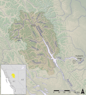
Map of the Finlay River
|
|
| Country | Canada |
| Province | British Columbia |
| Physical characteristics | |
| Main source | Thutade Lake 1,200 metres (3,900 ft) 57°04′30″N 126°53′26″W / 57.07513°N 126.89063°W |
| River mouth | Williston Lake 700 metres (2,300 ft) 56°53′38″N 124°57′02″W / 56.89397°N 124.95057°W |
| Length | 420 kilometres (260 mi) |
| Basin features | |
| Basin size | 43,000 square kilometres (17,000 sq mi) |
The Finlay River is a long river in northern British Columbia, Canada. It flows for about 402 kilometers (250 miles). The river starts in Thutade Lake in the Omineca Mountains. It then flows north and finally south into Williston Lake. Williston Lake was formed when the W. A. C. Bennett Dam was built in 1968.
Before the dam, the Finlay River joined with the Parsnip River to form the Peace River. The Finlay River's source at Thutade Lake is considered the very beginning of the huge Mackenzie River system. A place called Deserters Canyon is located just north of Williston Lake.
About the Finlay River
The Finlay River drains a large area of land, about 43,000 square kilometers (16,600 square miles). This means it collects water from a very big region. On average, it sends about 600 cubic meters (21,000 cubic feet) of water downstream every second.
Many smaller rivers flow into the Finlay River. These are called tributaries. Some of the main ones include the Ingenika, Warneford, Fox, Toodoggone, and Firesteel Rivers. The Ospika River used to join the Finlay, but now it flows directly into Williston Lake.
The Finlay River flows through a very remote part of British Columbia. There are no large towns or cities along the river. However, there is a small First Nations community called Fort Ware. It is located where the Finlay and Warneford rivers meet. Tatlatui Provincial Park helps protect the area around the Tatlatui Range, which is where Thutade Lake is found.
History of the Finlay River
The Finlay River is named after John Finlay, an explorer who traveled a short distance up the river in 1797. The first European to journey the entire length of the river, all the way to its source, was a fur trader and explorer named Samuel Black. He made this journey in 1824.
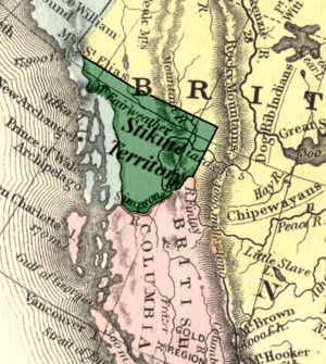
The river played a role in defining the borders of early British Columbia. When the Colony of British Columbia was created in 1858, the Finlay River formed the eastern half of its northern boundary. North of this boundary was the North-Western Territory.
For a short time, from 1862 to 1863, the Finlay River was also the southern border of the Stikine Territory. This territory was formed from the North-Western Territory because of gold rushes in the Peace and Stikine areas. The Stikine Territory later became part of the Colony of British Columbia.
Tributaries
- Firesteel River
- Toodoggone River
- Fox River
- Kwadacha River
- Paul River
- Akie River
- Ingenika River
- Davis River
- Mesilinka River
- Osilinka River
See also
 In Spanish: Río Finlay para niños
 | Mary Eliza Mahoney |
 | Susie King Taylor |
 | Ida Gray |
 | Eliza Ann Grier |


