
Dettah facts for kids
Quick facts for kids
Dettah
Tʼèɂehdaà
|
|
|---|---|
|
Yellowknives Dene First Nation (Dettah)
|
|
 |
|

Dettah
Location in Northwest Territories

Dettah
Location in Canada
|
|
| Country | Canada |
| Territory | Northwest Territories |
| Region | North Slave Region |
| Territorial electoral district | Tu Nedhé-Wiilideh |
| Census division | Region 6 |
| Area | |
| • Land | 1.12 km2 (0.43 sq mi) |
| Elevation | 179 m (587 ft) |
| Population
(2021)
|
|
| • Total | 192 |
| • Density | 171.9/km2 (445/sq mi) |
| Time zone | UTC−07:00 (MST) |
| • Summer (DST) | UTC−06:00 (MDT) |
| Canadian Postal code |
X1A
|
| Area code(s) | 867 |
| Telephone exchanges | 444 445 446 669 765 766 873 920 |
| Sources: Department of Municipal and Community Affairs, Prince of Wales Northern Heritage Centre, Canada Flight Supplement |
|
Dettah is a special community in the Northwest Territories, Canada. It is a First Nations community, meaning it is home to one of Canada's original peoples. You can find Dettah in the North Slave Region, just southeast of Yellowknife, the capital city.
The name T'é?ehdaá means 'Burnt Point' in the Wíílíídeh language. This was the original name used by the local people. Later, it was simplified to Dettah because it was easier for non-Indigenous people to say. For a long time, this spot was a popular place for the Tetsǫ́tʼine (Yellowknives) people to fish. Today, about 200 Indigenous people live here.
You can get to Dettah from Yellowknife in two ways. In winter, when the Great Slave Lake freezes, you can drive across the ice road. This short drive is about 6.5 kilometers (4 miles). The rest of the year, you take a longer drive of about 27 kilometers (17 miles) on the Ingraham Trail.
Contents
Who Lives in Dettah?
Dettah is home to the Yellowknives people. They are part of the Yellowknives Dene First Nation (Dettah). This community, along with Ndilǫ, represents the Yellowknives people. They are also part of the Akaitcho Territory Government.
How Many People Live Here?
In 2021, a count of people called the 2021 Canadian census showed that 192 people lived in Dettah. They lived in 79 homes. This was a small change from 2016, when 219 people lived there. Dettah is a small area, only about 1.12 square kilometers (0.43 square miles).
What is the Weather Like in Dettah?
Dettah has a subarctic climate. This means it has very long and cold winters. The summers are short but can be mild or even warm. Dettah and nearby Yellowknife are known for having very sunny springs and summers compared to other Canadian cities.
The weather information for Dettah comes from the Yellowknife Airport. This airport is about 9 kilometers (5.6 miles) northwest of Dettah.
| Climate data for Yellowknife (Yellowknife Airport) WMO ID: 71936; coordinates 62°27′46″N 114°26′25″W / 62.46278°N 114.44028°W; elevation: 205.7 m (675 ft); 1981–2010 normals, extremes 1942–present |
|||||||||||||
|---|---|---|---|---|---|---|---|---|---|---|---|---|---|
| Month | Jan | Feb | Mar | Apr | May | Jun | Jul | Aug | Sep | Oct | Nov | Dec | Year |
| Record high humidex | 2.9 | 6.1 | 8.9 | 20.2 | 25.6 | 34.0 | 35.4 | 34.3 | 27.2 | 18.1 | 6.3 | 1.6 | 35.4 |
| Record high °C (°F) | 3.4 (38.1) |
6.2 (43.2) |
9.3 (48.7) |
20.4 (68.7) |
26.3 (79.3) |
31.1 (88.0) |
32.5 (90.5) |
32.6 (90.7) |
26.1 (79.0) |
19.0 (66.2) |
7.8 (46.0) |
2.8 (37.0) |
32.6 (90.7) |
| Mean maximum °C (°F) | −7.3 (18.9) |
−4.9 (23.2) |
1.6 (34.9) |
11.4 (52.5) |
20.6 (69.1) |
26.3 (79.3) |
28.4 (83.1) |
26.5 (79.7) |
19.3 (66.7) |
10.2 (50.4) |
1.1 (34.0) |
−5.0 (23.0) |
28.8 (83.8) |
| Mean daily maximum °C (°F) | −21.6 (−6.9) |
−18.1 (−0.6) |
−10.8 (12.6) |
0.4 (32.7) |
9.7 (49.5) |
18.1 (64.6) |
21.3 (70.3) |
18.1 (64.6) |
10.4 (50.7) |
0.9 (33.6) |
−10.0 (14.0) |
−17.8 (0.0) |
0.0 (32.0) |
| Daily mean °C (°F) | −25.6 (−14.1) |
−22.9 (−9.2) |
−16.8 (1.8) |
−5.3 (22.5) |
4.6 (40.3) |
13.3 (55.9) |
17.0 (62.6) |
14.2 (57.6) |
7.2 (45.0) |
−1.7 (28.9) |
−13.7 (7.3) |
−21.8 (−7.2) |
−4.3 (24.3) |
| Mean daily minimum °C (°F) | −29.5 (−21.1) |
−27.5 (−17.5) |
−22.7 (−8.9) |
−11.0 (12.2) |
−0.5 (31.1) |
8.5 (47.3) |
12.6 (54.7) |
10.2 (50.4) |
4.0 (39.2) |
−4.2 (24.4) |
−17.5 (0.5) |
−25.7 (−14.3) |
−8.6 (16.5) |
| Mean minimum °C (°F) | −42.1 (−43.8) |
−39.8 (−39.6) |
−36.3 (−33.3) |
−25.7 (−14.3) |
−9.3 (15.3) |
1.9 (35.4) |
7.7 (45.9) |
3.6 (38.5) |
−2.6 (27.3) |
−15.8 (3.6) |
−31.1 (−24.0) |
−38.5 (−37.3) |
−43.1 (−45.6) |
| Record low °C (°F) | −51.2 (−60.2) |
−51.2 (−60.2) |
−43.3 (−45.9) |
−40.6 (−41.1) |
−22.8 (−9.0) |
−4.4 (24.1) |
0.6 (33.1) |
−0.6 (30.9) |
−9.7 (14.5) |
−28.9 (−20.0) |
−44.4 (−47.9) |
−48.3 (−54.9) |
−51.2 (−60.2) |
| Record low wind chill | −64.0 | −61.0 | −56.8 | −53.2 | −31.8 | −11.2 | 0.0 | −4.8 | −16.4 | −36.3 | −54.7 | −58.9 | −64.0 |
| Average precipitation mm (inches) | 14.3 (0.56) |
14.1 (0.56) |
13.9 (0.55) |
11.3 (0.44) |
18.4 (0.72) |
28.9 (1.14) |
40.8 (1.61) |
39.3 (1.55) |
36.3 (1.43) |
30.3 (1.19) |
24.8 (0.98) |
16.2 (0.64) |
288.6 (11.36) |
| Average rainfall mm (inches) | 0.1 (0.00) |
0.0 (0.0) |
0.2 (0.01) |
2.5 (0.10) |
13.8 (0.54) |
28.9 (1.14) |
40.8 (1.61) |
39.2 (1.54) |
32.7 (1.29) |
12.1 (0.48) |
0.3 (0.01) |
0.2 (0.01) |
170.7 (6.72) |
| Average snowfall cm (inches) | 19.7 (7.8) |
20.0 (7.9) |
18.5 (7.3) |
10.3 (4.1) |
4.7 (1.9) |
0.0 (0.0) |
0.0 (0.0) |
0.1 (0.0) |
3.5 (1.4) |
20.9 (8.2) |
36.5 (14.4) |
23.5 (9.3) |
157.6 (62.0) |
| Average precipitation days (≥ 0.2 mm) | 10.7 | 10.0 | 8.4 | 5.0 | 6.6 | 7.6 | 9.6 | 10.5 | 11.2 | 13.4 | 14.4 | 11.2 | 118.5 |
| Average rainy days (≥ 0.2 mm) | 0.2 | 0.1 | 0.3 | 1.2 | 5.3 | 7.5 | 9.6 | 10.4 | 10.6 | 5.5 | 0.6 | 0.2 | 51.3 |
| Average snowy days (≥ 0.2 cm) | 11.9 | 11.0 | 9.2 | 4.4 | 2.1 | 0.1 | 0.0 | 0.1 | 1.2 | 10.0 | 16.0 | 12.8 | 78.6 |
| Average relative humidity (%) | 64.6 | 61.6 | 54.7 | 52.5 | 45.9 | 45.2 | 47.9 | 55.7 | 64.7 | 75.2 | 77.8 | 69.2 | 59.6 |
| Mean monthly sunshine hours | 50.6 | 107.3 | 188.4 | 276.4 | 335.7 | 373.8 | 358.0 | 276.2 | 157.7 | 65.0 | 42.7 | 24.6 | 2,256.5 |
| Percent possible sunshine | 26.8 | 43.5 | 51.8 | 62.2 | 60.8 | 63.0 | 61.2 | 55.5 | 40.3 | 21.0 | 20.2 | 15.4 | 43.5 |
| Average ultraviolet index | 0 | 0 | 1 | 2 | 4 | 5 | 5 | 4 | 2 | 1 | 0 | 0 | 2 |
| Source 1: Environment and Climate Change Canada and Weather Atlas wind chill | |||||||||||||
| Source 2: Météo Climat (mean maximum) (mean minimum) | |||||||||||||
Images for kids
-
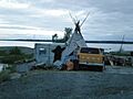
Bear skin drying
-
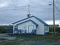
Kateri Tekakwitha church
-
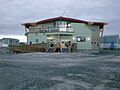
First Nation Band Office
-
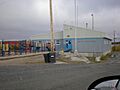
Kaw Tay Whee School
-
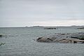
The Great Slave Lake at Dettah


