
Hay River Reserve facts for kids
Quick facts for kids
Hay River Reserve
Kʼatlodeeche/Katlʼodeeche First Nation
Hay River Dene 1
|
|
|---|---|
|
Kʼatlodeeche First Nation
|
|

Hay River Reserve
Location in Northwest Territories

Hay River Reserve
Location in Canada
|
|
| Country | Canada |
| Territory | Northwest Territories |
| Region | South Slave Region |
| Constituency | Deh Cho |
| Census division | Region 4 |
| Area | |
| • Land | 134.00 km2 (51.74 sq mi) |
| Elevation | 165 m (541 ft) |
| Population
(2021)
|
|
| • Total | 259 |
| • Density | 1.9/km2 (5/sq mi) |
| Time zone | UTC−07:00 (MST) |
| • Summer (DST) | UTC−06:00 (MDT) |
| Canadian Postal code |
X0E 1G4
|
| Area code(s) | 867 |
| Telephone exchange | 874 |
| - Food price index | 116.2 |
| Sources: Department of Municipal and Community Affairs, Prince of Wales Northern Heritage Centre, Canada Flight Supplement 2015 figure based on Yellowknife = 100 |
|
The Hay River Reserve is a special area of land in Canada's Northwest Territories. It is also known as the Kʼatlodeeche/Katlʼodeeche First Nation or Hay River Dene 1. This reserve is one of only three such areas in the Northwest Territories.
It is located in the South Slave Region. The community is home to people from the Slavey group. Most of the 259 people living here are First Nations people. Some are also Métis. The main languages spoken are South Slavey and English.
The reserve covers a large area of land, about 13,517 hectares. A group called the Band Council governs the reserve. This council includes a Chief and four Counsellors. They are chosen every two years on "Treaty Day." The reserve also runs businesses like the Ehdah Cho Store and the Nats’jee Keh Treatment Centre.
Children in the community go to school at the Chief Sunrise Education Centre. This school provides both primary and secondary education.
History of Hay River Reserve

For many years, the Dene people used the area around the Hay River for fishing. But it wasn't until the 1890s that people started to settle there. Chief Chiatlo led a group to this spot. Later, both the Anglican and Roman Catholic Church set up missions and schools. Trading posts and the Royal Canadian Mounted Police also arrived. The NWT Government says the first building was from the Hudson's Bay Company.
The first settlement was right at the mouth of the river, east of Vale Island. But this area often flooded. So, everyone decided to move to a new spot. The current reserve is on the south side of the Hay River. It is close to where the river meets Great Slave Lake.
In 1974, the chief at that time, Daniel Sonfrere, worked out an agreement with the Government of Canada. This led to the creation of the first reserve in the Northwest Territories.
The original mission buildings are now a very important historical site. This includes St. Peter's Anglican Church and Ste. Anne's Roman Catholic Church. There are also old rectory remains and cemeteries. In 1992, this site became a National Historic Site of Canada. It is important because it shows where Dene and European cultures met.
Climate and Weather
Hay River has a subarctic climate. This means it has mild to warm summers. But the winters are very long and cold.
| Climate data for Hay River (Hay River/Merlyn Carter Airport) WMO ID: 71935; coordinates 60°50′23″N 115°46′58″W / 60.83972°N 115.78278°W; elevation: 164.9 m (541 ft); 1981–2010 normals, extremes 1893–present |
|||||||||||||
|---|---|---|---|---|---|---|---|---|---|---|---|---|---|
| Month | Jan | Feb | Mar | Apr | May | Jun | Jul | Aug | Sep | Oct | Nov | Dec | Year |
| Record high humidex | 10.6 | 12.9 | 14.6 | 25.8 | 31.1 | 35.1 | 44.6 | 39.8 | 32.2 | 25.4 | 12.8 | 11.2 | 44.6 |
| Record high °C (°F) | 10.7 (51.3) |
13.9 (57.0) |
15.6 (60.1) |
26.0 (78.8) |
33.3 (91.9) |
34.0 (93.2) |
35.6 (96.1) |
36.7 (98.1) |
31.7 (89.1) |
25.6 (78.1) |
15.0 (59.0) |
14.4 (57.9) |
36.7 (98.1) |
| Mean daily maximum °C (°F) | −17.3 (0.9) |
−14.2 (6.4) |
−7.8 (18.0) |
2.9 (37.2) |
10.7 (51.3) |
18.0 (64.4) |
21.2 (70.2) |
19.6 (67.3) |
13.2 (55.8) |
4.1 (39.4) |
−7.7 (18.1) |
−14.4 (6.1) |
2.4 (36.3) |
| Daily mean °C (°F) | −21.8 (−7.2) |
−19.6 (−3.3) |
−13.8 (7.2) |
−2.7 (27.1) |
5.4 (41.7) |
12.5 (54.5) |
16.1 (61.0) |
14.6 (58.3) |
8.7 (47.7) |
0.5 (32.9) |
−11.6 (11.1) |
−18.8 (−1.8) |
−2.5 (27.5) |
| Mean daily minimum °C (°F) | −26.2 (−15.2) |
−24.9 (−12.8) |
−19.8 (−3.6) |
−8.1 (17.4) |
0.0 (32.0) |
7.0 (44.6) |
10.9 (51.6) |
9.5 (49.1) |
4.1 (39.4) |
−3.2 (26.2) |
−15.4 (4.3) |
−23.1 (−9.6) |
−7.4 (18.7) |
| Record low °C (°F) | −52.2 (−62.0) |
−50.6 (−59.1) |
−47.2 (−53.0) |
−40.0 (−40.0) |
−24.4 (−11.9) |
−6.1 (21.0) |
−1.7 (28.9) |
−6.7 (19.9) |
−15.6 (3.9) |
−26.1 (−15.0) |
−40.8 (−41.4) |
−51.1 (−60.0) |
−52.2 (−62.0) |
| Record low wind chill | −59 | −60 | −55 | −48 | −27 | −7 | 0 | 0 | −17 | −34 | −54 | −56 | −60 |
| Average precipitation mm (inches) | 16.4 (0.65) |
14.3 (0.56) |
14.4 (0.57) |
12.6 (0.50) |
23.3 (0.92) |
31.9 (1.26) |
43.0 (1.69) |
58.7 (2.31) |
44.6 (1.76) |
35.7 (1.41) |
24.8 (0.98) |
16.8 (0.66) |
336.4 (13.24) |
| Average rainfall mm (inches) | 0.1 (0.00) |
0.2 (0.01) |
0.2 (0.01) |
4.3 (0.17) |
18.0 (0.71) |
31.9 (1.26) |
43.0 (1.69) |
58.7 (2.31) |
43.0 (1.69) |
16.8 (0.66) |
0.9 (0.04) |
0.3 (0.01) |
217.4 (8.56) |
| Average snowfall cm (inches) | 19.2 (7.6) |
16.9 (6.7) |
16.4 (6.5) |
8.7 (3.4) |
5.2 (2.0) |
0.1 (0.0) |
0.0 (0.0) |
0.0 (0.0) |
1.5 (0.6) |
19.9 (7.8) |
30.4 (12.0) |
20.7 (8.1) |
138.9 (54.7) |
| Average precipitation days (≥ 0.2 mm) | 11.3 | 9.7 | 8.5 | 5.0 | 8.0 | 8.8 | 9.9 | 11.3 | 12.2 | 12.6 | 14.2 | 11.4 | 122.8 |
| Average rainy days (≥ 0.2 mm) | 0.1 | 0.2 | 0.2 | 2.0 | 6.7 | 8.8 | 9.9 | 11.3 | 11.9 | 6.2 | 1.0 | 0.6 | 58.9 |
| Average snowy days (≥ 0.2 cm) | 12.0 | 10.1 | 8.7 | 3.7 | 1.8 | 0.1 | 0.0 | 0.0 | 0.8 | 8.1 | 14.5 | 12.4 | 72.2 |
| Average relative humidity (%) (at 15:00) | 69.2 | 66.3 | 61.3 | 60.2 | 55.0 | 54.4 | 57.6 | 59.9 | 62.5 | 70.6 | 78.0 | 73.7 | 64.0 |
| Source: Environment and Climate Change Canada | |||||||||||||
Arts and Culture
The Hay River Reserve is the setting for a children's book called Smelly Socks. Robert Munsch wrote the book, and Michael Martchenko drew the pictures. Robert Munsch got the idea for the story from a girl named Tina. He met her when he visited the reserve in 1984. The pictures in the book are based on real photos of Tina and the community. These photos were provided by a local artist named Frederick Lepine.
Images for kids
-
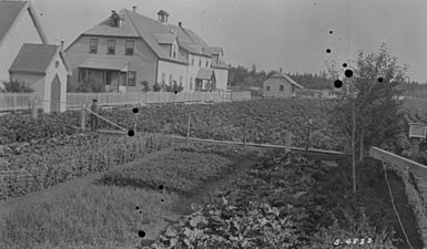
Hay River Mission site
-
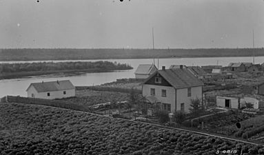
A view of the Hay River settlement from the Mission Boarding School, 1922
-
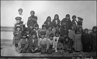
Children on their way to school in Hay River, 1931
-
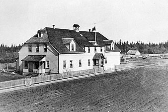
St. Luke's English Church Mission School, Hay River, 1922
-
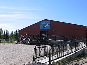
Chief Sunrise Education Centre, 2004

.jpg)
,_1931_(13929401648).jpg)
,_1922_(14112742641).jpg)

