Taltson River facts for kids
Quick facts for kids Taltson River |
|
|---|---|

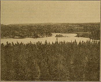
Junction of the Tazin and Taltson Rivers, 1931
|
|
| Country | Canada |
| Territory | Northwest Territories |
| Physical characteristics | |
| River mouth | 61°26′52″N 112°43′40″W / 61.44778°N 112.72778°W |
| Basin features | |
| Basin size | 60,000 km2 (23,000 sq mi) |
| Tributaries |
|
The Taltson River is a long river, about 500 km (310 mi) (310 miles) in length. It flows through the Northwest Territories of Canada. This river eventually empties into the large Great Slave Lake. Along its path, there are three structures that help control the river's flow for hydroelectric power, which means making electricity from water. There is also one power station.
Contents
What's in a Name?
The Taltson River has had a few different names over time. It was once called the Copper Indian River. This name came from the Dene people, an Indigenous group, specifically the Yellowknives or Copper Indians.
The name Taltson comes from the word Tatsan. This word means "scum of water" and refers to copper. In 1918, a government report said the name meant "between high rocks." Other old names for the river include Rocher, Rock, T'altsan, and Yellow Knife.
The Taltson River Basin
The area that the Taltson River and its smaller rivers drain is called its basin. This basin is a cool place with very cold winters. It covers a huge area, about 60,000 km2 (23,000 sq mi) (23,000 square miles). This region is located between Lake Athabasca and Great Slave Lake.
The basin is full of many lakes that are connected to each other. Water from these lakes first flows southwest. Then, it turns north and flows into the lower lands of the Slave River. The Tazin River is a very important river that flows into the Taltson. There are also three structures in the basin that help control water for hydroelectric power. These are found at Nonacho Lake, Tazin Lake, and Twin Gorges.
The River's Journey
The Taltson River starts near lakes like Coventry Lake and Dymond Lake. It flows north to McArthur Lake. Then, it turns west towards Gray Lake, which is part of Nonacho Lake. Nonacho Lake is the biggest lake in the whole river basin.
Water from Nonacho Lake flows into the Taltson River in two ways. It goes directly through the Nonacho Dam. It also flows indirectly through Tronka Chua Gap, Tronka Chua Lake, and Thekulthili Lake. These waters then rejoin the main river at Lady Grey Lake.
From Nonacho Lake to the Twin Gorges Forebay, the river passes through many lakes. It also has sections with gentle slopes, rapids, and waterfalls. Often, there's just a short stretch of rapids between one lake and the next. Some of the bigger lakes in this part are Taltson Lake, King Lake, and Lady Grey Lakes.
After Lady Grey Lake, the river flows for about 110 km (68 mi) (68 miles) to the Twin Gorges Forebay. Here, the Tazin River, its largest branch, joins it.
At the Twin Gorges Forebay, there is a power plant that makes electricity from water. From there, the water flows over Elsie Falls. It then travels for 33 km (21 mi) (21 miles) to Tsu Lake. Along this path, it goes through rapids and a narrow gorge called Nende Chute. The Konth River also flows into Tsu Lake from the northeast.
Downstream from Tsu Lake, the river flows north for 132 km (82 mi) (82 miles) to Great Slave Lake. It passes through Deskenatlata Lake. The Rutledge River and Tethul River also join the Taltson in this area.
A place called Rocher River, on the east side of the lower Taltson River, used to be a trading post. This was a place where people traded goods. It closed in 1963, and residents were encouraged to move to Fort Resolution. Finally, the Taltson River flows into the southern shore of Great Slave Lake.
Making Electricity from Water
The Taltson River is important for making clean energy. A dam on Tazin Lake sends most of its water to another river system, the Charlot River. This water then helps power hydroelectric facilities that provide electricity to Saskatchewan.
The Taltson Dam was built in 1966. Its main purpose was to provide power to a lead-zinc mine at Pine Point. The Taltson Hydro plant is about 64 km (40 mi) (40 miles) north of Fort Smith. It is located on the Taltson River at Twin Gorges Forebay.
This plant has a powerful unit that can generate 18 megawatts of electricity. It sends power through 200 km (120 mi) (124 miles) of power lines. This electricity goes to towns like Fort Smith, Hay River, Fort Resolution, and Enterprise.
Some people have said that the power plant causes flooding downstream. However, the Northwest Territories Power Corporation (NTPC) says that the plant works in a way that has very little effect on the river's natural flow. They explain that if there's a lot of water flowing upstream, there will naturally be a lot of water flowing downstream too.
In 2007, a company called Dezé Energy Corporation suggested making the Taltson River hydroelectric system even bigger. They proposed building a new power plant at Twin Gorges Forebay. This would increase the total power output there to 54 megawatts. They also wanted to build a very long power line, about 690 km (430 mi) (429 miles) long. This line would carry power north of Great Slave Lake, passing by Taltson Lake and Nonacho Lake. This project would also include building a new control structure near the Nonacho Dam.
 | DeHart Hubbard |
 | Wilma Rudolph |
 | Jesse Owens |
 | Jackie Joyner-Kersee |
 | Major Taylor |


