McArthur Lake (Northwest Territories) facts for kids
Quick facts for kids McArthur Lake |
|
|---|---|

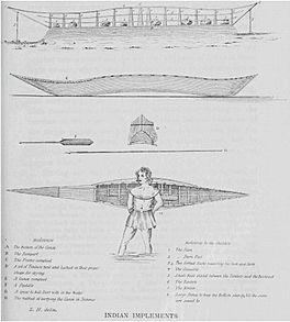
Illustration of canoe building at Lake Clowey (McArthur Lake), from Samuel Hearne's 1795 A Journey From Prince of Wales’s Fort in Hudson’s Bay to the Northern Ocean
|
|
| Location | Northwest Territories, Canada |
| Coordinates | 61°34′02″N 106°47′38″W / 61.567361°N 106.793764°W |
| Basin countries | Canada |
McArthur Lake, once called Clowey Lake, is a lake in the Northwest Territories of Canada. It is located on the Taltson River, east of Great Slave Lake. The lake sits just south of the area where trees stop growing, known as the tree line. Long ago, it might have been a busy place for building canoes.
Contents
Exploring McArthur Lake's Geography
McArthur Lake is about 250 kilometers (155 miles) north of Lake Athabasca. It is also about 200 kilometers (124 miles) east of Great Slave Lake. The lake stretches about 12 miles (19 kilometers) from east to west. A part of the lake in the south connects to Burpee Lake.
The lake is just south of the tree line, where the cold climate prevents trees from growing further north. The average temperature here is -8°C (18°F). July is the warmest month, with an average of 16°C (61°F). December is the coldest, averaging -25°C (-13°F).
Around the lake, you can find small groups of spruce and birch trees. There are also some jack pines. The lake is not very deep. This means strong winds can quickly create tall waves. Below the lake, there are many fast-moving rapids.
A Look into McArthur Lake's History
McArthur Lake is likely the same lake that explorer Samuel Hearne called "Clowey Lake." This area is part of the traditional lands of the Chipewyan people. Hearne left Prince of Wales Fort in December 1770. He traveled with a group of Chipewyan people. Their goal was to reach the Arctic Ocean by summer.
Hearne wrote about how the Dene people built canoes at Lake Clowey. It seems that Slavey and Dogrib Dene people often gathered here. They would come to build their canoes. The lake was given its current name on June 6, 1957. It honors Warrant Officer Edwin Matthew McArthur. He was part of the Royal Canadian Air Force. He died during World War II in 1943.
The Taltson River Basin
McArthur Lake is part of the Taltson River basin. This area has cool summers and very cold winters. The river basin covers about 11,486 square kilometers (4,435 square miles). This is the area upstream from Gray Lake.
The Taltson River starts near lakes like Coventry Lake. It also begins near Dymond Lake in the basin's northeast. The river flows north to McArthur Lake. Then it goes west to Gray Lake. From there, it flows to the southern shore of Great Slave Lake.
Fish in McArthur Lake
You can find different types of fish in McArthur Lake. Some of the fish found here include lake trout and lake whitefish.
 | Claudette Colvin |
 | Myrlie Evers-Williams |
 | Alberta Odell Jones |


