Prince of Wales Fort facts for kids
Quick facts for kids Prince of Wales Fort |
|
|---|---|
| Churchill, Manitoba, Canada | |

Prince of Wales Fort
|
|
| Coordinates | 58°47′49.77″N 94°12′48.34″W / 58.7971583°N 94.2134278°W |
| Type | Fortress |
| Site information | |
| Condition | Partially restored |
| Site history | |
| Built | 1717 (log fort) and 1731–1771 |
| In use | 1717–1782 |
| Battles/wars | Hudson Bay expedition (1782) |
| Official name: Prince of Wales Fort National Historic Site of Canada | |
| Designated: | 1920 |
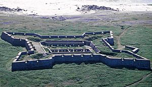
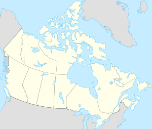
The Prince of Wales Fort is a large, historic stone fort located on Hudson Bay in Manitoba, Canada. It sits across the Churchill River from the town of Churchill. This fort was built like a star and played an important role in the early fur trade.
Contents
The Fort's Story
The story of Europeans in this area began in 1610 when Henry Hudson sailed into Hudson Bay. People soon realized this area was very important for the fur trade. It was also a good spot for new discoveries.
Building the First Fort
The very first fort here was made of logs. It was built in 1717 by James Knight, who worked for the Hudson's Bay Company (HBC). This first fort was called the Churchill River Post.
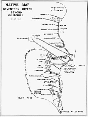
In 1719, its name was changed to Prince of Wales Fort. It was placed on the west side of the Churchill River. Its main job was to protect the HBC's business and control the valuable fur trade.
Building the Big Stone Fort
The original wooden fort was later replaced by a huge stone fort. This was likely done to follow a rule from the Royal Charter. This rule said that Rupert's Land, which was controlled by the HBC, needed to be protected with strong defenses.
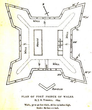
Construction of this new stone fort began in 1731. It was built near a place once called Eskimo Point. The fort was shaped like a square. Each side was about 90 meters (295 feet) long. Its walls were 6 meters (20 feet) tall and 9 meters (30 feet) thick at the bottom.
The fort had 42 cannons placed along its walls. There was also another small fort, called a battery, built across the river on Cape Merry. This battery was meant to hold six more cannons.
A Fort Without a Fight
In the 1780s, the French government sent an expedition to Hudson Bay. Their goal was to harm the Hudson's Bay Company's activities there. Three French warships, led by Jean-François de La Pérouse, arrived at the Prince of Wales Fort in 1782.
At that time, only 39 men were defending the fort. These men were not soldiers. The fort's governor, Samuel Hearne, saw that the French had many more soldiers and much stronger weapons. To avoid a fight and save lives, he surrendered the fort without firing a single shot. The French partly destroyed the fort. However, most of its ruins still stand today.
The fort was returned to the Hudson's Bay Company in 1783. After this, the fort became less important. The fur trade began to slow down, and a new trading post was set up further up the river.
What's Left of the Fort?
The remains of several buildings can still be seen inside the fort. None of them are complete, and their roofs fell apart a long time ago.
- Rough Stone Dwelling House
- Governor's Quarters
- Storehouse
- Men's Quarters and Barracks
- Stonemason's Workshop
- Cooper and Carpenter Workshops
- Tailor's Room
- Blacksmith Shop
The main courtyard inside the fort is still in good shape. All other open areas are covered by grass.
The Cape Merry Battery
Across the mouth of the Churchill River, opposite the fort, is the Cape Merry Battery. This battery was named after Captain John Merry, who was an important person in the Hudson's Bay Company. This fixed battery was built three times.
The first battery was built after 1718. It had a wall to protect cannons and a powder magazine (a place to store gunpowder). Only parts of the magazine's door and some wall sections remain. A second battery was built in 1747, further away from the river. This was because people worried the first battery could be used to attack the main fort. A third battery was rebuilt in 1959-1960, restoring the second one. Today, the battery has one cannon.
Bringing the Fort Back to Life
After the Hudson Bay Railway was finished in Churchill in 1929, workers and equipment from the railway helped restore the fort. More restoration work was done in the late 1950s.
Archaeologists, who study old things, began exploring the fort and the area around it in 1958. Since 2005, Parks Canada archaeologists have been working at the fort. They are helping to make the walls stable and to create programs that explain the fort's history to visitors.
Why the Fort is Important Today
In 1920, the Prince of Wales Fort was named a National Historic Site of Canada. This means it is a very important place in Canada's history.
Journals written by explorer Samuel Hearne about his journey from Prince of Wales Fort were published in 1911. On June 28, 1985, Canada Post released a stamp featuring 'Fort Prince of Wales, Man.' It was part of a series called "Forts Across Canada." The fort is also featured in one of the National Film Board of Canada's short films called Canada Vignettes.
 | James B. Knighten |
 | Azellia White |
 | Willa Brown |


