
Churchill River (Hudson Bay) facts for kids
Quick facts for kids Churchill River |
|
|---|---|

Otter Rapids (Churchill River)
|
|

Churchill River Basin in Canada
|
|
| Native name | Missinipi |
| Country | Canada |
| Provinces | |
| Physical characteristics | |
| Main source | Churchill Lake Saskatchewan 56°6′22″N 108°14′46″W / 56.10611°N 108.24611°W |
| River mouth | Hudson Bay Manitoba 58°47′45″N 94°12′15″W / 58.79583°N 94.20417°W |
| Length | 1,609 km (1,000 mi) |
| Basin features | |
| Basin size | 281,300 km2 (108,600 sq mi) |
The Churchill River (in French, Rivière Churchill) is a very important river in Canada. It flows through Alberta, Saskatchewan, and Manitoba. The river is about 1,609 kilometers (1,000 miles) long, starting from Churchill Lake.
It was named after John Churchill, 1st Duke of Marlborough. He was a governor of the Hudson's Bay Company a long time ago, from 1685 to 1691. The Cree people, who are First Nations people, call the river Missinipi. This name means "big waters."
The Churchill River is completely located within the Canadian Shield. This is a huge area of ancient rock. Many lakes in central-east Alberta flow into a series of lakes in Saskatchewan and Manitoba, forming the river's path. The main river that flows into the Churchill is the Beaver River. It joins the Churchill at a place called Lac Île-à-la-Crosse.
Nistowiak Falls are the tallest waterfalls in Saskatchewan. They are on the Rapid River. This river flows north from Lac la Ronge into Nistowiak Lake, which is part of the Churchill River system.
A lot of the water in the Churchill River, especially after it crosses into Manitoba, comes from the Reindeer River. This river flows from Wollaston and Reindeer lakes. The amount of water flowing from Reindeer Lake is controlled by the Whitesand Dam.
From there, the Churchill River flows east through several lakes. These include Highrock, Granville, Southern Indian, and Gauer. Part of the river's flow is then sent into the Nelson River to create electricity. The rest of the water continues as the Churchill River and flows into Hudson Bay at Churchill, Manitoba.
Contents
History of the Churchill River
The Churchill River was a very important route for travelers and traders a long time ago. From the 1700s to the 1900s, it was like a "highway" for voyageurs. These were French-Canadian travelers who transported furs by canoe.
Dene people, another First Nations group, showed a fur trader named Peter Pond a special path. This path was called the Methye Portage. It connected the Churchill River, which flows to Hudson Bay, with other rivers like the Clearwater, Athabasca, and MacKenzie. These rivers flow all the way to the Arctic Ocean. This connection made the Churchill River a key part of early Canadian canoe routes.
Fish Species in the River
The Churchill River is home to many different kinds of fish. If you like fishing, you might find:
- Walleye
- Sauger
- Yellow perch
- Northern pike
- Lake trout
- Lake whitefish
- Cisco
- White sucker
- Shorthead redhorse
- Longnose sucker
- Lake sturgeon
- Burbot
Hydroelectric Power Projects
Hydroelectric power is electricity made from moving water. The Churchill River has been used for this purpose.
Island Falls Power Station
The only power station currently working on the Churchill River is called Island Falls. It can produce 111 megawatts (MW) of electricity. The Whitesand Dam, which we mentioned earlier, helps control the water flow to Island Falls. This is because the power station is located downstream from where the Reindeer River joins the Churchill.
Wintego Hydroelectric Project
In the 1970s, a company called SaskPower thought about building another power station. It would have been called Wintego. This station would have been about 14 kilometers (9 miles) downstream from the Reindeer River and 20 miles (32 kilometers) upstream from Island Falls.
The Wintego project was expected to cost a lot of money, around $338 million back then. Today, that would be like $1.3 billion! It was planned to produce 300 MW of power. Building Wintego would also have helped Island Falls produce an extra 70 MW of power. However, the project was never built.
Other Potential Power Stations
There were also ideas for two other power stations in Saskatchewan, between the Reindeer River and Island Falls. These were called the Iskwatam Generating Station and the Pita Generating Station. Their exact power capacities are not known.
In Manitoba, there were plans for two more power stations: Bonald and Granville Falls. Bonald could have produced 110 MW, and Granville Falls could have produced 120 MW.
Images for kids
-
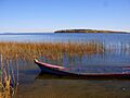
Churchill Lake viewed from Buffalo Narrows
-
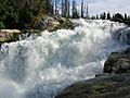
View of upper Nistowiak Falls
-
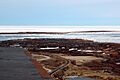
Mouth of the Churchill River at Hudson Bay
-

Watching belugas is a popular attraction at the river mouth.
-

Mouth of the Churchill River at Hudson Bay


.jpg)
See also
 In Spanish: Río Churchill para niños
