
Nistowiak Falls facts for kids
Quick facts for kids Nistowiak Falls |
|
|---|---|
 |
|
| Lua error in Module:Infobox_mapframe at line 185: attempt to index field 'wikibase' (a nil value). | |
| Coordinates | 55°24′00″N 104°22′02″W / 55.40°N 104.3671°W |
| Type | Cataract |
| Total height | 10 metres (33 ft) |
| Watercourse | Rapid River |

Nistowiak Falls is a tall and beautiful waterfall in Saskatchewan, Canada. It drops about 10 metres (33 ft), making it one of the highest waterfalls in the province. The falls are found on the Rapid River. This river flows north from Iskwatikan Lake into Nistowiak Lake. Both lakes are part of the larger Churchill River system. The name "Nistowiak" comes from the Cree language. It means "the meeting of waters," which perfectly describes this spot.
Getting to Nistowiak Falls
Reaching Nistowiak Falls is an adventure! The closest place to start your trip is Stanley Mission. This is a community that is part of the La Ronge Indian Band. Stanley Mission is located at the end of Highway 915. You can reach Highway 915 by taking Highway 102 from La Ronge.
Once you are in Stanley Mission, you will travel by water. The falls are about 20 kilometres (12 mi) east from Stanley Mission. You will travel along the Churchill River to get there.
Exploring the Area Around the Falls
Nistowiak Falls is located inside Lac La Ronge Provincial Park. This park protects the natural beauty of the area. The falls themselves are within the park boundaries. Iskwatikan Lake and the southern shore of Nistowiak Lake are also part of the park.
There is a small fishing camp near the falls. It is called "Jim's Camp" and is on the west side of the Rapid River. You might be able to get a few basic supplies there. The path to the falls actually goes right through this fishing camp. The water from Lac la Ronge eventually flows into the Churchill River through these impressive falls.
Images for kids
-
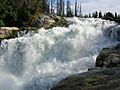
View of upper Nistowiak Falls
-
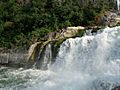
View of lower reaches of Nistowiak Falls

