Red Coat Trail facts for kids
Quick facts for kids
Red Coat Trail |
|
|---|---|

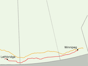
Red Coat Trail marked in red and the Trans-Canada Highway marked in yellow
|
|
| Route information | |
| Length | 1,280.1 km (795.4 mi) |
| Component highways |
AB 3, AB 4, AB 61, AB 889, AB 501, SK 13, MB 2 |
| Major junctions | |
| West end | |
|
|
| East end | |
| Highway system | |
| Provincial highways in Alberta Provincial highways in Saskatchewan Manitoba provincial highways |
|
The Red Coat Trail is a long route, about 1,300 kilometers (800 miles) across Western Canada. It follows the path that the North-West Mounted Police (NWMP) took in 1874. They were moving west to bring law and order to the Canadian Prairies.
Contents
Exploring the Red Coat Trail Today
Many highways in southern Manitoba, Saskatchewan, and Alberta roughly follow the original Red Coat Trail. This lets you drive along a historic route!
In Alberta, the trail uses parts of Highways 3, 4, 61, 889, and 501. In Saskatchewan, Highway 13 is officially called the Red Coat Trail. When you get to Manitoba, Manitoba PTH 2 continues the journey towards Winnipeg.
Alberta's Historic Path
Near Fort Macleod, the trail is quite busy, with thousands of vehicles using it daily. This area is a short grass prairie, perfect for growing grain. Fort Macleod is an important town where Highway 2 meets the Red Coat Trail. It has over 3,000 people. A big attraction nearby is Head-Smashed-In Buffalo Jump, a UNESCO World Heritage site about 20 kilometers (12 miles) northwest of town.
Between Fort Macleod and Lethbridge, the Red Coat Trail joins the Crowsnest Highway. You'll pass through rolling hills and open plains. The land here was shaped by glaciers thousands of years ago. North of the highway, you can see the huge CP Rail High Level trestle bridge, built in 1909. Today, there are trails in the river valley nearby.
As you get closer to Lethbridge, the highway gets wider. This area is known for farming, especially oil, flax, wheat, and sugar beets. Lethbridge is a major city where several highways meet. From Lethbridge, the Red Coat Trail continues southeast on Highway 4 towards Stirling.
After Stirling, the trail turns east onto Highway 61. This road takes you through smaller communities like Wrentham and Skiff. The landscape changes to a drier grassland area. You might also find interesting places like the Etzikom Museum and the Canadian National Historical Windmill Center in Etzikom. The trail continues to Manyberries and then on smaller highways towards the Saskatchewan border.
Saskatchewan's Red Coat Journey
Saskatchewan's part of the Red Coat Trail is about 676 kilometers (420 miles) long. There are many small towns along the way, about every 20 kilometers (12 miles).
As you enter Saskatchewan, the road might be gravel at first. Soon, it becomes a paved highway, SK Highway 13, which is the main part of the Red Coat Trail in this province. You can take a side trip north on SK Highway 615 to visit Fort Walsh National Historic Park, which is also the highest point in Saskatchewan.
Further east, near Eastend, you'll find the "Dino Country." This is where a Tyrannosaurus rex fossil was discovered, leading to the T. rex Discovery Centre. Southern Saskatchewan is famous for its ancient animal fossils. The road here gets busier and is well-paved.
The trail continues through rolling hills and grasslands. You'll pass through towns like Shaunavon and Lafleche. Near Lafleche, you can visit Thomson Lake, a man-made lake that was Saskatchewan's first regional park.
The Red Coat Trail eventually reaches Assiniboia, where it meets SK Highway 2. The traffic here increases, showing how important this route is.
Next, the trail leads to Weyburn, a city known as the "Soo Line City" because of its railway connections to Chicago. Weyburn is also located in an area with oil deposits. You can see roadside attractions like a lighthouse water tower here. The Souris River, a long river that flows into Manitoba, is also nearby.
East of Weyburn, the Red Coat Trail is mostly paved. It passes through Stoughton and then reaches Carlyle. Carlyle is at the intersection with SK Highway 9, which can take you north to Moose Mountain Provincial Park. The trail continues as a paved or gravel road until you reach the Manitoba border. Along the way, you'll pass through small communities like Manor and Redvers.
Manitoba's Final Stretch
In Manitoba, the Red Coat Trail follows Manitoba PTH 2. This part of the trail is about 349 kilometers (217 miles) long and has 19 communities along it.
It's important to know that the actual path the North-West Mounted Police took in 1874 was about 100 kilometers (60 miles) south of the modern "Red Coat Trail" that tourists follow. The Manitoba government doesn't officially use the "Red Coat Trail" name for its highways. Still, it's a great way to experience the general area where the Mounties traveled.
The History of the Red Coat Trail
Early Travel and Road Building
The Red Coat Trail follows the path of the North-West Mounted Police (NWMP) in 1874. Before roads, travelers used trails made by Indigenous peoples and fur traders. In the 1800s, much of what is now farmland was forested or marshy.
As settlers arrived, they began to clear land for farms. Surveyors marked out "road allowances" – strips of land set aside for future roads. Local communities then started building these roads. Early road work was done with simple tools like plows pulled by horses and scrapers called "fresnoes." People who worked on the roads could get lower taxes. Later, bigger equipment like four-horse scrapers and tractors were used.
Crossing rivers was a challenge. People used ferries, which were like small boats, to get across. Around 1890, the first highway bridge piers were built across the Belly River. The first car in Alberta appeared in 1901! These early cars had high wheels and could travel on rough trails.
Improving Roads and Bridges
In the early 1900s, cities like Lethbridge faced floods that could wash away houses and bridges. After a big flood in 1902, a strong steel bridge was built over the Oldman River. North of the Red Coat Trail, the huge Canadian Pacific Railway (CPR) trestle bridge was built between 1908 and 1909. It's over 576 meters (1,891 feet) long and 45 meters (150 feet) high!
By 1910, people were pushing for better roads. The speed limit for cars was about 40 kilometers per hour (25 miles per hour). Many people still traveled by horse or train. In 1912, a special board was created to give money for road improvements.
In the 1920s, roads started to be covered with gravel. This helped cars avoid getting stuck in mud. However, gravel roads could be dusty in dry weather. To fix this, workers mixed clay with the gravel. Road work continued even during the Great Depression in the 1930s, making highways wider, gravelled, and eventually paved.
After World War II, rural communities got better equipment like tractors and graders. By 1949, the old steel bridge in Lethbridge was replaced. In the 1960s, gravel highways were oiled to reduce dust. In the 1970s, SK Highway 13 was extended and paved to handle heavy loads from mining.
The North-West Mounted Police Journey
The idea for the North-West Mounted Police was created in 1873. Men were recruited and trained in Manitoba. On July 8, 1874, these trained officers began their long journey west. They were called "Red Coats" because of their bright red uniforms.
One of their main goals was to stop illegal whisky trading and bring law to the wild west. They established posts like Fort Macleod, where you can still visit a museum and the old NWMP Barracks Site. Another important post was Wood Mountain, set up in 1874.
After the Battle of Little Bighorn in 1876, the famous Sitting Bull and his followers came to the Wood Mountain area seeking safety. NWMP officers, like Superintendent James Walsh, met with Sitting Bull. The NWMP helped keep peace in the area.
The town of Redvers, along the Red Coat Trail, is named after Sir Redvers Buller, a famous British General. The Red Coat Trail reminds us of the brave journey these early police officers made to shape Western Canada.
Images for kids
 | Victor J. Glover |
 | Yvonne Cagle |
 | Jeanette Epps |
 | Bernard A. Harris Jr. |


