Wrentham, Alberta facts for kids
Quick facts for kids
Wrentham
|
|
|---|---|
|
Hamlet
|
|

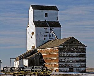
Grain elevator in Wrentham
|
|
| Motto(s):
Come Enjoy Wrentham
|
|
| Country | Canada |
| Province | Alberta |
| Region | Southern Alberta |
| Census division | 2 |
| Municipal district | County of Warner No. 5 |
| Founded | 1910 |
| Incorporated | 1913 |
| Government | |
| • Type | Unincorporated |
| Elevation | 946 m (3,104 ft) |
| Population
(1991)
|
|
| • Total | 58 |
| Time zone | UTC−7 (MST) |
| • Summer (DST) | UTC−6 (MDT) |
| Postal code span |
T0K 2P0
|
| Area code(s) | +1-403 |
| Highways | Highway 61 |
| Waterways | Chin Reservoir |
Wrentham is a small community called a hamlet in southern Alberta, Canada. It is part of the County of Warner No. 5. You can find it southeast of where two important roads meet: the Veteran Memorial Highway (Highway 36) and the old Red Coat Trail (Highway 61).
Wrentham is about 25 kilometers (15 miles) east of Stirling. It's also about 30 kilometers (19 miles) south of Taber. If you travel west, it's about 55 kilometers (34 miles) from Foremost.
History and Naming
Wrentham got its name from the Canadian Pacific Railway. They named it after another place called Wrentham. That original village is in Suffolk, England. The community was founded in 1910 and officially became a hamlet in 1913.
Location and Government
Wrentham is located in what is known as Census Division No. 2. This helps Statistics Canada count people and gather information. The hamlet is governed by the County of Warner No. 5 Council. This council helps make decisions for the area.
Population Information
In the year 1991, Statistics Canada counted the number of people living in Wrentham. The 1991 Census of Population showed that 58 people lived in the hamlet at that time.
 | Janet Taylor Pickett |
 | Synthia Saint James |
 | Howardena Pindell |
 | Faith Ringgold |


