
Gunnison, Utah facts for kids
Quick facts for kids
Gunnison, Utah
|
|
|---|---|

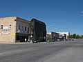
Looking south down Gunnison's Main Street (US-89), June 2005
|
|

Location in Sanpete County and the state of Utah.
|
|
| Country | United States |
| State | Utah |
| County | Sanpete |
| Founded | 1859 |
| Named for | John Williams Gunnison |
| Area | |
| • Total | 4.79 sq mi (12.40 km2) |
| • Land | 4.79 sq mi (12.40 km2) |
| • Water | 0.00 sq mi (0.00 km2) |
| Elevation | 5,138 ft (1,566 m) |
| Population
(2020)
|
|
| • Total | 3,509 |
| • Density | 732.57/sq mi (282.85/km2) |
| Time zone | UTC-7 (Mountain (MST)) |
| • Summer (DST) | UTC-6 (MDT) |
| ZIP code |
84634
|
| Area code(s) | 435 |
| FIPS code | 49-32660 |
| GNIS feature ID | 1428432 |
Gunnison is a city in the Sevier Valley located in southwestern Sanpete County, Utah, United States. In 2020, about 3,509 people lived there. The city was named after John W. Gunnison, an officer from the United States Army. He explored the area in 1853 while looking for a good path for a transcontinental railroad.
Contents
History
Gas Leak Incident
In the summer of 2007, a large amount of gasoline, over 24,000 gallons (about 90,850 liters), leaked from a storage tank at a gas station. This gasoline spread through the soil under Main Street and into some parts of the town. It affected businesses and homes.
Because of the gasoline fumes, officials asked people to temporarily leave a block of Main Street in August 2007. Special systems were put in place underground to help clean up the soil. Some businesses had to close permanently, and some homes were evacuated. The city and some residents worked to clean up the area. The cleanup was expected to take many years.
Geography
Gunnison is located in Utah. According to the United States Census Bureau, the city covers an area of about 5.3 square miles (13.7 square kilometers). All of this area is land.
| Historical population | |||
|---|---|---|---|
| Census | Pop. | %± | |
| 1870 | 475 | — | |
| 1880 | 729 | 53.5% | |
| 1890 | 845 | 15.9% | |
| 1900 | 829 | −1.9% | |
| 1910 | 950 | 14.6% | |
| 1920 | 1,115 | 17.4% | |
| 1930 | 1,057 | −5.2% | |
| 1940 | 1,115 | 5.5% | |
| 1950 | 1,144 | 2.6% | |
| 1960 | 1,059 | −7.4% | |
| 1970 | 1,073 | 1.3% | |
| 1980 | 1,255 | 17.0% | |
| 1990 | 1,298 | 3.4% | |
| 2000 | 2,394 | 84.4% | |
| 2010 | 3,285 | 37.2% | |
| 2020 | 3,509 | 6.8% | |
| U.S. Decennial Census | |||
Population Information
How Many People Live Here?
Based on the census from 2000, there were 2,394 people living in Gunnison. There were 513 households, and 410 of these were families. The city had about 452 people per square mile (174.4 per square kilometer).
Most people in Gunnison were White (88.35%). There were also smaller groups of African American, Native American, Asian, and Pacific Islander residents. About 7.10% of the population identified as Hispanic or Latino.
Age and Households
In 2000, about 45.2% of households had children under 18 living with them. Most households (72.1%) were married couples living together. The average household had about 3.12 people.
The population was spread out by age:
- 25.3% were under 18 years old.
- 13.2% were between 18 and 24.
- 33.8% were between 25 and 44.
- 17.9% were between 45 and 64.
- 9.7% were 65 years or older.
The average age in the city was 32 years. There is a state-run prison nearby called the Central Utah Correctional Facility. It opened in 1990 and houses only male offenders. This facility affects the population numbers in the city.
Education
Gunnison is part of the South Sanpete School District. The city has one elementary school, one middle school, and one high school. All these schools are known as Gunnison Valley schools, with the high school being Gunnison Valley High School.
Images for kids
-
Looking north along the west side of Main Street (US-89) in Gunnison, September 2010

See also
 In Spanish: Gunnison (Utah) para niños
