Sevier, Utah facts for kids
Quick facts for kids
Sevier
|
|
|---|---|

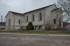
The old Sevier Ward Church, April 2010
|
|
| Country | United States |
| State | Utah |
| County | Sevier |
| Elevation | 5,584 ft (1,702 m) |
| Time zone | UTC-7 (Mountain (MST)) |
| • Summer (DST) | UTC-6 (MDT) |
| ZIP codes |
84766
|
| Area code(s) | 435 |
| GNIS feature ID | 1445446 |
Sevier (/sɛˈvɪər/ SƏ-veer) is a small community in southwestern Sevier County, Utah, United States. It is known as an "unincorporated community." This means it does not have its own local government like a city or town. Instead, it is managed as part of the larger county. Sevier is located in the valley of the Sevier River. It lies along Sevier Highway, which used to be part of U.S. Route 89. The community is southwest of Richfield, the main city and county seat of Sevier County. Sevier sits at an elevation of about 5,584 feet (1,702 meters) above sea level.
Life in Sevier
Sevier might be a small community, but it has its own post office. This post office uses the ZIP code 84766. The community has a population of around 80 people. Many residents in Sevier work on farms. These farms mainly grow a plant called alfalfa, which is used to feed animals.
Population Changes
Over the years, Sevier has seen its population change. During the 1990s and 2000s, the number of people living there grew. This growth was partly due to seasonal workers. These workers, often from Mexico and other Hispanic countries, came to help with farm work. They helped the community's population become more diverse and active throughout the year.
Climate and Weather
Sevier experiences a type of weather known as a humid continental climate. This means the area has big differences in temperature between seasons. Summers in Sevier are usually warm to hot. They can sometimes feel humid. Winters, on the other hand, are cold, and can even be very cold at times. This climate type is often shown as "Dfb" on climate maps.
 | Mary Eliza Mahoney |
 | Susie King Taylor |
 | Ida Gray |
 | Eliza Ann Grier |


