San Pitch River facts for kids
Quick facts for kids San Pitch River |
|
|---|---|

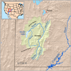
The San Pitch is to the east of the Great Basin section but within the Great Basin (west of the Great Basin Divide).
|
|
| Native name | Sahpeech (Ute) |
| Other name(s) | "SanPitch" |
| Country | United States |
| State | Utah |
| Physical characteristics | |
| Length | 65 mi (105 km) |
| Basin features | |
| River system | Escalante-Sevier subregion |
| Basin size | 480 sq mi (1,200 km2) |
The San Pitch River is an important river in Utah, United States. It flows for about 65 mi (105 km) (105 km). This river is the main waterway in the Sanpete Valley. It eventually flows into the Sevier River in the southwestern part of Sanpete County.
The river gets its name from a Ute chief named Sanpitch. Many other places in the area are also named after him, including the San Pitch Mountains and Sanpete County.
River's Journey
The San Pitch River starts its journey in the northern Wasatch Plateau. This area is near Oak Creek Ridge, north of a town called Milburn. From there, the river flows south towards Moroni.
Middle Section
The middle part of the San Pitch River begins in Moroni. Here, it crosses Utah State Route 132 (SR‑132). This section of the river continues until it reaches the Gunnison Reservoir.
Final Stretch
The lower part of the San Pitch River flows out of the Gunnison Reservoir. It continues its path until it joins the Sevier River. This meeting point is located west of the town of Gunnison.
 | Calvin Brent |
 | Walter T. Bailey |
 | Martha Cassell Thompson |
 | Alberta Jeannette Cassell |

