Beaver River (Utah) facts for kids
Quick facts for kids Beaver River (Utah) |
|
|---|---|

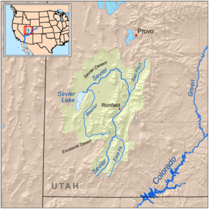
Map of the Sevier River system, including the Beaver River
|
|
| Country | United States |
| State | Utah |
| Physical characteristics | |
| Main source | Confluence of South and East Forks Tushar Mountains, Beaver County 7,142 ft (2,177 m) 38°16′57″N 112°26′50″W / 38.28250°N 112.44722°W |
| River mouth | Sevier River near Delta, Millard County 4,557 ft (1,389 m) 39°09′11″N 112°50′06″W / 39.15306°N 112.83500°W |
| Length | 110 mi (180 km) |
| Basin features | |
| Basin size | 2,466 sq mi (6,390 km2) |
| Tributaries |
|
The Beaver River is a river in western Utah, United States. It flows for about 110 miles (180 km) (177 km). This river is an important part of the Sevier River system. It eventually drains into Sevier Lake.
Contents
Where Does the Beaver River Start?
The Beaver River begins high up in the Tushar Mountains. This mountain range is located in eastern Beaver County. The river starts near the town of Beaver.
The River's Journey West
For about 30 miles (48 km) (48 km), the Beaver River flows west. During this part of its journey, it is a perennial stream. This means it flows all year round. It passes through the beautiful Beaver Valley. Then it reaches the Escalante Desert.
Turning North and Becoming Ephemeral
After the Escalante Desert, the river changes direction. It turns and flows north. For about 80 miles (130 km) (129 km), it continues its journey. In this section, the river becomes an ephemeral wash. This means it only flows after heavy rain or snowmelt. It passes by the town of Milford. Then it enters Millard County.
Reaching Its End
The Beaver River eventually reaches the Sevier Desert. This is south of the town of Delta. Here, it turns west one last time. It then joins the larger Sevier River. Finally, the water from the Beaver River empties into the Sevier Lake. Sevier Lake is a special type of lake called an endorheic basin. This means water flows into it, but no water flows out. The lake often dries up, making it intermittent.
The Beaver River Watershed
The area of land that drains into the Beaver River is called its watershed. This watershed covers about 2,466 square miles (6,390 km2) (6,387 km²). Most of this land is desert.
People and Farming Along the River
About 3,500 people live in the Beaver River watershed. Most of these people live in the town of Beaver. The river is very important for farming in the area. Farmers use its water to grow crops.
How Water is Stored
To help with farming, the river's water is stored. The Rocky Ford Dam was built on the upper part of the river. This dam creates Minersville Reservoir. This reservoir holds water for irrigation. About 84,000 acres (34,000 ha) (34,000 hectares) of land are farmed in the river basin.
 | John T. Biggers |
 | Thomas Blackshear |
 | Mark Bradford |
 | Beverly Buchanan |

