
Millard County, Utah facts for kids
Quick facts for kids
Millard County
|
|
|---|---|

Old Millard County courthouse
|
|

Location within the U.S. state of Utah
|
|
 Utah's location within the U.S. |
|
| Country | |
| State | |
| Founded | October 4, 1851 |
| Named for | Millard Fillmore |
| Seat | Fillmore |
| Largest city | Delta |
| Area | |
| • Total | 6,828 sq mi (17,680 km2) |
| • Land | 6,572 sq mi (17,020 km2) |
| • Water | 255 sq mi (660 km2) 3.7% |
| Population
(2020)
|
|
| • Total | 12,975 |
| • Estimate
(2023)
|
13,437 |
| • Density | 1.90026/sq mi (0.73370/km2) |
| Time zone | UTC−7 (Mountain) |
| • Summer (DST) | UTC−6 (MDT) |
| Congressional district | 2nd |
Millard County is a county located in the state of Utah in the United States. In 2020, about 12,975 people lived here. The main town and county seat is Fillmore. The biggest city in the county is Delta.
Contents
History of Millard County
The Utah Territory government created Millard County on October 4, 1851. It was named after Millard Fillmore, who was the 13th President of the United States at that time. Fillmore was chosen as the county seat.
Fillmore was first planned to be the capital of the Utah Territory. In 1851, Governor Brigham Young picked the exact spot for the town. People soon moved there and built homes, a mill for grinding grain, and a sawmill. Construction of the Territorial Statehouse began in 1852. The territory's lawmakers met in Fillmore only once, in 1855. The next year, they decided to move the capital to Great Salt Lake City.
Geography of Millard County
Millard County is on the western side of Utah. Its western border touches the state of Nevada. The county has dry, flat lands with many hills and mountains. The highest point is Mine Camp Peak, which is 10,222 feet (3,116 meters) high. The county covers a total area of 6,828 square miles (17,684 square kilometers). Most of this is land, with a small part being water. It is the third-largest county in Utah by size.
The Sevier Desert covers much of Millard County. This area used to be the bottom of an ancient lake called Lake Bonneville. Sevier Lake, which is mostly dry now, is in the middle of the county. The Pahvant Mountains are along the county's eastern edge. Towns like Fillmore and other farming areas are located at the base of these mountains. Delta is near the Sevier River in the center of the basin.
Main Roads
- Interstate 15
- Interstate 70
- US-6
- US-50
- SR-21
- SR-100
- SR-125
- SR-132
- SR-133
- SR-136
- SR-257
Neighboring Counties
- Juab County - north
- Sanpete County - northeast
- Sevier County - southeast
- Beaver County - south
- Lincoln County, Nevada - southwest
- White Pine County, Nevada - west
Protected Natural Areas
- Circus Hollow Wildlife Management Area
- Clear Lake Waterfowl Management Area
- Fishlake National Forest (part)
- Halfway Hill Wildlife Management Area
Cool Places to See
Millard County has some interesting natural features.
The Great Stone Face

In the Pahvant Valley, there are old lava flows and volcanoes. One cool spot is called the "Great Stone Face." It's a rock formation that looks like a person's face from certain angles. It stands about four stories tall! Nearby, there's a large rock covered with ancient Native American drawings called petroglyphs.
Notch Peak
Notch Peak is a mountain about 50 miles (80 km) west of Delta. When you look at it from Delta, it seems like a piece has been cut out of its top, like a "notch."
Little Sahara Sand Dunes
Little Sahara Recreation Area is about 25 miles (40 km) north of Delta. It's a popular place for people who like to ride ATVs (all-terrain vehicles) on the sand dunes.
People of Millard County
| Historical population | |||
|---|---|---|---|
| Census | Pop. | %± | |
| 1860 | 715 | — | |
| 1870 | 2,753 | 285.0% | |
| 1880 | 3,727 | 35.4% | |
| 1890 | 4,033 | 8.2% | |
| 1900 | 5,678 | 40.8% | |
| 1910 | 6,118 | 7.7% | |
| 1920 | 9,659 | 57.9% | |
| 1930 | 9,945 | 3.0% | |
| 1940 | 9,613 | −3.3% | |
| 1950 | 9,387 | −2.4% | |
| 1960 | 7,866 | −16.2% | |
| 1970 | 6,988 | −11.2% | |
| 1980 | 8,970 | 28.4% | |
| 1990 | 11,333 | 26.3% | |
| 2000 | 12,405 | 9.5% | |
| 2010 | 12,503 | 0.8% | |
| 2020 | 12,975 | 3.8% | |
| 2023 (est.) | 13,437 | 7.5% | |
| US Decennial Census 1790–1960 1900–1990 1990–2000 2010 2020 |
|||
In 2020, there were 12,975 people living in Millard County. This means there were about 1.9 people per square mile. The population was almost evenly split between males and females. About 31% of the people were under 18 years old. The average age of people in the county was 36.1 years.
There were about 4,299 households in the county. Most of these were families, and many had children under 18. Most homes were owned by the people living in them.
Economy
Millard County is working to support new ways of building homes. They are making it easier to build Earthships and straw bale homes. These types of homes are designed to be good for the environment.
The county is also home to the Telescope Array Project. This is a special observatory that studies very high-energy cosmic rays from space.
Japanese Internment Camp
The Topaz War Relocation Center was a camp located in Millard County. It was used during World War II to hold Japanese Americans. The camp is about 15 miles (24 km) west of Delta. Today, you can visit the site, and there is a memorial there.
Communities in Millard County

Millard County has several cities, towns, and smaller communities.
Cities
Towns
Census-Designated Places
Unincorporated Communities
- Abraham
- Black Rock
- Border
- Burbank
- Cove Fort
- EskDale
- Flowell
- Fool Creek
- Gandy
- Garrison
- Hatton
- McCornick
- Sugarville
- Woodrow
Former Communities
- Bloom
- Borden
- Clear Lake
- Greenwood
- Ibex
- Sunflower
- Topaz
- Van
Education
The schools in Millard County are part of the Millard School District.
Gallery
-
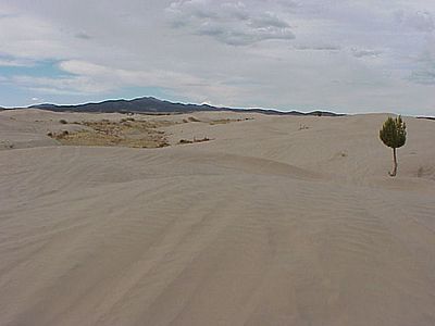
Little Sahara Sand Dunes
-
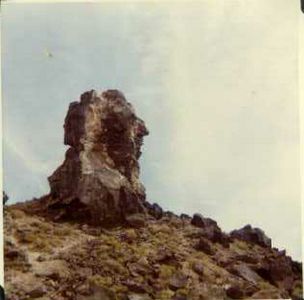
The Great Stone Face
-
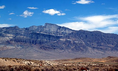
Notch Peak as seen from the valley floor
-
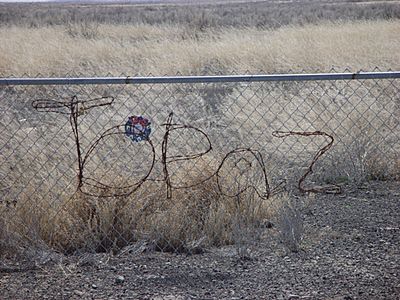
Topaz Internment Camp memorial


See also
 In Spanish: Condado de Millard para niños
