Beaver County, Utah facts for kids
Quick facts for kids
Beaver County
|
|
|---|---|

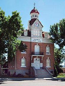
Old Beaver County courthouse.
|
|

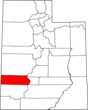
Location within the U.S. state of Utah
|
|
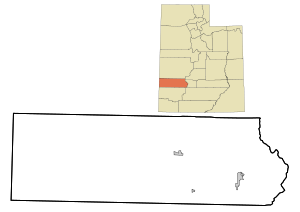
 Utah's location within the U.S. |
|
| Country | |
| State | |
| Founded | 1856 |
| Named for | North American beaver |
| Seat | Beaver |
| Largest city | Beaver |
| Area | |
| • Total | 2,592 sq mi (6,710 km2) |
| • Land | 2,590 sq mi (6,700 km2) |
| • Water | 2.1 sq mi (5 km2) 0.08% |
| Population
(2020)
|
|
| • Total | 7,072 |
| • Estimate
(2023)
|
7,233 |
| • Density | 2.7284/sq mi (1.05344/km2) |
| Time zone | UTC−7 (Mountain) |
| • Summer (DST) | UTC−6 (MDT) |
| Congressional district | 2nd |
Beaver County is a county located in west-central Utah, United States. In 2020, about 7,072 people lived there. This was an increase from 6,629 people in 2010. The main city and county seat is Beaver. The county got its name because there were many beavers in the area.
Contents
History of Beaver County
Explorers from Europe first visited the area that is now Beaver County in 1776. This was part of the Dominguez–Escalante Expedition. Later, in 1847, Mormon pioneers arrived in Utah. They settled the area around Great Salt Lake City first. Then, they started moving into other parts of Utah, including the future Beaver County.
Beaver County was officially created on January 5, 1856. This was done by the government of the Utah Territory. It was formed from a part of Iron County. The town of Beaver was founded later that same year. The county was named after the many beavers found in its rivers and streams.
Geography of Beaver County
Beaver County is on the western side of Utah. Its western border touches the state of Nevada. The western part of the county has low, rolling hills. You can also see some mountains standing alone there. The eastern edge of the county reaches the top of a long mountain range.
The land generally slopes downwards to the west and north. The highest point in the county is a mountain peak on its eastern border. This peak is about 12,011 feet (3,661 meters) above sea level. The county covers a total area of about 2,592 square miles (6,713 km²). Most of this area, about 2,590 square miles (6,708 km²), is land. Only a small part, about 2.1 square miles (5.4 km²), is water.
The Tushar Mountains are on the eastern side of the county. These mountains are very tall, reaching up to 12,000 feet (3,658 meters). They provide water for farming towns like Beaver and Manderfield. To the west, you will find dry desert valleys. These valleys are separated by mountains with light forests of juniper trees.
Neighboring Counties
- Lincoln County, Nevada - west
- Millard County - north
- Sevier County - northeast
- Piute County - east
- Garfield County - southeast
- Iron County - south
Protected Natural Areas
- Fishlake National Forest (part of it is in Beaver County)
- Indian Peak State Game Management Area
- Minersville National Forest (part of it is in Beaver County)
Population of Beaver County
| Historical population | |||
|---|---|---|---|
| Census | Pop. | %± | |
| 1860 | 785 | — | |
| 1870 | 2,007 | 155.7% | |
| 1880 | 3,918 | 95.2% | |
| 1890 | 3,340 | −14.8% | |
| 1900 | 3,613 | 8.2% | |
| 1910 | 4,717 | 30.6% | |
| 1920 | 5,139 | 8.9% | |
| 1930 | 5,136 | −0.1% | |
| 1940 | 5,014 | −2.4% | |
| 1950 | 4,856 | −3.2% | |
| 1960 | 4,331 | −10.8% | |
| 1970 | 3,800 | −12.3% | |
| 1980 | 4,378 | 15.2% | |
| 1990 | 4,765 | 8.8% | |
| 2000 | 6,005 | 26.0% | |
| 2010 | 6,629 | 10.4% | |
| 2020 | 7,072 | 6.7% | |
| 2023 (est.) | 7,233 | 9.1% | |
| US Decennial Census 1790–1960 1900–1990 1990–2000 2010–2018 2019 2020 |
|||
In 2020, the 2020 United States census counted 7,072 people living in Beaver County. This means there were about 2.7 people for every square mile. Most people in the county are White. About 15% of the people are Hispanic or Latino.
The population is made up of slightly more males than females. About 30% of the people are under 18 years old. The average age in Beaver County is about 34.4 years.
There are about 2,276 households in the county. Most of these, about 74%, are families. About 60% of families are married couples. Most households, about 75%, own their homes.
Communities in Beaver County
Cities
Towns
Unincorporated Communities
These are smaller places that are not officially cities or towns.
- Adamsville
- Cook Corner
- Greenville
- Manderfield
- North Creek
Fun Things to Do in Beaver County
- The American Discovery Trail is a long trail that goes through the county. It passes through both Beaver and Milford.
- Elk Mountain is home to the Eagle Point Ski area, where you can go skiing.
- Rock Corral Recreation Area is a cool place to visit. It has interesting rock formations and is managed by the BLM.
Education in Beaver County
Beaver County has one school district, called the Beaver School District.
See also
 In Spanish: Condado de Beaver (Utah) para niños
 | John T. Biggers |
 | Thomas Blackshear |
 | Mark Bradford |
 | Beverly Buchanan |


