Minersville, Utah facts for kids
Quick facts for kids
Minersville, Utah
|
|
|---|---|

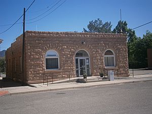
Minersville Town Hall
|
|

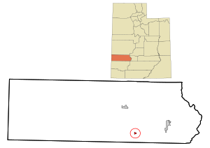
Location in Beaver County and the State of Utah
|
|

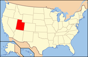
Location of Utah in the United States
|
|
| Country | United States |
| State | Utah |
| County | Beaver |
| Area | |
| • Total | 2.17 sq mi (5.63 km2) |
| • Land | 2.17 sq mi (5.63 km2) |
| • Water | 0.00 sq mi (0.00 km2) |
| Elevation | 5,164 ft (1,574 m) |
| Population
(2020)
|
|
| • Total | 807 |
| • Density | 371.9/sq mi (143.34/km2) |
| Time zone | UTC-7 (Mountain (MST)) |
| • Summer (DST) | UTC-6 (MDT) |
| ZIP code |
84752
|
| Area code | 435 |
| FIPS code | 49-50590 |
| GNIS feature ID | 2413004 |
Minersville is a small town in southeastern Beaver County, Utah, United States. In 2020, about 807 people lived there. This number was a bit lower than in 2010, when 907 people lived in Minersville.
Contents
History of Minersville
Minersville was founded in 1859. Brigham Young, a leader of the early settlers in Utah, asked for the town to be built. The main reason was to operate a lead mine.
Just one year before, in 1858, Jesse N. Smith and three other people had discovered lead in the area. This discovery led to the creation of Minersville.
The town's population changed over the years. In 1870, 446 people lived there. By 1900, the number was 525, and in 1930, it grew to 815 residents.
Where is Minersville?
Minersville is located in the southern part of Beaver County. It sits in the foothills of mountains. To the northwest are the Black Mountains. To the southwest are the Mineral Mountains. The town is also on the edge of the Escalante Desert.
Two main roads pass near Minersville. Utah State Route 21 goes through the northern part of town. It leads about 13 kilometers (8 miles) north to Milford. It also goes about 27 kilometers (17 miles) east to Beaver.
Utah State Route 130 goes south from Minersville. It leads about 64 kilometers (40 miles) to Cedar City.
The town covers a total area of about 5.63 square kilometers (2.17 square miles). All of this area is land.
Minersville's Climate
The weather in Minersville is generally mild. There are not big differences between the highest and lowest temperatures. The area also gets enough rain throughout the year. According to climate experts, Minersville has a type of climate called "marine west coast climate."
Minersville's Population
The population of Minersville has changed over time. Here's a look at how many people have lived there during different years:
| Historical population | |||
|---|---|---|---|
| Census | Pop. | %± | |
| 1870 | 446 | — | |
| 1880 | 487 | 9.2% | |
| 1890 | 463 | −4.9% | |
| 1900 | 437 | −5.6% | |
| 1910 | 591 | 35.2% | |
| 1920 | 675 | 14.2% | |
| 1930 | 537 | −20.4% | |
| 1940 | 570 | 6.1% | |
| 1950 | 593 | 4.0% | |
| 1960 | 580 | −2.2% | |
| 1970 | 448 | −22.8% | |
| 1980 | 552 | 23.2% | |
| 1990 | 608 | 10.1% | |
| 2000 | 817 | 34.4% | |
| 2010 | 907 | 11.0% | |
| 2020 | 807 | −11.0% | |
| U.S. Decennial Census | |||
In the year 2000, there were 817 people living in Minersville. These people lived in 256 households. A household is a group of people living together. Most of these households (204) were families.
Many households had children under 18 living with them, about 49.2%. Most households (73%) were married couples. About 18% of households were single individuals. Also, 11.7% of households had someone aged 65 or older living alone.
The average household in Minersville had about 3.19 people. The average family had about 3.68 people.
The age of people in Minersville varied. About 39% of the population was under 18 years old. About 12.7% were 65 years or older. The average age in the town was 26 years old.
See also
 In Spanish: Minersville (Utah) para niños
 | John T. Biggers |
 | Thomas Blackshear |
 | Mark Bradford |
 | Beverly Buchanan |

