
Milford, Utah facts for kids
Quick facts for kids
Milford, Utah
|
|
|---|---|

Milford train station, October 2017
|
|

Location in Beaver County and the state of Utah
|
|

Location of Utah in the United States
|
|
| Country | United States |
| State | Utah |
| County | Beaver |
| Founded | 1880 |
| Incorporated | 1903 |
| Founded by | Arvin Stoddard |
| Area | |
| • Total | 2.14 sq mi (5.54 km2) |
| • Land | 2.14 sq mi (5.54 km2) |
| • Water | 0.00 sq mi (0.00 km2) |
| Elevation | 4,961 ft (1,512 m) |
| Population
(2020)
|
|
| • Total | 1,431 |
| • Density | 668.7/sq mi (258.3/km2) |
| Time zone | UTC-7 (Mountain (MST)) |
| • Summer (DST) | UTC-6 (MDT) |
| ZIP code |
84751
|
| Area code(s) | 435 |
| FIPS code | 49-50040 |
| GNIS feature ID | 2411106 |
Milford is a small city in Beaver County, Utah, in the United States. In 2020, about 1,431 people lived there. Milford is known for its history with the railroad and its location in a desert area.
Contents
Milford's Past

People started ranching in the Milford area in the 1870s. But the city of Milford really began in 1880. This was when the San Pedro, Los Angeles and Salt Lake Railroad built a train station there.
Arvin Stoddard then surveyed the land and planned out the town. The name Milford comes from two words: mill and ford. A mill is a building that grinds grain, and a ford is a shallow place to cross a river.
During the Great Depression, a group called the Civilian Conservation Corps (CCC) helped build a road. These workers built a road from Milford to Beaver. This helped connect the two towns better.
Milford Flat Wildfire
A huge wildfire started near Milford on July 6, 2007. It was caused by lightning. This fire quickly grew very large.
By July 8, it was the biggest fire in Utah's history. It burned over 283,000 acres (about 1,145 square kilometers) of land.
Milford's Population
| Historical population | |||
|---|---|---|---|
| Census | Pop. | %± | |
| 1890 | 576 | — | |
| 1900 | 176 | −69.4% | |
| 1910 | 1,014 | 476.1% | |
| 1920 | 1,308 | 29.0% | |
| 1930 | 1,517 | 16.0% | |
| 1940 | 1,393 | −8.2% | |
| 1950 | 1,673 | 20.1% | |
| 1960 | 1,471 | −12.1% | |
| 1970 | 1,304 | −11.4% | |
| 1980 | 1,293 | −0.8% | |
| 1990 | 1,107 | −14.4% | |
| 2000 | 1,451 | 31.1% | |
| 2010 | 1,409 | −2.9% | |
| 2020 | 1,431 | 1.6% | |
| U.S. Decennial Census | |||
In 2000, Milford had 1,451 people living there. There were 484 households, which are groups of people living in one home. Most of these households were families.
Many homes had children under 18 living with them. The average household had almost three people. The average family had more than three people.
The median age in Milford was 28 years old. This means half the people were younger than 28, and half were older.
Milford's Location and Surroundings

Milford is in the eastern part of Beaver County. It sits in a flat area called the Escalante Desert. This desert is between the Mineral Mountains to the east and the Star Range to the west.
State Route 21 goes through Milford. This road leads south to Minersville. It also goes northwest towards the Nevada border. State Route 257 goes north from Milford to Delta.
The city of Milford covers about 8.0 square kilometers (3.1 square miles) of land. There is no water area within the city limits.
Milford's Weather
Milford has a semi-arid climate. This means it is generally dry, but not a true desert. It gets some rain and snow, but not a lot.
| Climate data for Milford, Utah (Milford Sound Airport), 1991–2020 normals, extremes 1928–2005 | |||||||||||||
|---|---|---|---|---|---|---|---|---|---|---|---|---|---|
| Month | Jan | Feb | Mar | Apr | May | Jun | Jul | Aug | Sep | Oct | Nov | Dec | Year |
| Record high °F (°C) | 69 (21) |
75 (24) |
88 (31) |
87 (31) |
97 (36) |
105 (41) |
107 (42) |
103 (39) |
102 (39) |
90 (32) |
78 (26) |
66 (19) |
107 (42) |
| Mean maximum °F (°C) | 53.4 (11.9) |
61.2 (16.2) |
71.3 (21.8) |
79.3 (26.3) |
87.8 (31.0) |
96.7 (35.9) |
100.5 (38.1) |
98.4 (36.9) |
92.6 (33.7) |
82.1 (27.8) |
69.0 (20.6) |
57.6 (14.2) |
100.7 (38.2) |
| Mean daily maximum °F (°C) | 40.8 (4.9) |
46.6 (8.1) |
57.5 (14.2) |
64.5 (18.1) |
75.5 (24.2) |
87.9 (31.1) |
95.0 (35.0) |
92.8 (33.8) |
82.9 (28.3) |
68.1 (20.1) |
53.2 (11.8) |
40.9 (4.9) |
67.1 (19.5) |
| Daily mean °F (°C) | 29.5 (−1.4) |
34.3 (1.3) |
42.9 (6.1) |
48.9 (9.4) |
58.5 (14.7) |
69.1 (20.6) |
77.0 (25.0) |
75.3 (24.1) |
65.2 (18.4) |
51.4 (10.8) |
38.8 (3.8) |
28.9 (−1.7) |
51.7 (10.9) |
| Mean daily minimum °F (°C) | 18.1 (−7.7) |
22.0 (−5.6) |
28.3 (−2.1) |
33.4 (0.8) |
41.5 (5.3) |
50.2 (10.1) |
59.1 (15.1) |
57.9 (14.4) |
47.4 (8.6) |
34.7 (1.5) |
24.4 (−4.2) |
16.8 (−8.4) |
36.2 (2.3) |
| Mean minimum °F (°C) | −8.9 (−22.7) |
−0.9 (−18.3) |
9.2 (−12.7) |
18.6 (−7.4) |
26.2 (−3.2) |
34.7 (1.5) |
44.8 (7.1) |
43.0 (6.1) |
29.8 (−1.2) |
19.1 (−7.2) |
4.4 (−15.3) |
−5.5 (−20.8) |
−13.7 (−25.4) |
| Record low °F (°C) | −34 (−37) |
−29 (−34) |
−14 (−26) |
9 (−13) |
17 (−8) |
24 (−4) |
34 (1) |
30 (−1) |
23 (−5) |
−20 (−29) |
−13 (−25) |
−35 (−37) |
−35 (−37) |
| Average precipitation inches (mm) | 0.60 (15) |
0.65 (17) |
1.01 (26) |
0.76 (19) |
0.90 (23) |
0.45 (11) |
0.70 (18) |
0.56 (14) |
0.72 (18) |
1.09 (28) |
0.53 (13) |
0.70 (18) |
8.67 (220) |
| Average snowfall inches (cm) | 6.8 (17) |
6.6 (17) |
8.9 (23) |
3.5 (8.9) |
0.6 (1.5) |
0.0 (0.0) |
0.0 (0.0) |
0.0 (0.0) |
0.1 (0.25) |
1.3 (3.3) |
4.2 (11) |
8.4 (21) |
40.4 (102.95) |
| Average precipitation days (≥ 0.01 in) | 5.9 | 6.4 | 6.6 | 6.8 | 5.8 | 2.6 | 6.8 | 6.2 | 4.7 | 5.1 | 4.9 | 7.1 | 68.9 |
| Average snowy days (≥ 0.1 in) | 3.1 | 2.4 | 3.2 | 1.3 | 0.5 | 0.0 | 0.0 | 0.0 | 0.1 | 0.8 | 1.4 | 3.0 | 15.8 |
| Source 1: WRCC (mean maxima and minima 1928–2005) | |||||||||||||
| Source 2: NOAA(September record) | |||||||||||||
Fun Things to Do in Milford
Milford has several places for recreation and fun. There is a swimming pool that is open during certain seasons. You can also find a five-hole golf course.
The city has lighted fields for playing ball games. There is also a pavilion and a rodeo arena. The American Discovery Trail, a long trail for hiking and biking, also passes through Milford.
Historic Photo Gallery
-
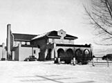
Train depot in Milford, Utah, during the winter of 1936-1937
-
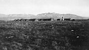
Civilian Conservation Corp camp at Milford, Utah
-
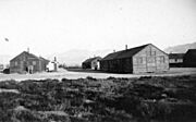
Barracks at CCC camp 2530
-
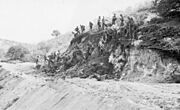
CCC workers with picks and shovels building road in Utah between Milford and Beaver


See also
 In Spanish: Milford (Utah) para niños
