Tushar Mountains facts for kids
Quick facts for kids Tushar Mountains |
|
|---|---|

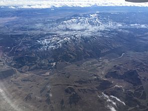
View looking southeast from an airplane
|
|
| Highest point | |
| Peak | Delano Peak |
| Elevation | 12,174 ft (3,711 m) |
| Geography | |
| Country | United States |
The Tushar Mountains are a tall mountain range in Utah. They are the third highest range in the state, after the Uinta Mountains and the La Sal Range. You can find them in the Fishlake National Forest.
The highest point in the Tushars is Delano Peak. It stands at 12,174 feet (3,711 meters) tall. Delano Peak is the highest spot in both Beaver and Piute counties. It is named after Columbus Delano, who was a government official in the 1800s. Even though the Tushars are in a dry area, they get a lot of snow each year. This is because of their high elevation.
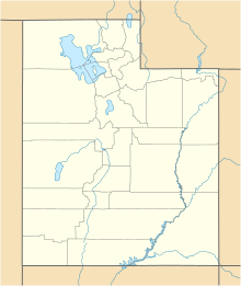
The main part of the Tushar Mountains is in Beaver, Piute, and Sevier counties. Parts of the range also reach into Millard, Garfield, and Iron counties.
You can easily reach the Tushar Mountains. I-15 is to the west, I-70 to the north, and US–89 to the east. U–20 is to the south. Another road, U–153, goes right through the southern part of the mountains. It connects the towns of Beaver and Junction.
Contents
Tallest Peaks in the Tushar Mountains
The Tushar Mountains have many impressive peaks. Here are some of the most prominent ones:
- Mount Belknap 12,137 feet (3,700 m)
- Mount Baldy 12,090 feet (3,685 m)
- Mount Brigham 11,709 feet (3,569 m)
- Edna Peak 11,654 feet (3,552 m)
- Copper Belt Peak 11,358 feet (3,462 m)
- Circleville Mountain 11,338 feet (3,456 m)
How the Tushar Mountains Were Formed
The Tushar Mountains were created by volcanoes a long time ago, between 22 and 32 million years ago. There was even a huge volcanic explosion that blew off the top of a massive peak! This area is special because it sits where the Great Basin meets the Colorado Plateau. This means it has features from both regions.
The geology here is very interesting. You'll find rocks formed from lava flows and volcanic ash from ancient volcanoes. There are also calderas (large volcanic craters), volcanic domes, and cinder cones. Different types of rocks like rhyolite and basalt are present. You can even find valuable metals like gold and molybdenum. The area also has geothermal activity, which means hot water from underground.
The Tushars have at least seven high mountain canyons that were shaped by glaciers during the last ice age. These include Cottonwood Canyon, Bullion Basin, and Beaver Basin.
Rivers and Water in the Tushars
The Tushar Mountains are home to many streams and creeks. These waterways get their water from the snow that melts each year. All the water from the Tushars eventually flows into Sevier Lake in western Utah. This lake is part of the Great Basin, which means no water from the Tushars reaches the ocean.
Beaver River
The Beaver River starts in the Tushar Mountains, east of Beaver. It flows west past Beaver and Milford. In the past, this river was known for having many beaver colonies.
Sevier River
The Sevier River is the longest river that stays entirely within Utah, stretching 383 miles (616 km). It drains many mountain valleys used for farming. A lot of the water from the Upper Sevier River is used for irrigation. Because of this, Sevier Lake is mostly dry now. Sevier Lake is what's left of a much larger ancient lake called Lake Bonneville.
Important Creeks and Streams
Some of the well-known creeks and streams in the Tushars include Clear Creek, Pine Creek, and Cottonwood Creek. All these smaller streams eventually flow into the Sevier River.
Plants and Animals of the Tushars
The Tushar Mountain range is part of a temperate coniferous forest. This means it has many evergreen trees. Common trees include ponderosa pine, Douglas-fir, subalpine fir, and Engelmann spruce. You'll also find trembling aspen and Gambel oak. The Tushars have some very old pine trees, some of the oldest in Utah!
Plant Life and Communities
Because the elevation changes so much, the Tushars have many different types of plants. You can find plants that grow in high alpine areas and mountain meadows. There are dense forests of aspen and Engelmann spruce. Other plants include pine trees, Douglas fir, mountain brush, and sagebrush. You might even spot special plants found only in the Tushars, like the Tushar paintbrush. Recent fires, both natural and controlled, have helped new plants like Aspen grow back.
Fun Activities in the Tushar Mountains
The Tushar Mountains are a great place for outdoor adventures!
Skiing and Snowboarding
Eagle Point ski resort is located on the western slopes of the Tushars. You can get there from Beaver. It's a popular spot for skiing and snowboarding in winter.
Hiking and Biking
There are hundreds of miles of trails for mountain biking and hiking. These trails wind through the canyons and valleys, letting you explore the beautiful backcountry.
ATV Riding
The Tushars are also part of the Paiute ATV Trail system. This is one of the longest ATV trails in the United States, offering lots of opportunities for off-road fun.
Unique Features of the Tushar Mountains
The Tushar Mountains offer a strong sense of natural beauty and quiet. There are endless chances for outdoor fun away from crowds. The area has some truly special features.
Big Rock Candy Mountain Altered Zone
One unique spot is the Big Rock Candy Mountain Altered Zone. This area is famous for showing how hot water from underground can change rocks. The rocks here are brightly colored because of this process. It's a very distinctive place in the Colorado Plateau.
Skinner Canyon Ignimbrites
Along the I-70 road in Clear Creek Canyon, you can see amazing rock formations called the Skinner Canyon Ignimbrites. These are strong, jointed volcanic glass outcrops. The way the rocks are shaped here is almost unique in the Colorado Plateau.
The Tushar Mountains are easy to get to from several directions. You can come from U.S. 89 through Marysvale, Junction, and Circleville. You can also use I-15 through Beaver, Utah, or I-70 in Clear Creek Canyon.
 | Chris Smalls |
 | Fred Hampton |
 | Ralph Abernathy |


