Salina, Utah facts for kids
Quick facts for kids
Salina, Utah
|
|
|---|---|

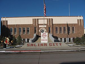
Salina City Hall
|
|
| Nickname(s):
North Sevier
|
|

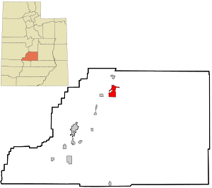
Location in Sevier County and the state of Utah.
|
|
| Country | United States |
| State | Utah |
| County | Sevier |
| Settled | 1864 |
| Named for | Spanish for 'salt mine' |
| Area | |
| • Total | 5.83 sq mi (15.10 km2) |
| • Land | 5.83 sq mi (15.10 km2) |
| • Water | 0.00 sq mi (0.00 km2) |
| Elevation | 5,161 ft (1,573 m) |
| Population
(2020)
|
|
| • Total | 2,660 |
| • Estimate
(2019)
|
2,612 |
| • Density | 447.95/sq mi (172.97/km2) |
| Time zone | UTC-7 (Mountain (MST)) |
| • Summer (DST) | UTC-6 (MDT) |
| ZIP code |
84654
|
| Area code(s) | 435 |
| FIPS code | 49-65880 |
| GNIS feature ID | 1445269 |
Salina (pronounced sə-LY-nə) is a city in Sevier County, Utah, United States. In 2020, about 2,660 people lived there. The name "Salina" comes from a Spanish word meaning 'salt mine'. This is because early settlers found a lot of salt nearby.
Contents
History of Salina
Early Settlement and Challenges
The first people to settle permanently in the Salina area arrived in 1864. There were about 30 families. They were sent there by leaders of the Church of Jesus Christ of Latter-day Saints. They quickly found many salt deposits, which is why they named the area "Salina."
However, in 1866, the settlers faced problems with Native Americans. The area was a traditional hunting ground for them. This conflict, known as the Black Hawk War (Utah), forced the settlers to leave Salina and move to the Manti area for safety.
Returning and Building the Town
The settlers came back to Salina in 1871. They formed a local defense group called a militia. They also built a fort to protect themselves. New buildings for a school and a church were also constructed. Around this time, they found large amounts of coal in the canyon east of the settlement.
Water was very important for the growing community. A creek north of the settlement was used to provide water for farming and homes. It also powered businesses like sawmills and grist mills. These mills ground grain into flour. Water was also used for salt refineries and to make electricity. In 1874, they started using water from the Sevier River. By 1908, the land west of the settlement was fully farmed.
Growth and Modernization
In June 1891, Salina was connected to the state's railroad system. This was a big step for the community. That same year, the central part of Salina officially became a town. It quickly became a key shipping point. Goods from nearby settlements were sent from Salina to other parts of Utah. In 1913, the town grew even more and was re-established as a city.
World War II Incident
During World War II, Salina had a special camp. It held about 250 German prisoners of war. Most of these prisoners were from the Afrikakorps, a famous German army group. On July 8, 1945, an incident occurred at the camp. A guard fired shots towards the tents where the prisoners were sleeping. Six prisoners died, and 22 others were injured. Three of the injured later passed away. This event is known as the Salina Massacre.
Geography and Climate
Salina covers an area of about 6.2 square miles (15.9 square kilometers). All of this area is land.
Climate
Salina gets about 7.82 inches (20 centimeters) of rain each year. Because it doesn't get much rain, the area is considered a desert.
Population Changes
| Historical population | |||
|---|---|---|---|
| Census | Pop. | %± | |
| 1880 | 438 | — | |
| 1890 | 628 | 43.4% | |
| 1900 | 847 | 34.9% | |
| 1910 | 1,082 | 27.7% | |
| 1920 | 1,451 | 34.1% | |
| 1930 | 1,383 | −4.7% | |
| 1940 | 1,616 | 16.8% | |
| 1950 | 1,789 | 10.7% | |
| 1960 | 1,618 | −9.6% | |
| 1970 | 1,494 | −7.7% | |
| 1980 | 1,992 | 33.3% | |
| 1990 | 1,943 | −2.5% | |
| 2000 | 2,393 | 23.2% | |
| 2010 | 2,489 | 4.0% | |
| 2019 (est.) | 2,612 | 4.9% | |
| U.S. Decennial Census | |||
In 2000, Salina had 2,393 people living there. The population density was about 389 people per square mile. The city had 808 households. Most households were families.
The population included many young people. About 35% of the people were under 18 years old. The average age in Salina was 28 years.
Economy and Jobs
Early Economy
When Salina was first settled, people mainly focused on farming. They grew food to feed themselves. But soon, other businesses started. By the 1870s, Salina had a telegraph line for sending messages. It also had regular mail service and coal mines.
Growth with the Railroad
In June 1891, the railway came to Salina. This made the town a major hub for transportation. It connected the local settlements to the rest of Utah. This led to a big increase in businesses and population. By the late 1800s, Salina had its own newspaper. It also had a city hall, a library, and an eight-room elementary school. There were also many places for entertainment like saloons and dancehalls.
Modern Developments
During the Great Depression, a special camp was set up east of Salina. It was part of the Civilian Conservation Corps. People from this camp worked on building dams, roads, and recreation areas. The government also provided money to build a new city hall and library. They also improved the city's water and wastewater systems.
In the 1940s, the Salina Livestock Auction and the Salina Turkey Plant were started. The turkey plant is now part of Norbest. Both of these businesses are still open today. The Convulsion Canyon mine also grew. It became part of Arch Coal, Inc., and is now known as the SUFCO Mine. This mine is currently owned by Bowie Resource Partners.
Salina is now working to develop a large commercial area south of town. It is located where I-70 and US 89 meet. The city and a grant from the US Economic Development Administration are funding this project. It will have 50 business lots of different sizes.
Education
Salina has one elementary school, one middle school, and one high school. These schools are part of the Sevier School District. The closest college is a branch of Snow College. It is located in Richfield, which is about 20 miles (32 kilometers) south of Salina.
Fun and Recreation
The Salina city library is located at 90 West Main Street.
Salina is also at the start of a large ATV trail. This trail is called the Paiute Trail. It covers the southern part of Utah. It's a great place for riding ATVs.
Getting Around
The closest airport is the Salina-Gunnison Airport. It is about 8 miles (13 kilometers) north of Salina. Its longest paved runway is 3,815 feet (1,163 meters). The Richfield Airport is 22 miles (35 kilometers) south of Salina. It has a longer paved runway of 6,645 feet (2,025 meters).
Major roads meet in Salina. These include Interstate 70, U.S. Route 50, and U.S. Route 89. These roads connect Salina to other areas. The western end of Utah State Route 24 is also in Salina.
Famous People from Salina
- Earl W. Bascom – a pioneer in rodeo, an artist, and an inventor. He is known as the "Father of Modern Rodeo."
- Dell Loy Hansen – a businessman and owner of sports teams.
 | Selma Burke |
 | Pauline Powell Burns |
 | Frederick J. Brown |
 | Robert Blackburn |

