
The Dalles Dam facts for kids
Quick facts for kids The Dalles Dam |
|
|---|---|

From the Washington side
|
|
| Official name | The Dalles Lock and Dam |
| Location | Klickitat County, Washington / Wasco County, Oregon, USA |
| Coordinates | 45°36′44″N 121°08′04″W / 45.61222°N 121.13444°W |
| Construction began | 1952 |
| Opening date | 1957 |
| Operator(s) | U.S. Army Corps of Engineers (Operator) Bonneville Power Administration (Marketer) |
| Dam and spillways | |
| Type of dam | Concrete gravity, run-of-the-river |
| Height | 200 feet (61 m) |
| Length | 8,835 feet (2,693 m) |
| Width (base) | 239 feet (73 m) (Spillway) |
| Spillway type | Service, gate-controlled |
| Spillway capacity | 2,290,000 cu ft/s (65,000 m3/s) |
| Reservoir | |
| Creates | Lake Celilo |
| Total capacity | 330,000 acre⋅ft (0.41 km3) |
| Power station | |
| Turbines | 22 |
| Installed capacity | 1,878.3 MW Max.: 2,160 MW |
| Annual generation | 6,180 GWh |
The The Dalles Dam is a huge concrete wall that stretches across the Columbia River. It is located about two miles (3 km) east of the city of The Dalles, Oregon, in the United States. This dam connects Wasco County, Oregon with Klickitat County, Washington. It sits 192 miles (309 km) upstream from where the Columbia River meets the ocean near Astoria, Oregon. The closest towns on the Washington side are Dallesport and Wishram.
The Dalles Dam is a "run-of-the-river" dam. This means it uses the natural flow of the river to create electricity, rather than storing a huge amount of water.
Contents
Building The Dalles Dam
The U.S. Army Corps of Engineers started building The Dalles Dam in 1952. They finished the project five years later, in 1957.
Impact on Native American Culture
When the dam was built, the water behind it rose and covered an important area called Celilo Falls. This place was very special to Native American tribes in the region. It was a center for trade and culture, and people had lived there for thousands of years.
On March 10, 1957, many people watched as the rising water slowly covered the falls. It also submerged fishing spots and the village of Celilo. Ancient rock carvings, called petroglyphs, were also in the area that was going to be underwater. About 40 of these petroglyph panels were carefully removed before the water rose. They were later moved to Columbia Hills State Park in the 2000s.
What the Dam Does
The large body of water created by the dam is called Lake Celilo. This lake stretches for 24 miles (39 km) up the river, all the way to the John Day Dam.
The U.S. Army Corps of Engineers (USACE) is in charge of running The Dalles Dam. The electricity it makes is sold by the Bonneville Power Administration (BPA). The Dalles Dam is one of many dams that are part of a big system on the Columbia and Snake Rivers. These dams help control the rivers and produce power.
Visiting The Dalles Dam
You can visit The Dalles Dam Visitor Center. It is located in Seufert Park on the Oregon side of the river. The center was built in 1981. There used to be a tour train that took visitors around, but it closed in 2001. This was partly due to security concerns after the September 11 attacks. The Columbia Hills State Park is also nearby, offering more outdoor activities.
Dam Facts and Figures
The Dalles Dam is an impressive structure with many parts that work together.

- Height: The dam stands about 200 feet (61 meters) tall.
- Length: It stretches for 8,835 feet (2,693 meters) across the river.
- Navigation Lock: There is a special lock that allows boats to pass through the dam. It is 86 feet (26 meters) wide and 675 feet (206 meters) long.
- Powerhouse: This is where the electricity is made. The powerhouse is 2,089 feet (637 meters) long. It has 22 large machines called turbines. These turbines can produce a total of 1,878.3 megawatts of electricity. They can even reach an overload capacity of 2,160 megawatts.
- Spillway: The spillway is a part of the dam that lets extra water flow through safely. It has 23 gates and is 1,447 feet (441 meters) long. It can handle a huge amount of water, up to 2,290,000 cubic feet per second.
Images for kids
-
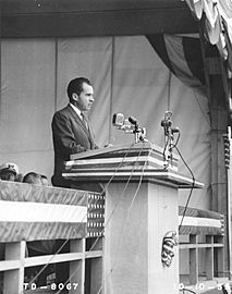
Vice-President Richard Nixon speaking at The Dalles Dam dedication in 1959.
-
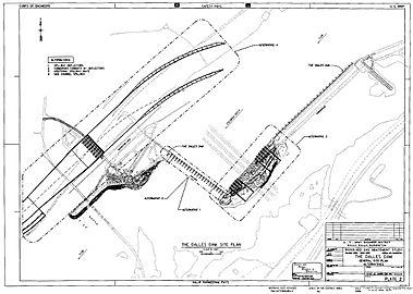
The Dalles Dam site plan.
-
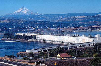
Looking west, fish ladder in the foreground, power generation center. Mount Hood rises in the background.
-
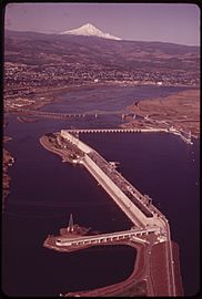
The Dalles Dam in
June 1973.


