Wishram, Washington facts for kids
Quick facts for kids
Wishram, Washington
|
|
|---|---|
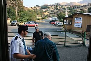
Passengers deboarding the Empire Builder at Wishram station
|
|
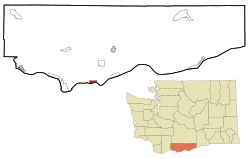
Location of Wishram in Klickitat County, Washington
|
|
| Country | United States |
| State | Washington |
| County | Klickitat |
| Area | |
| • Total | 1.3 sq mi (3.3 km2) |
| Elevation | 177 ft (54 m) |
| Population
(2020)
|
|
| • Total | 366 |
| • Density | 287/sq mi (110.9/km2) |
| Time zone | UTC-8 (Pacific (PST)) |
| • Summer (DST) | UTC-7 (PDT) |
| ZIP code |
98673
|
| Area code(s) | 509 |
| FIPS code | 53-79485 |
| GNIS feature ID | 1528268 |
Wishram is a small community in Klickitat County, Washington, USA. In 2020, about 366 people lived there. It's close to the famous Celilo Falls, a historic fishing spot on the Columbia River.
This place was first called "Fallbridge." Its name was changed to "Wishram" to honor the Wishram tribe. In 1957, The Dalles Dam was finished about 9 miles downstream. This dam created Lake Celilo, which covered the original fishing village near Wishram.
Contents
Where is Wishram Located?
Wishram is located at 45°39′40″N 120°57′32″W / 45.66111°N 120.95889°W.
The United States Census Bureau says that Wishram covers about 1.3 square miles (3.3 square kilometers) of land. There is no water area within the community itself.
How Wishram's Landscape Formed
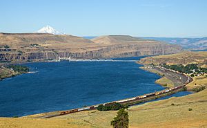
Wishram's location is special because of two big natural features. One is Celilo Falls on the Columbia River. The other is how easy it is to get to the Central Oregon Plateau through the Deschutes River valley, which is just across the falls.
The falls gave early people a steady supply of food. Later, they made it easy to build a railroad bridge across the Columbia River. The Deschutes valley also provided a path for trains to go south, all the way to California.
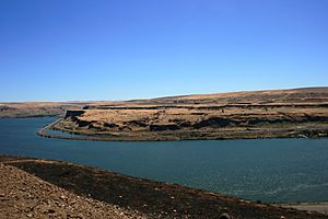
Wishram is near the upper part of the Columbia River Gorge. This gorge started forming millions of years ago. Thick layers of basalt rock were laid down. The Cascade Mountains also began to form, slowly moving the Columbia River to where it is today.
The river slowly wore away the land over a long time. But the biggest changes happened at the end of the last Ice Age. Huge floods, called the Missoula Floods, carved out the steep, dramatic walls you see around Wishram today. During these floods, the water rose 700 feet higher than it is now. This powerful water violently eroded the land, showing off the layers of volcanic rock.
A Look at Wishram's Past
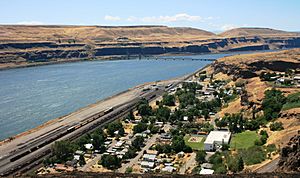
The area where Wishram is located has been lived in for a very long time, about 15,000 years! This is because it was just above the great Celilo Falls on the Columbia River. Native peoples gathered here to fish and trade goods. They built wooden platforms over the water. From these platforms, they caught salmon using dipnets and long spears as the fish swam and jumped over the falls.
Celilo Falls was an important trading center. It was located where different Native American language groups, like the Chinookan and Sahaptian speakers, met. Early explorers and historians wrote about this busy trading spot.
In 1892, the U.S. government built a set of locks on the southern shore, across from Wishram. These locks helped boats get around Celilo Falls. They cost $5,000,000 to build. However, they were not used much because more and more goods started moving by train.
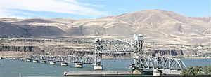
In 1912, the community was known as Fallbridge. It was named after the Oregon Trunk Rail Bridge. This bridge was built on the basalt rock of Celilo Falls. It was part of the Spokane, Portland and Seattle Railway, which extended south.
Famous Visitors: Lewis and Clark
The famous explorers Lewis and Clark wrote about the Wishram area in their journals.
When they returned on April 16, 1806, they noted that the village had moved. It was about 300 yards below where it had been the previous fall. They observed that the village often moved to the best fishing spots.
Other Early Visitors
The American author, Washington Irving, also wrote about the Native Americans living at Wishram. He mentioned them in his book Astoria Or, Anecdotes Of An Enterprise Beyond The Rocky Mountains, published in 1836.
Many other important people visited Wishram in the early 19th century. These included Thomas J. Farnham, Hudson's Bay Company Governor Sir George Simpson, Alexander Ross, Father Pierre Desmet, and Joseph Drayton from the Wilkes Expedition. Ross reported that during salmon season, the summer camps at Wishram could have as many as 3,000 Native Americans. Father Desmet described it as a joyful time of celebration, games, and feasting.
There have been villages at the Wishram location for thousands of years. In the 1950s, archaeologists found old village sites with layers of waste from centuries of living. They also found petroglyphs (rock carvings) and other signs of many people living there. Most of these busy areas were close to the river for easy fishing. This lower area was flooded in 1957 when water backed up behind The Dalles Dam.
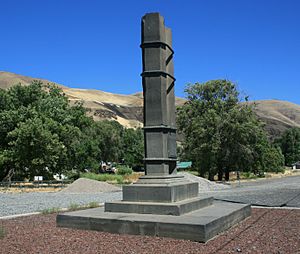
In 1926, a memorial for pioneers was put up in Wishram/Fallbridge. It is still there today, about 100 feet east of the train station. It has two basalt columns held together with iron straps, sitting on a base. A bronze plaque lists pioneers who visited Wishram, starting with Meriwether Lewis and ending with John C. Fremont. This monument originally marked the start of a path to Celilo Falls. That path is now covered by the water from The Dalles Dam.
Wishram as a Rail Center
The Spokane, Portland and Seattle Railway (SP&S) was started in 1905 by James J. Hill. He wanted to connect his two big railroads, the Northern Pacific and Great Northern, to Portland, Oregon. This would help him get a share of the lumber business in Oregon.
Construction began in 1906. The SP&S built the first bridge of any kind across the lower Columbia River. This bridge is now called the BNSF Railway Bridge 9.6 in Vancouver.
Within a year, the railway line reached Pasco, Washington, connecting with Northern Pacific lines. The first part of the line, from Pasco west through Wishram, opened on December 15, 1907.
The town of Wishram (then Fallbridge) was a great spot for a bridge across the Columbia River. It was possible to build a bridge with piers (supports) resting on basalt rock that was usually above the water. This meant the bridge could handle the raging rapids during high water. This bridge over Celilo Falls became known as the Oregon Trunk Rail Bridge. The bridge's location also allowed trains to travel along the Deschutes River canyon. This opened up access to eastern Oregon's high desert and the eastern Cascade Mountains.
Because of this, the SP&S railway was extended south from Wishram toward Bend, Oregon. James J. Hill officially opened this route in 1912. Fallbridge became an important center for trains. It had a passenger station, a roundhouse for fixing trains, and a freight yard. In 1920, a large coaling station was built there for the Spokane, Portland & Seattle Railroad.
The town's name was officially changed to Wishram in 1926. However, the name Fallbridge still appeared in some documents. For example, in 1931, railway schedules used "Wishram (Fallbridge)" for the stop.
In 1931, the SP&S line to Bend was connected to Klamath Falls, Oregon and then to Bieber, California. This created a shortcut to connect with the Western Pacific Railroad in Northern California.
People of Wishram
| Historical population | |||
|---|---|---|---|
| Census | Pop. | %± | |
| 2000 | 213 | — | |
| 2010 | 342 | 60.6% | |
| 2020 | 366 | 7.0% | |
| US Decennial Census 2020 Census |
|||
In 2010, there were 342 people living in Wishram. Most residents (88.9%) were White. About 6.1% were Native American, and 1.2% were African American. About 8.5% of the population was Hispanic or Latino.
In 2000, there were 213 people. The average household had about 2.13 people. The average family had about 2.74 people.
The population was spread out by age. About 25% were under 18 years old. About 19.4% were 65 years or older. The average age was 41 years.
Getting Around Wishram
- Wishram (Amtrak station)
Wishram is a small train stop with a large facility for maintaining trains. It handles train traffic coming north from Oregon and California, as well as trains going west. The section of railroad that runs from Vancouver to Pasco still uses the town's original name, Fallbridge.
See also
 In Spanish: Wishram (Washington) para niños
 | DeHart Hubbard |
 | Wilma Rudolph |
 | Jesse Owens |
 | Jackie Joyner-Kersee |
 | Major Taylor |


