Boyd, Oregon facts for kids
Quick facts for kids
Boyd, Oregon
|
|
|---|---|

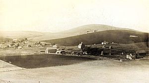
1908 photo of Boyd courtesy Gilhousen Family Association.
|
|
 |
|
| Country | United States |
| State | Oregon |
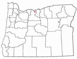
| County | Wasco |
| Established | 1861 |
| Disincorporated | 1955 |
| Area | |
| • Total | 0 sq mi (0 km2) |
| Elevation | 1,227 ft (374 m) |
| Population
(2006)
|
|
| • Total | 0 |
| Time zone | UTC-8 (Pacific) |
| • Summer (DST) | UTC-7 (Pacific) |
| ZIP code |
97021
|
| Area codes | 458 and 541 |
Boyd was once a small town in Wasco County, Oregon, United States. It officially stopped being a town in 1955. Today, you'll only find a few old, empty houses, worn-out farm buildings, and a tall, wooden grain elevator that's no longer used. These buildings are surrounded by large wheat fields.
The land where Boyd used to be was recently bought and turned into farmland. You can see the site from U.S. Route 197, about 9.5 miles (15.3 km) southeast of The Dalles.
Contents
History of Boyd
Early Settlers and Gold Rush
People traveling west on the Barlow Road might have passed through or near Boyd as early as 1847. But the first real community started more than ten years later. This happened when gold was found near John Day in 1861. Even more gold was discovered in Canyon City, Oregon the next year.
A Busy Stagecoach Stop
The area that became Boyd was already a stagecoach stop. It had an inn called Eleven Mile House. This spot was near the banks of Fifteenmile Creek. The area became very busy during the gold rush. Every day, many miners, pack animals, and freight wagons traveled from The Dalles to Canyon City.
All this travel created a need for places to stay, blacksmiths, and stables for horses. So, a community grew around Eleven Mile House. It also served the growing number of farmers settling nearby.
Growth of the Community
In 1863, a schoolhouse was built east of Boyd on Fifteenmile Creek. This building was also used for church services. The community kept growing. A flour mill was built, which was later bought by T.P. Boyd and his four sons. The town was named after them. The U.S. Government opened a post office in the general store, using the name Boyd.
The community continued to get bigger. In 1895, a town plat (a map showing land divisions) was drawn. Several new businesses opened, and a Methodist church was started. This church shared a pastor with the church in Dufur, Oregon. The Boyd school became known as District #21.
Railroad and Decline
The Great Southern Railroad started running directly through Boyd in 1905. It carried passengers, goods, mail, and wheat. Boyd thrived during this time. However, things changed when The Dalles – California Highway was built in 1923. This highway, now U.S. Route 197, went around the town, not through it.
The years after 1923 were tough for Boyd. The Great Depression also hurt local businesses. Farmers were getting low prices for their wheat. Fewer travelers came through town, so businesses lost customers. It became easier for people to travel to nearby Dufur and The Dalles for shopping and services. Because of this, the post office in Boyd closed in 1952.
See also
 In Spanish: Boyd (Oregón) para niños
 | Calvin Brent |
 | Walter T. Bailey |
 | Martha Cassell Thompson |
 | Alberta Jeannette Cassell |


