
Rufus, Oregon facts for kids
Quick facts for kids
Rufus, Oregon
|
|
|---|---|

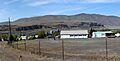
Rufus, with the fire department in foreground
|
|

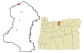
Location in Oregon
|
|
| Country | United States |
| State | Oregon |
| County | Sherman |
| Incorporated | 1965 |
| Area | |
| • Total | 1.34 sq mi (3.48 km2) |
| • Land | 1.18 sq mi (3.07 km2) |
| • Water | 0.16 sq mi (0.41 km2) |
| Elevation | 235 ft (71.6 m) |
| Population
(2020)
|
|
| • Total | 268 |
| • Density | 226.35/sq mi (87.38/km2) |
| Time zone | UTC-8 (Pacific) |
| • Summer (DST) | UTC-7 (Pacific) |
| ZIP code |
97050
|
| Area code(s) | 541 |
| FIPS code | 41-64200 |
| GNIS feature ID | 2411013 |

Rufus is a small city in Sherman County, Oregon, United States. In 2020, about 268 people lived there. The city was named after an early settler, Rufus Carrol Wallis.
Rufus is located right next to the Columbia River and the John Day Dam. It's in a high desert area. You can find many kinds of wildlife here, like porcupines, coyotes, deer, and various birds such as hummingbirds, ospreys, and kestrels.
The city has a few useful places for residents and visitors. These include a gas station, a post office, a tackle shop, a market, two restaurants, and two hotels. Rufus is also home to Giles French waterfront park. This park has a free boat launch for the Columbia River. It's a great spot for watching birds and even offers short-term free camping.
Rufus is also important for its history. An archaeological site, called 35SH119, is located here. For thousands of years, different Native American groups visited this site. They came to collect petrified wood and other materials. These materials were used to make stone tools. Even though petrified wood wasn't as good as obsidian for tools, the site was popular because it was easy to reach. This quarry site is on the west side of Rufus.
Contents
Geography of Rufus
Rufus is a small city with a total area of about 1.21 square miles (3.13 square kilometers). Most of this area is land, about 1.19 square miles (3.08 square kilometers). A small part, about 0.02 square miles (0.05 square kilometers), is water.
What is the Climate Like in Rufus?
Rufus has a type of weather called a warm-summer Mediterranean climate. This means the summers are warm and dry, but not extremely hot. The average monthly temperatures do not go above 71.6 degrees Fahrenheit (22 degrees Celsius).
Population and People in Rufus
| Historical population | |||
|---|---|---|---|
| Census | Pop. | %± | |
| 1970 | 317 | — | |
| 1980 | 352 | 11.0% | |
| 1990 | 295 | −16.2% | |
| 2000 | 264 | −10.5% | |
| 2010 | 249 | −5.7% | |
| 2020 | 268 | 7.6% | |
| U.S. Decennial Census | |||


Rufus Population in 2010


In 2010, the city of Rufus had 249 people living there. There were 115 households, and 65 of these were families. The city had about 209 people per square mile.
Most of the people living in Rufus in 2010 were White (89.2%). About 5.2% were Native American. Also, 13.3% of the population identified as Hispanic or Latino.
The average age of people in Rufus was about 51.1 years old. About 16.9% of residents were under 18. About 24.9% were 65 years old or older. Slightly more than half of the population (52.6%) was male, and 47.4% was female.
Images for kids
-
Rufus, with the fire department in foreground
-
Location in Oregon
-
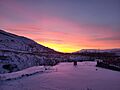
A sunset on a snowy evening in Rufus
-
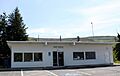
The post office in Rufus
-
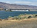
The John Day Dam is right next to Rufus on the Columbia River
-
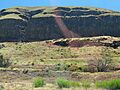
Basalt cliffs rise above Rufus, Oregon
-
Rufus has a free boat launch for the Columbia River
See also
 In Spanish: Rufus (Oregón) para niños
