Trout Creek (Deschutes River tributary) facts for kids
Quick facts for kids Trout Creek |
|
|---|---|

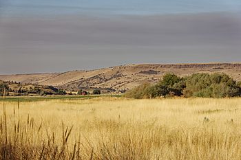
Trout Creek valley near the mouth of Antelope Creek
|
|

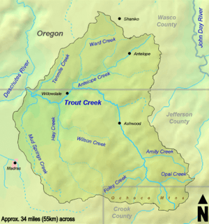
Trout Creek watershed
|
|
|
Location of the mouth of Trout Creek in Oregon
|
|
| Country | United States |
| State | Oregon |
| Counties | Crook, Jefferson, and Wasco |
| Physical characteristics | |
| Main source | Ochoco Mountains northeast of Prineville, Crook County, Oregon 5,593 ft (1,705 m) 44°30′42″N 120°33′20″W / 44.51167°N 120.55556°W |
| River mouth | Deschutes River at the Jefferson/Wasco county line, Oregon 1,283 ft (391 m) 44°49′17″N 121°05′19″W / 44.82139°N 121.08861°W |
| Length | 51 mi (82 km) |
| Basin features | |
| Basin size | 692 sq mi (1,790 km2) |
Trout Creek is a 51-mile (82 km) long river in Oregon, USA. It flows into the Deschutes River. The creek helps drain about 692 square miles (1,792 km2) of land. This area covers parts of Crook, Jefferson, and Wasco counties. Trout Creek starts in the Ochoco Mountains and flows north, then west, until it joins the Deschutes River.
Exploring Trout Creek's Path
Trout Creek begins high up in the western Ochoco Mountains. This area is northeast of Prineville. As it flows, it collects water from smaller streams. These include Auger Creek and Amity Creek.
The creek then turns northwest and later west. It flows near Ashwood, which is an old ghost town. Here, the creek runs along the border between Jefferson and Wasco counties. A stream called Antelope Creek joins Trout Creek from its right side.
Further downstream, Highway 97 crosses the creek near Willowdale. After this, Hay and Mud Springs creeks add their water from the left side. Finally, Trout Creek flows into the Deschutes River. This meeting point is about 87 miles (140 km) before the Deschutes River reaches the Columbia River.
Understanding the Trout Creek Watershed
The Trout Creek watershed is a large area of land that drains into the creek. It covers 692 square miles (1,792 km2) in central Oregon. The land in this watershed ranges from high mountains to lower areas. The highest points are about 5,940 feet (1,811 m) near where the creek starts. The lowest point is 1,283 feet (391 m) where it meets the Deschutes River.
The amount of rain and snow (precipitation) in the watershed changes. Lower areas get about 8 to 10 inches (203 to 254 mm) of rain each year. The mountains, however, can get up to 28 inches (711 mm). Most of the land, 88%, is privately owned. The rest is managed by government groups like the United States Forest Service.
Most of the land (86%) is rangeland, which is open land for grazing animals. About 12% is covered by forests. A small part, 2%, is used for farming. Less than 1% of the land is developed for towns or rural homes.
A Look at Trout Creek's Past
People have lived near Trout Creek for a very long time. The first humans arrived in the area about 10,000 years ago. Scientists found an old pit-house near Willowdale that is at least 5,000 years old.
The first European Americans came to the area in the 1820s. These were fur traders, including a group led by Peter Skene Ogden. Settlers began to arrive in the 1860s.
In the late 1800s, gold and silver were discovered in the area. This led to growth, and the Ashwood post office opened in 1898. Mines for silver and cinnabar (a mineral used to get mercury) began operating. Many homesteaders, or new settlers, came in the early 1910s. Cinnabar mining was busiest in the 1960s.
After big floods in 1964, the United States Army Corps of Engineers changed parts of Trout Creek. They straightened some sections and built berms (raised banks). These changes have sometimes blocked smaller streams from joining the creek.
 | Stephanie Wilson |
 | Charles Bolden |
 | Ronald McNair |
 | Frederick D. Gregory |


