Warm Springs River facts for kids
Quick facts for kids Warm Springs River |
|
|---|---|

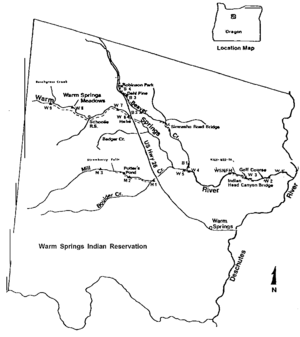
Map of the Warm Springs River basin
|
|
| Country | United States |
| State | Oregon |
| County | Wasco |
| Physical characteristics | |
| Main source | Cascade Range north of Olallie Butte 4,069 ft (1,240 m) 44°57′39″N 121°47′21″W / 44.96083°N 121.78917°W |
| River mouth | Deschutes River 1,240 ft (380 m) 44°51′28″N 121°04′09″W / 44.85778°N 121.06917°W |
| Length | 50 mi (80 km) |
| Basin features | |
| Basin size | 526 sq mi (1,360 km2) |
The Warm Springs River is a river in Oregon, a state in the United States. It's like a smaller stream that flows into a bigger river. This river is a "tributary" of the Deschutes River. It flows through north-central Oregon, generally heading southeast.
About the Warm Springs River
The Warm Springs River starts high up in the Cascade Range mountains. It flows for about 50 miles (80 kilometers). The river's journey ends when it joins the Deschutes River. This meeting point is about 83.7 miles (134.7 km) upstream from where the Deschutes River itself flows into the Columbia River.
Where Does the River Flow?
The river's path is mostly eastward. Sometimes it turns a bit southeast or northeast. Its starting point, called the headwaters, is very close to the border between Wasco County and Clackamas County. This border follows the top of the Cascade mountains.
The area of land that drains water into the Warm Springs River is called its watershed. This watershed is located between Mount Jefferson and Timothy Lake. Parts of the Warm Springs Indian Reservation also follow the edges of this watershed.
Smaller Streams Joining the River
Many smaller streams and creeks flow into the Warm Springs River. These are also called tributaries. As you follow the Warm Springs River from its start to its end, you'll find these streams joining it:
- Dry Creek
- Bunchgrass Creek
- South Fork Warm Springs River
- Badger Creek
- Mill Creek
- Beaver Creek
 | Sharif Bey |
 | Hale Woodruff |
 | Richmond Barthé |
 | Purvis Young |


