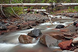
Whychus Creek facts for kids
Quick facts for kids Whychus Creek |
|
|---|---|
 |
|
|
Location of the mouth of Whychus Creek in Oregon
|
|
| Country | United States |
| State | Oregon |
| County | Deschutes and Jefferson |
| Physical characteristics | |
| Main source | Broken Top, Cascade Range Deschutes National Forest, Deschutes County 7,617 ft (2,322 m) 44°05′21″N 121°41′36″W / 44.08917°N 121.69333°W |
| River mouth | Deschutes River Crooked River National Grassland, Jefferson County 2,110 ft (640 m) 44°27′35″N 121°20′07″W / 44.45972°N 121.33528°W |
| Basin features | |
| Basin size | 253 sq mi (660 km2) |
| Type: | Wild, Scenic |
| Designated: | October 28, 1988 |
Whychus Creek is a stream in Oregon, a state in the United States. It flows into the Deschutes River. This creek runs through Deschutes and Jefferson counties.
The creek was once called Squaw Creek. However, this name was changed in 2006 because it was considered offensive. A surveyor named Robert S. Williamson camped by the creek in 1855. He said its Native American name was Why-chus.
Contents
The Creek's Journey
Whychus Creek starts high up in the mountains. It begins at the bottom of Bend Glacier, which is on a peak called Broken Top. This area is part of the Cascade Range. The creek's starting point is about 7,600 feet (2,300 meters) above sea level.
Flowing Through Wilderness
The creek generally flows north through the beautiful Three Sisters Wilderness. As it travels, the water drops over two amazing waterfalls:
- Upper Chush Falls: Here, the water plunges about 200 feet (60 meters).
- Chush Falls: A bit further downstream, the creek drops another 50 feet (15 meters).
After these waterfalls, other smaller streams join Whychus Creek. Park Creek, South Fork, and North Fork flow into it from the left side. Snow Creek joins from the right side.
Reaching the Valley
The creek then turns and flows northeast. It meets the Whychus Creek Canal, which takes some water away. This water is used to fill McKenzie Canyon Reservoir and help with irrigation for farms.
Whychus Creek then flows past the southeast side of the city of Sisters. It goes under two main roads, U.S. Route 20 and Oregon Route 126. After this, Indian Ford Creek joins Whychus Creek from the left.
Journey to the Deschutes River
The creek continues its journey northeast. It leaves Deschutes County and enters Jefferson County. Here, it flows through the Crooked River National Grassland. Finally, Whychus Creek empties into the Deschutes River. This meeting point is downstream from the city of Redmond. The Deschutes River then flows another 123 miles (198 kilometers) before it joins the Columbia River.
 | Chris Smalls |
 | Fred Hampton |
 | Ralph Abernathy |


