
Plateaus of Yellowstone National Park facts for kids

Yellowstone National Park is famous for its amazing geysers and hot springs, but did you know it also has many large, flat areas called plateaus? These high, flat lands are like giant tables on top of the Earth. In Yellowstone, there are nine special plateaus, all part of the much bigger Yellowstone Plateau. They cover a lot of the park, especially south and west of the tall Gallatin and Absaroka mountain ranges. Four of these plateaus were formed by ancient flows of a special type of lava called rhyolite between 110,000 and 70,000 years ago. Imagine molten rock slowly spreading out to create these huge, flat landscapes!
Contents
- Exploring Yellowstone's Unique Plateaus
- Blacktail Deer Plateau: Easy to Explore
- Buffalo Plateau: Home of the Bison
- Central Plateau: A Natural Divide
- Madison Plateau: Yellowstone's Largest Plateau
- Mirror Plateau: Reflecting Nature's Beauty
- Pitchstone Plateau: A Lava Landscape
- Solfatara Plateau: Steaming Vents and Hot Gases
- Trident Plateau: A Three-Pronged Wonder
- Two Ocean Plateau: Where Waters Divide
- Gallery
- See also
Exploring Yellowstone's Unique Plateaus
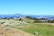
- Gallatin Range as viewed from the Blacktail Deer Plateau

Blacktail Deer Plateau: Easy to Explore
The Blacktail Deer Plateau is one of the easiest plateaus to visit in Yellowstone. You can drive right through it on the Grand Loop Road, which goes from Mammoth to Tower. This plateau gets its name from Blacktail Deer Creek, a stream that flows off its sides. Long before Yellowstone became a national park in 1872, explorers named it because of the many blacktail deer they saw there. It sits at an elevation of 7,113 feet (2,168 m) (about 2,168 meters) and its coordinates are 44°55′28″N 110°34′05″W / 44.92444°N 110.56806°W.
Buffalo Plateau: Home of the Bison
The Buffalo Plateau is located in the northern part of Yellowstone, right where Montana and Wyoming meet! It's north of the Lamar Valley and west of Slough Creek. This plateau was named in 1870 by early explorers who saw huge herds of buffalo roaming across it. Today, you can still find these magnificent animals here. The plateau is quite high, at 8,251 feet (2,515 m) (about 2,515 meters), and its coordinates are 44°59′47″N 110°14′46″W / 44.99639°N 110.24611°W. You can explore parts of it using the Buffalo Plateau trail or the Buffalo Fork Trail.
Central Plateau: A Natural Divide
The Central Plateau acts like a natural wall, separating different parts of the park. To its east, you'll find the beautiful Hayden Valley and the Yellowstone River. To its west, it separates the Lower Geyser Basin and the Madison River. This plateau is at an elevation of 8,399 feet (2,560 m) (about 2,560 meters) and its coordinates are 44°35′49″N 110°37′44″W / 44.59694°N 110.62889°W. It plays an important role in how water flows through the park.
Madison Plateau: Yellowstone's Largest Plateau
The Madison Plateau is the biggest of all the named plateaus in Yellowstone! It stretches south from the Madison River all the way to the Continental Divide and west to the park's border. You'll find it west of the famous Upper and Lower Geyser Basins. This plateau is quite wild and hard to reach, with only one main trail, the Summit Lake Trail, crossing it from east to west. Another trail, the Fairy Creek Trail, touches its eastern edge on its way to Fairy Falls. The Madison Plateau reaches 8,435 feet (2,571 m) (about 2,571 meters) high, and its coordinates are 44°21′02″N 110°58′18″W / 44.35056°N 110.97167°W.
Mirror Plateau: Reflecting Nature's Beauty
The Mirror Plateau is a remote and peaceful area located west of the upper Lamar River. It's where Pelican Creek, which flows into Yellowstone Lake, begins. This plateau gets its name from Mirror Lake, a beautiful lake known for perfectly reflecting the trees and sky around it. Originally, this lake was called Divide Lake because it separated the Lamar and Pelican Creek water systems. In 1878, during a geological survey, Ferdinand V. Hayden officially named it Mirror Lake. The plateau is high up at 8,714 feet (2,656 m) (about 2,656 meters), and its coordinates are 44°43′55″N 110°07′32″W / 44.73194°N 110.12556°W.

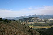
Pitchstone Plateau: A Lava Landscape
The Pitchstone Plateau is found in the southwest corner of Yellowstone National Park. It's named after a type of volcanic glass called pitchstone, which is a dark, glassy lava. This plateau was formed about 70,000 years ago when rhyolite lava flowed across the land. It's located in the areas where the Bechler and Fall River begin. The Pitchstone Plateau is one of the highest, reaching 8,881 feet (2,707 m) (about 2,707 meters), and its coordinates are 44°15′11″N 110°46′24″W / 44.25306°N 110.77333°W.
Solfatara Plateau: Steaming Vents and Hot Gases
The Solfatara Plateau is a smaller plateau located near the beginning of the Gibbon River. It's just west of Canyon Village and south of Grebe Lake. This plateau was named in 1883 by a geologist named Walter Weed. He named it after a solfatara, which is a special kind of thermal vent that releases steam, hydrogen sulfide (a gas that smells like rotten eggs!), and other gases from deep within the Earth. The plateau is bordered by the Norris-Canyon road to the south and trails like Wolf Lake-Cascade Lake to the north. The Grebe Lake trail also crosses its center. It sits at 8,166 feet (2,489 m) (about 2,489 meters) high, with coordinates 44°43′53″N 110°32′45″W / 44.73139°N 110.54583°W.
Trident Plateau: A Three-Pronged Wonder
The Trident Plateau is a small, very remote plateau in the southeast corner of Yellowstone. It's located where the Yellowstone River begins, just east of a mountain formation called "The Trident". This plateau even extends east into the Teton National Forest in Wyoming. Geologist Arnold Hague named "The Trident" in 1885 because its peaks looked like a three-pronged spear, or trident. The Trident Plateau is the highest of all, reaching an impressive 10,649 feet (3,246 m) (about 3,246 meters)! Its coordinates are 44°11′36″N 110°00′40″W / 44.19333°N 110.01111°W.
Two Ocean Plateau: Where Waters Divide
The Two Ocean Plateau gets its fascinating name because the Continental Divide crosses right over it! This means that rain or snow that falls on this plateau can end up in two completely different oceans. Water flowing from one side of the divide will eventually reach the Pacific Ocean, while water from the other side will flow into the Gulf of Mexico (part of the Atlantic Ocean). There's even a special creek here that splits at a place called the Parting of the Waters, sending its water in two directions! This plateau is 9,478 feet (2,889 m) (about 2,889 meters) high, and its coordinates are 44°10′33″N 110°12′59″W / 44.17583°N 110.21639°W.
Gallery
- Plateaus of Yellowstone National Park
-
Blacktail Plateau
-
Pitchstone Plateau


See also
- Mountains and mountain ranges of Yellowstone National Park
