
Lake Chelan facts for kids
Quick facts for kids Lake Chelan |
|
|---|---|

Lake Chelan with Stehekin on the lower left
|
|

Lake Chelan
Location in Washington (state)
|
|
| Location | Chelan County, Washington, United States |
| Coordinates | 47°50′28″N 120°02′47″W / 47.84111°N 120.04639°W |
| Type | Lake |
| Primary inflows | Stehekin River, Railroad Creek |
| Primary outflows | Chelan River |
| Catchment area | 924 sq mi (2,390 km2) |
| Basin countries | United States |
| Max. length | 50.5 mi (81.3 km) |
| Surface area | 52.1 sq mi (135 km2) |
| Average depth | 474 ft (144 m) |
| Max. depth | 1,486 ft (453 m) |
| Water volume | 15,800,000 acre-feet (19,500 GL) |
| Residence time | 10.6 years |
| Shore length1 | 109.2 mi (175.7 km) |
| Surface elevation | 1,100 ft (340 m) |
| Settlements | see Cities |
| 1 Shore length is not a well-defined measure. | |
Lake Chelan ( shə-LAN) is a long, narrow lake in north-central Washington state, U.S.. It stretches for about 50.5-mile (81.3 km) in Chelan County. Before 1927, it was the biggest natural lake in Washington. After the Lake Chelan Dam was finished in 1927, the lake's water level rose by 21 feet (6.4 m) to its current maximum height of 1,100 feet (340 m). There are two towns at the southern end of the lake and one at the very northern tip. This northern town is a starting point for exploring the North Cascades National Park.
Contents
What's in a Name?
The name Chelan comes from an Indigenous Salish word, "Tsi - Laan." This word means 'Deep Water', which is a perfect name for this lake!
How Water Fills Lake Chelan
Every year, a lot of water flows into Lake Chelan. About 75% of this water comes from two main rivers. The Stehekin River provides most of it, about 65% of all the water. The other important river is Railroad Creek. Many smaller streams, along with rain and snow, also add water to the lake.
Lake Chelan is incredibly deep! It's the third deepest lake in the United States and the 26th deepest in the world. At its deepest point, the bottom of the lake is actually 388 feet (118 m) below sea level. The area of land that drains water into the lake is called its watershed. Lake Chelan's watershed is about 924 square miles (2,390 km2). Most of this land (over 90%) is covered in forests. The rest is the lake itself (5.6%) and some farms (3.5%).
Exploring Lake Chelan's Geography
Lake Chelan's Two Basins
Lake Chelan is made up of two main parts, called basins. The lower basin is named Wapato, and it's shallower and shorter. The upper basin is called Lucerne, and it's much deeper and makes up most of the lake's length. These two basins are separated by a raised area, like an underwater hill, called the narrows. Here, the lake is only 0.35 miles (0.56 km) wide, and the sill comes up to within 122 ft (37 m) of the surface.
These two basins were formed by two different glaciers. First, the Chelan glacier carved out the valley from the Stehekin area. Later, the Okanogan glacier moved into the Chelan Valley. When the Okanogan glacier melted and retreated, it left behind a lot of rock and dirt, which created the sill that separates the two basins.
Wapato Basin: The Shallower Part
The Wapato basin is the shallower part of Lake Chelan. Its deepest point is only 400 feet (120 m). There's about 600 feet (180 m) of glacial dirt and rock under the lake bottom here. This section of the lake is about 12 miles (19 km) long and has an average depth of 190 feet (58 m).
Water stays in the Wapato basin for only about 0.8 years before flowing out. This is much faster than the Lucerne Basin, where water stays for about 10 years.
Lucerne Basin: The Deepest Part
The Lucerne basin is the much larger and deeper part of Lake Chelan. It's about 38 miles (61 km) long and has an average depth of 1,148 feet (350 m). This is where you'll find the lake's maximum depth of 1,486 feet (453 m). The Lucerne basin holds 92% of all the water in Lake Chelan and covers 74% of its surface area. This means the Wapato basin only has 8% of the water and 26% of the surface area.
The upper part of Lake Chelan is surrounded by tall mountains. Because of this, there aren't many beaches along the shoreline. About 50 miles (80 km) of this basin's shoreline is part of National Forests, and 12 miles (19 km) is in National Park lands.
Lake Chelan's Climate
The weather around Lake Chelan changes a lot from one end to the other. The southern end of the lake is in a rain shadow from the Cascade Range, meaning it gets very little rain. For example, the town of Chelan only gets about 11.4 inches (29 cm) of rain and 21.8 inches (55 cm) of snow each year.
However, the northern tip of the lake, near Stehekin, gets much more precipitation. Stehekin averages 35.5 inches (90 cm) of rain and 122.5 inches (311 cm) of snow annually. Even with these differences in rain and snow, the temperatures are quite similar. Both locations usually have highs around 60 °F (16 °C) and lows around 40 °F (4 °C) throughout the year.
| Climate data for Chelan, Washington (south end of lake) | |||||||||||||
|---|---|---|---|---|---|---|---|---|---|---|---|---|---|
| Month | Jan | Feb | Mar | Apr | May | Jun | Jul | Aug | Sep | Oct | Nov | Dec | Year |
| Record high °F (°C) | 62 (17) |
63 (17) |
72 (22) |
88 (31) |
98 (37) |
110 (43) |
106 (41) |
105 (41) |
97 (36) |
88 (31) |
72 (22) |
65 (18) |
110 (43) |
| Mean daily maximum °F (°C) | 33.2 (0.7) |
40.2 (4.6) |
51.0 (10.6) |
61.2 (16.2) |
70.0 (21.1) |
76.6 (24.8) |
85.3 (29.6) |
85.2 (29.6) |
76.1 (24.5) |
61.5 (16.4) |
44.3 (6.8) |
34.0 (1.1) |
60.0 (15.6) |
| Mean daily minimum °F (°C) | 24.3 (−4.3) |
26.8 (−2.9) |
33.6 (0.9) |
41.0 (5.0) |
48.7 (9.3) |
56.0 (13.3) |
62.0 (16.7) |
60.9 (16.1) |
52.1 (11.2) |
41.7 (5.4) |
32.0 (0.0) |
25.9 (−3.4) |
42.2 (5.7) |
| Record low °F (°C) | −14 (−26) |
−11 (−24) |
4 (−16) |
23 (−5) |
28 (−2) |
33 (1) |
35 (2) |
42 (6) |
26 (−3) |
15 (−9) |
−3 (−19) |
−18 (−28) |
−18 (−28) |
| Average precipitation inches (mm) | 1.61 (41) |
1.35 (34) |
0.81 (21) |
0.66 (17) |
1.01 (26) |
0.85 (22) |
0.40 (10) |
0.31 (7.9) |
0.28 (7.1) |
0.83 (21) |
1.37 (35) |
1.92 (49) |
11.4 (291) |
| Average snowfall inches (cm) | 7.1 (18) |
3.2 (8.1) |
0.8 (2.0) |
0 (0) |
0 (0) |
0 (0) |
0 (0) |
0 (0) |
0 (0) |
0 (0) |
1.7 (4.3) |
9.0 (23) |
21.8 (55.4) |
| Source: NOAA | |||||||||||||
| Climate data for Stehekin, Washington (north end of lake) | |||||||||||||
|---|---|---|---|---|---|---|---|---|---|---|---|---|---|
| Month | Jan | Feb | Mar | Apr | May | Jun | Jul | Aug | Sep | Oct | Nov | Dec | Year |
| Record high °F (°C) | 55 (13) |
59 (15) |
70 (21) |
88 (31) |
101 (38) |
103 (39) |
107 (42) |
105 (41) |
98 (37) |
84 (29) |
67 (19) |
62 (17) |
107 (42) |
| Mean daily maximum °F (°C) | 33.5 (0.8) |
38.7 (3.7) |
47.7 (8.7) |
58.8 (14.9) |
68.7 (20.4) |
75.7 (24.3) |
85.3 (29.6) |
84.2 (29.0) |
74.1 (23.4) |
57.5 (14.2) |
41.2 (5.1) |
33.1 (0.6) |
58.0 (14.4) |
| Mean daily minimum °F (°C) | 18.6 (−7.4) |
21.7 (−5.7) |
30.4 (−0.9) |
38.0 (3.3) |
44.1 (6.7) |
51.2 (10.7) |
58.7 (14.8) |
58.1 (14.5) |
50.5 (10.3) |
36.4 (2.4) |
26.8 (−2.9) |
19.3 (−7.1) |
37.8 (3.2) |
| Record low °F (°C) | −18 (−28) |
−16 (−27) |
−5 (−21) |
19 (−7) |
25 (−4) |
30 (−1) |
36 (2) |
30 (−1) |
22 (−6) |
15 (−9) |
0 (−18) |
−11 (−24) |
−18 (−28) |
| Average precipitation inches (mm) | 6.43 (163) |
3.67 (93) |
2.98 (76) |
1.63 (41) |
1.13 (29) |
0.79 (20) |
0.55 (14) |
0.63 (16) |
0.98 (25) |
3.46 (88) |
6.80 (173) |
6.45 (164) |
35.5 (902) |
| Average snowfall inches (cm) | 41.3 (105) |
19.7 (50) |
8.4 (21) |
0.2 (0.51) |
0 (0) |
0 (0) |
0 (0) |
0 (0) |
0 (0) |
0.0 (0.0) |
10.9 (28) |
42.0 (107) |
122.5 (311.51) |
| Source: NOAA | |||||||||||||
Towns and Communities Around the Lake
Because Lake Chelan is quite isolated, especially at its northern end, not many people live right along its shores. Chelan is the only official city on the lake. It's at the southern end, near the Lake Chelan Dam and where the Chelan River flows out. In 2010, about 3,918 people lived there.
Another community at the southern end is Manson, which had about 1,418 residents in 2010. At the very northern end of the lake, where the Stehekin River flows in, is the small community of Stehekin, with about 75 residents. There's also a tiny community called Lucerne, with private cabins, located where Railroad Creek enters the lake. Lucerne is also the main way to get to Holden Village, a special retreat center located 11 miles inland from the lake.
Fun Things to Do at Lake Chelan
Fishing in Lake Chelan
Fishing is a very popular activity on Lake Chelan! Many different types of fish live here. Some fish are native, meaning they've always been here:
- Bull trout
- Westslope cutthroat trout
- Largescale sucker
- Longnose sucker
- Bridgelip sucker
- Northern pikeminnow
- Peamouth
- Redside shiner
- Mountain whitefish
- Pygmy whitefish
Over the years, six other types of fish have been introduced to the lake, mostly for sport fishing:
State Fishing Records
In 2013, a huge 35.63-pound (16.16 kg) Lake trout was caught in Lake Chelan. This fish set a new state record for its size!
Protected Areas Around the Lake
There are many beautiful protected lands around Lake Chelan. At the northern end, surrounding Stehekin, is the Lake Chelan National Recreation Area. Much of the lake's shoreline is also part of the Wenatchee National Forest.
At the southern end, near the city of Chelan, you'll find two state parks: Twenty-Five Mile Creek State Park and Lake Chelan State Park. Stehekin is not just a gateway to the Lake Chelan National Recreation Area, but also to the larger North Cascades National Park Complex and other wilderness areas. A large portion (about 87%) of the land in Lake Chelan's watershed is owned by federal, state, or local governments, helping to protect its natural beauty.
Gallery
-
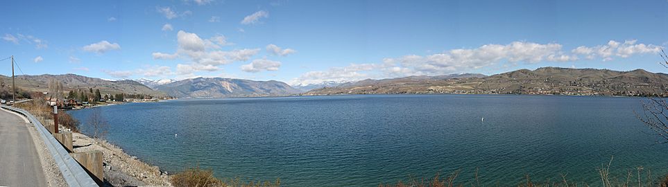
Lake Chelan as seen from the southern shore off U.S. Highway 97
-
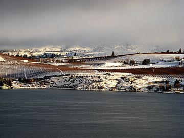
View of Manson orchards from the south shore of Lake Chelan
-
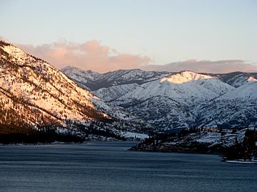
View uplake from the south shore of Lake Chelan
-
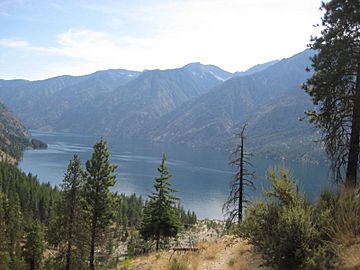
View of Lake Chelan from Lakeshore trail, near Stehekin
-
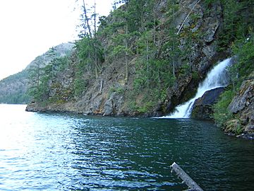
Domke Falls is the best known waterfall that drops into the lake


See also
 In Spanish: Lago Chelan para niños
