Stehekin, Washington facts for kids
Quick facts for kids
Stehekin
|
|
|---|---|

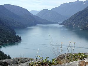
View of Stehekin and the north end of Lake Chelan.
|
|
| Country | United States |
| State | Washington |
| County | Chelan |
| Population
(2007)
|
|
| • Total | 112 (estimated) |
| Time zone | UTC-8 (Pacific (PST)) |
| • Summer (DST) | UTC-7 (PDT) |
| ZIP code |
98852
|
| Area code(s) | 509 |
Stehekin is a small community in Chelan County, Washington. It's not officially a city or town. The name "Stehekin" comes from an old Native American language. It means "the way through."
Stehekin has about 100 people who live there all year. But in the summer, many more people visit for vacations. It also gets busy with seasonal workers.
This community is at the very top (northwest end) of Lake Chelan. It's just south of the North Cascades National Park. Stehekin is part of the Lake Chelan National Recreation Area. This area is managed by the National Park Service. The Glacier Peak Wilderness Area is also nearby, to the northwest.
Contents
Stehekin's Past
The area at the end of Lake Chelan was a very important path for Native Americans. For at least 9,000 years, they used it to travel between communities. These communities were on different sides of the Cascade Range mountains.
In the 1800s, Native Americans called the mountain pass "Stehekin." This meant "the way through." They would keep their canoes at the head of the lake. Around 1875, people from other countries started to settle here. They were looking for valuable minerals in the Stehekin Valley.
More mining started in the 1880s. Many important minerals were found until 1891. There was even a small "gold rush" in the area.
Getting Around Stehekin
It was hard for miners to get their minerals to markets. This was because it was very difficult to reach Stehekin. People suggested building roads and railroads. Later, they thought about highways. But none of these plans ever happened.
Because of this, Stehekin is still not connected to the main roads or train lines. A road was built in the 1890s. It connected the old boat dock to the mining areas. But this road was soon left behind. A new dock was built on the other side of the river.
In 1889, a man named William Buzzard started a farm. He cleared about 160 acres of land. He planted a small garden there. In 1911, the Buckner family bought this land. They made it into a bigger farm and orchard. They worked the farm until the 1940s. A post office opened in Stehekin in 1892.
The Stehekin Valley Road was once a state highway. This was in the first half of the 1900s. Later, it became a county road. Now, the federal government manages it. The road was last made longer in 1949. After that, mining companies stopped trying to extend it. It was too expensive to build and keep up. Parts of the road were washed away by floods in 1995 and 2003.
Fun Things to Do in Stehekin
Stehekin is a popular place for visitors. Hikers and bikers come in the summer. In winter, people enjoy snowshoeing and skiing. Photographers visit all year round.
There are many cool places to see in Stehekin:
- The Buckner Homestead Historic District: This is an old farm with a lot of history.
- The Golden West Visitor Center: A great place to learn about the area.
- The Stehekin Pastry Company: A yummy stop for treats!
- The one-room Stehekin School: A peek into how school used to be.
- Rainbow Falls: A beautiful waterfall that is 312 feet tall.
- Harlequin Bridge.
- The National Park Service cabin at High Bridge: Built by the Civilian Conservation Corps (CCC).
Fishing is also popular in Stehekin. You can try to catch trout and sockeye salmon.
How to Get to Stehekin
There are no roads that connect Stehekin to the rest of the world. But there are about 10 miles of roads within the Stehekin Valley itself.
You can reach Stehekin in a few ways:
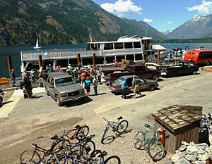
- By passenger ferries: These boats are run by the Lake Chelan Boat Company.
- By private boat: You can boat from Chelan.
- By foot: You can hike over Cascade Pass.
- By floatplane: These planes land on the water.
- By small aircraft: There's a grass airstrip open from June to September.
If people need to bring vehicles to Stehekin, they are carried on a large boat (a barge) across Lake Chelan. The Stehekin Airport is known for being a tricky place to land. It's only 1,230 feet high, but there are mountains on the sides. Trees are at both ends of the 2,630-foot runway. The airport is sometimes closed to the public. This happens when it's used as a base for fighting wildfires.
Many visitors also come to Stehekin by horseback or by hiking. In 2003, a big part of the Stehekin Valley Road was washed out. This was due to the nearby Stehekin River. So, hiking through Cascade Pass became harder. It added about 10 miles to the already long journey.
You can also reach Stehekin from Washington Pass using the Pacific Crest Trail (PCT). The PCT can also lead you to Stehekin from the Suiattle River Valley. This hike is longer than the one from Washington Pass.
There are also many trails through the mountains east of Stehekin. These trails let you walk from the Methow Valley area. The Chelan Summit trail starts near Grade Creek Road. It offers a continuous path all the way into Stehekin. The Lake Shore Trail also leads into Stehekin from Prince Creek. The Lady of the Lake ferry stops at this trailhead.
Stehekin's Weather
Stehekin has a type of weather called a dry-summer humid continental climate. This means it has warm to hot summers. Winters bring a lot of snow.
Winter temperatures are much colder than on the west side of the Cascade Mountains. But they are still not as cold as places further east. The temperature has ranged from 107°F (42°C) in summer to -18°F (-28°C) in winter.
| Climate data for Stehekin, Washington (1991–2020 normals, extremes since 1906) | |||||||||||||
|---|---|---|---|---|---|---|---|---|---|---|---|---|---|
| Month | Jan | Feb | Mar | Apr | May | Jun | Jul | Aug | Sep | Oct | Nov | Dec | Year |
| Record high °F (°C) | 55 (13) |
59 (15) |
70 (21) |
85 (29) |
101 (38) |
103 (39) |
107 (42) |
105 (41) |
98 (37) |
88 (31) |
67 (19) |
62 (17) |
107 (42) |
| Mean maximum °F (°C) | 42 (6) |
48 (9) |
59 (15) |
74 (23) |
86 (30) |
92 (33) |
99 (37) |
98 (37) |
89 (32) |
72 (22) |
52 (11) |
42 (6) |
100 (38) |
| Mean daily maximum °F (°C) | 32.3 (0.2) |
37.8 (3.2) |
46.5 (8.1) |
57.5 (14.2) |
68.6 (20.3) |
74.4 (23.6) |
84.3 (29.1) |
83.3 (28.5) |
72.5 (22.5) |
55.8 (13.2) |
40.0 (4.4) |
32.3 (0.2) |
57.1 (13.9) |
| Daily mean °F (°C) | 28.5 (−1.9) |
31.9 (−0.1) |
38.1 (3.4) |
46.6 (8.1) |
56.2 (13.4) |
62.2 (16.8) |
70.1 (21.2) |
69.3 (20.7) |
60.2 (15.7) |
46.8 (8.2) |
35.2 (1.8) |
29.0 (−1.7) |
47.8 (8.8) |
| Mean daily minimum °F (°C) | 24.8 (−4.0) |
26.0 (−3.3) |
29.8 (−1.2) |
35.8 (2.1) |
43.8 (6.6) |
49.9 (9.9) |
55.9 (13.3) |
55.2 (12.9) |
47.8 (8.8) |
37.8 (3.2) |
30.4 (−0.9) |
25.6 (−3.6) |
38.6 (3.7) |
| Mean minimum °F (°C) | 12 (−11) |
15 (−9) |
22 (−6) |
28 (−2) |
34 (1) |
41 (5) |
47 (8) |
46 (8) |
38 (3) |
27 (−3) |
21 (−6) |
12 (−11) |
8 (−13) |
| Record low °F (°C) | −18 (−28) |
−16 (−27) |
−5 (−21) |
19 (−7) |
25 (−4) |
28 (−2) |
36 (2) |
30 (−1) |
22 (−6) |
16 (−9) |
0 (−18) |
−11 (−24) |
−18 (−28) |
| Average precipitation inches (mm) | 6.75 (171) |
3.72 (94) |
3.60 (91) |
1.44 (37) |
1.07 (27) |
0.75 (19) |
0.46 (12) |
0.49 (12) |
1.05 (27) |
3.66 (93) |
6.73 (171) |
7.16 (182) |
36.88 (936) |
| Average snowfall inches (cm) | 41.4 (105) |
18.5 (47) |
9.1 (23) |
0.2 (0.51) |
0.0 (0.0) |
0.0 (0.0) |
0.0 (0.0) |
0.0 (0.0) |
0.0 (0.0) |
0.2 (0.51) |
9.7 (25) |
50.6 (129) |
129.7 (330.02) |
| Average extreme snow depth inches (cm) | 36 (91) |
33 (84) |
24 (61) |
6 (15) |
0 (0) |
0 (0) |
0 (0) |
0 (0) |
0 (0) |
0 (0) |
6 (15) |
27 (69) |
41 (100) |
| Average precipitation days (≥ 0.01 in) | 17 | 11 | 11 | 8 | 6 | 6 | 3 | 3 | 6 | 11 | 16 | 16 | 114 |
| Average snowy days (≥ 0.01 in) | 11 | 5 | 3 | 0 | 0 | 0 | 0 | 0 | 0 | 0 | 3 | 11 | 33 |
| Source: NOAA | |||||||||||||
Phone Service
For many years, Stehekin was very isolated. It only had expensive satellite and radio phones. There was no cell phone service.
In 2007, a company called WeavTel started offering regular phone service. This connected Stehekin to the rest of Washington State. Not everyone in Stehekin liked this change. But business owners found it helpful to have normal phone service.
Right now, WeavTel service is mostly in the main village area. But the company wants to expand it. They plan to use underground fiber-optic cables to reach more of the valley. This project was made possible by money from federal and state grants. These grants help bring phone service to rural areas.
See Also
 In Spanish: Stehekin (Washington) para niños
 | Kyle Baker |
 | Joseph Yoakum |
 | Laura Wheeler Waring |
 | Henry Ossawa Tanner |


