
Goat Rocks facts for kids
Quick facts for kids Goat Rocks |
|
|---|---|

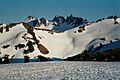
The Goat Rocks, with Gilbert Peak at upper left
|
|
| Highest point | |
| Elevation | 8,201 ft (2,500 m) |
| Geography | |
| Location | Lewis / Yakima counties, Washington, U.S. |
| Parent range | Cascade Range |
| Topo map | USGS Old Snowy Mountain, Walupt Lake |
| Geology | |
| Age of rock | 3.2 million - ~500,000 years |
| Mountain type | Extinct stratovolcano |
| Volcanic arc | Cascade Volcanic Arc |
| Last eruption | ~500,000 years ago |
| Climbing | |
| First ascent | Fred G. Plummer, 1899 |
| Easiest route | Scrambling |
Goat Rocks is an extinct volcano in the Cascade Range in southern Washington, United States. It sits between Mount Rainier and Mount Adams. This volcano is part of the Cascade Volcanoes. It formed when the Juan de Fuca Plate slid under the North American Plate.
Goat Rocks was active from about 3.2 million years ago until 500,000 years ago. At first, it had big, explosive eruptions. Later, it produced a lot of lava flows. The volcano and the area around it are called the Goat Rocks Wilderness. This name comes from the many mountain goats that live there. The wilderness is also home to animals like marmots, pikas, deer, and elk. People can hike and climb in this beautiful area.
Contents
Exploring Goat Rocks: Location and Formation

Goat Rocks volcano is in southern Washington. It is about 113 kilometers (70 miles) west of Yakima. Long ago, Native Americans lived in this area. They hunted, fished, and used the trails for trade.
Goat Rocks is part of the Cascade Volcanoes. This chain of volcanoes formed because the Juan de Fuca Plate is slowly sliding under the North American Plate. This process is called subduction. The plates move about 3 to 4 centimeters (1.2 to 1.6 inches) each year.
.jpg)
The Cascade Volcanoes in Washington are grouped into four main areas. Goat Rocks is in the Mount Adams belt. This area has many volcanoes, mostly made of basaltic andesite lava. The ground under Goat Rocks has older rocks like greywacke and argillite. On top of these are layers of volcanic rocks. These include old lava flows and ash from past eruptions.
Goat Rocks, Mount Adams, Mount Rainier, and Mount St. Helens form a special triangle of volcanoes. Scientists are still trying to understand why this is. It might be linked to a strange area deep in the Earth's crust that has high electrical conductivity.
Goat Rocks is one of the oldest volcanoes in the Cascades. It is about the same size as Mount St. Helens. About 40% of the volcano is made of ash and broken rock. Its old lava flows can be found in the Tieton, Klickitat, and Cispus river valleys. These flows show how big the volcano used to be.
Glaciers and Erosion: Shaping the Landscape
Goat Rocks was once a very tall volcano. But it has changed a lot since it stopped erupting. Over time, glaciers and water have worn away its layers of ash and lava. This process is called erosion. It has uncovered the hard rock where magma used to cool inside the volcano.
The Goat Rocks area has many glaciers, even though it's not super high up. Four main glaciers cover the northern and northeastern slopes. These are the Conrad Glacier, McCall Glacier, Meade Glacier, and Packwood Glacier. There are also many smaller patches of snow that stay all year.
.jpg)
Major Peaks in the Goat Rocks Area
The height of the land in the Goat Rocks area changes a lot. It goes from about 914 meters (3,000 feet) to 2,500 meters (8,201 feet) at its highest point, Gilbert Peak. Because of all the glaciers and erosion, the peaks around Goat Rocks are not as tall as they once were.
| Gilbert Peak (Mount Curtis Gilbert) | 2500 m (8201 ft) |
| Old Snowy Mountain | 2402 m (7881 ft) |
| Ives Peak | 2414 m (7920 ft) |
| Tieton Peak | 2369 m (7772 ft) |
| Johnson Peak | 2282 m (7487 ft) |
| Bear Creek Mountain | 2238 m (7343 ft) |
| Hogback Mountain | 2071 m (6795 ft) |
Eruptions: A Look at Goat Rocks' Past

Goat Rocks is a stratovolcano with a long and interesting history of eruptions. It first became active about 3.2 million years ago. At that time, it had big, explosive eruptions. These eruptions shot out light-colored, rocky lava. One of these events left a layer of ash 650 meters (2,130 feet) thick.
About 3 million years ago, Goat Rocks started erupting darker, heavier lava. As time went on, the lava flows became more like andesite. These flows built up the main part of the volcano between 2.5 and 0.5 million years ago. The volcano might have looked like Mount Rainier does today.
Around 1 million years ago, Goat Rocks produced an amazing lava flow. This flow stretched 80 kilometers (50 miles) down the Naches and Tieton Rivers. It is known as the longest andesite lava flow on Earth. Even as the volcano was wearing away, it kept erupting.
Old Snowy Mountain might have been another vent for Goat Rocks. Or it could be its own volcano. It also had lava flows that were later covered by glaciers. Hogback Mountain, a shield volcano to the north, was also a part of the Goat Rocks volcanic system. It erupted dark lava flows for a long time.
Goat Rocks is now an extinct volcano. This means it has not erupted in a very long time. Its last eruptions were during the Pleistocene epoch, which ended about 11,700 years ago.
Goat Rocks Wilderness: Nature and Fun

The land around Goat Rocks has been protected for a long time. In 1964, the United States Congress created the Goat Rocks Wilderness. This area is now managed by the United States Forest Service. It covers about 43,745 hectares (108,096 acres). It sits between Mount Rainier and Mount Adams.
The wilderness area has different elevations, from 914 meters (3,000 feet) to 2,500 meters (8,201 feet). You can find alpine tundras, glaciers, and small lakes here. There are also 15 different trails, totaling 193 kilometers (120 miles). One of these trails is the highest part of the famous Pacific Crest Trail in Washington. This section runs for 50 kilometers (31 miles) through the middle of the wilderness. Because it's so high up, hikers need to be ready for sudden, strong storms. Much of the wilderness is above the treeline, offering amazing views.
Climate and Wildlife in the Wilderness
The weather in the Goat Rocks Wilderness can change a lot. The Cascade Mountains act like a wall for weather. Wet storms from the west hit the mountains and are forced to rise. As the air rises, it cools and drops its moisture. This causes a lot of rain (up to 381 centimeters or 150 inches each year) on the western side of the mountains. This is why there are so many forests there.
Snowfall is usually more than 8 meters (26 feet) each year. Snow can stay on the ground until July or August. In warmer months, melted snow fills the lakes. Even in summer, snowstorms and freezing temperatures can happen. Strong winds, fog, snow, and rain can make hiking very difficult.
On the eastern side of the mountains, the air drops and warms up. This creates dry winds called Chinook winds. This side gets much less rain and has fewer forests. Temperatures on the western side are more stable, while on the eastern side, they can change quickly.
The Goat Rocks area is named for its many mountain goats. You can often see them around the peaks. Other animals that live at high elevations include marmots and pikas. Below the treeline, you might spot deer and elk. This includes mule deer and Roosevelt elk. Some Rocky Mountain elk were brought here from Yellowstone National Park in 1913.
Climbing and Fun Activities
Old Snowy Mountain and Gilbert Peak are two popular peaks for hikers and mountaineers. Both are a bit remote, but Old Snowy Mountain is easier to reach and climb. This makes it more popular. There are several ways to climb Old Snowy Mountain. It usually takes 5–6 hours and involves climbing 1,097 meters (3,600 feet) in elevation. The round trip is about 23 kilometers (14 miles). You can hike or scramble up it, and there's also a trail. From the top, you can see Mount St. Helens and Mount Rainier far away. Be careful, though, as there can be loose rocks and a risk of avalanches.
The first person to climb Gilbert Peak was Fred G. Plummer in 1899. This climb also involves going up 1,097 meters (3,600 feet). It takes 6–8 hours and is about 26 kilometers (16 miles) round trip. Climbing Gilbert Peak is harder than Old Snowy Mountain because the routes are longer and have more loose rock. Most climbers try to climb Gilbert early in the season when there is less snow.
The Forest Service allows many fun activities in the Wilderness. These include day hiking, horse riding, and backpacking. Because Goat Rocks is a protected wilderness area, motor vehicles are not allowed. This means no bicycles, wagons, motorboats, or helicopters. You need a free permit to enter the wilderness.
Images for kids
-
The Goat Rocks, with Gilbert Peak at upper left
