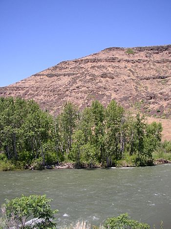
Naches River facts for kids
Quick facts for kids Naches River |
|
|---|---|
 |
|
| Country | United States |
| State | Washington |
| Region | Yakima County, Kittitas County |
| Cities | Naches, Yakima |
| Physical characteristics | |
| Main source | Middle Fork Little Naches River Naches Pass 5,860 ft (1,790 m) 47°1′52″N 121°23′59″W / 47.03111°N 121.39972°W |
| River mouth | Yakima River Yakima 1,079 ft (329 m) 46°37′50″N 120°30′52″W / 46.63056°N 120.51444°W |
| Length | 75 mi (121 km) |
| Basin features | |
| Tributaries |
|
The Naches River is a cool river in central Washington, United States. It's like a smaller river that flows into a bigger one, which is called a tributary. The Naches River flows into the Yakima River.
This river starts as the Little Naches River. It's about 75 miles (121 km) long. When the Little Naches River meets another river called the Bumping River, it officially becomes the Naches River. The Naches River and its smaller streams drain water from the eastern side of the Cascade Range. This area is east of Mount Rainier and northeast of Mount Adams. The Naches River actually carries the most water into the Yakima River!
The upper parts of the Naches River basin have rugged mountains and wild areas. But further down, the Naches River and its friend, the Tieton River, flow through valleys. These valleys have towns and lots of fruit orchards, especially near Yakima. Long ago, the river was a key path for people traveling between the east and west sides of the Cascades. Both Native Americans and early settlers used Naches Pass to cross.
The name "Naches" comes from Native American words. "Naugh" means rough or turbulent, and "chez" means water. So, it means "rough water."
Contents
Journey of the Naches River
The Naches River has an interesting journey! It starts high up in the mountains.
Where the River Begins
The Little Naches River starts with several small streams. These streams are found near Naches Pass. This area is where four different counties meet: Yakima, Kittitas, Pierce, and King. Most of the Naches River area is in Yakima County.
The Little Naches River begins where its North Fork and Middle Fork join together. It flows southeast for about 20 miles (32 km). Then, it meets the Bumping River. This is where it officially becomes the Naches River. The area around the Little Naches River includes part of the Norse Peak Wilderness. This wilderness is northeast of Mount Rainier.
The Bumping and American Rivers
The Bumping River also starts high up. Its source is near Mount Rainier National Park. This river flows northeast into Bumping Lake. This lake is natural, but a dam makes it bigger. Below the dam, the Bumping River continues northeast. It meets its main tributary, the American River, just before joining the Little Naches River.
The American River starts from several streams near Chinook Pass. This pass is on the eastern edge of Mount Rainier National Park. For most of its path, the American River flows next to State Route 410. This road crosses the Cascades at Chinook Pass.
Flowing Through Valleys
After the Little Naches and Bumping rivers meet, the Naches River flows southeast. It goes through the Nile Valley. Here, it picks up smaller streams like Nile Creek and Rattlesnake Creek. Next, the river enters the Naches Valley. This is where it meets its biggest tributary, the Tieton River.
The Naches Valley is home to the towns of Naches and Tieton. This valley is famous for its many fruit orchards, especially apples. Farmers use water from both the Tieton and Naches rivers to irrigate their crops.
The Tieton River starts at Rimrock Lake. This is a man-made lake, or reservoir. Several streams from the Goat Rocks Wilderness feed into Rimrock Lake. The William O. Douglas Wilderness is also part of the Naches River area.
Finally, after the Tieton River joins, the Naches River collects Cowiche Creek. It then flows east along the north side of the city of Yakima. This is where the Naches River proudly joins the larger Yakima River.
Fun and Recreation
The Naches River basin is a great place for outdoor fun! Much of this area is covered by national forests and wilderness lands.
- You can find parts of Wenatchee National Forest, Mount Baker-Snoqualmie National Forest, and Gifford Pinchot National Forest.
- There are also parts of the Norse Peak Wilderness, William O. Douglas Wilderness, and Goat Rocks Wilderness. These are wild, protected areas.
The Pacific Crest Trail is a famous long-distance hiking trail. It follows the high mountain ridges of the Cascades. This trail goes along the headwaters of many streams in the Naches River basin.
If you love to ski, the White Pass Ski Area is located near White Pass. This is close to where the Tieton River begins. It's a popular spot for winter sports!
 | Delilah Pierce |
 | Gordon Parks |
 | Augusta Savage |
 | Charles Ethan Porter |

