
American Falls Dam facts for kids
Quick facts for kids American Falls Dam |
|
|---|---|

Aerial view of the dam
|
|
| Official name | American Falls Dam |
| Location | Power County, Idaho, U.S. |
| Coordinates | 42°46′51″N 112°52′32″W / 42.78083°N 112.87556°W |
| Construction began | 1976 |
| Opening date | 1978 |
| Operator(s) | United States Bureau of Reclamation |
| Dam and spillways | |
| Impounds | Snake River |
| Height | 94 ft (29 m) |
| Length | 5,277 ft (1,608 m) |
| Width (base) | 42.5 ft (13.0 m) |
| Reservoir | |
| Creates | American Falls Reservoir |
| Total capacity | 1,671,300 acre⋅ft (2.0615 km3) |
| Normal elevation | 4,354 ft (1,327 m) AMSL |
| Power station | |
| Operator(s) | Idaho Power Company |
| Turbines | 3 |
| Installed capacity | 112 MW |
The American Falls Dam is a large concrete dam built across the Snake River in Idaho, U.S.. It's located near the town of American Falls. This important dam and its huge lake, called the American Falls Reservoir, help control floods, provide water for farms, and offer fun places for people to visit. When the first dam was built, people living in American Falls had to move a big part of their town to make space for the new lake. The dam you see today was finished in 1978, replacing the older one.
Contents
How the Land Was Formed
Long, long ago, over a million years ago, lava flows created a natural dam in this area. This dam formed a wide, shallow lake. Over time, this lake filled up with fine sand, silt, and gravel. Eventually, the natural lava dam broke, and the lake drained away.
Later, the Snake River was blocked again by more basalt (volcanic rock) flows. One of these lava dams, a few miles downstream from where the American Falls Dam is now, created another lake. This lake was so deep that over 80 feet (24 m) of clay, silt, and sand settled at the bottom. These events happened less than a million years ago. The Snake River has kept carving its path through the rock and sediments ever since.
The River's Location
The American Falls Dam is built on the Snake River Plain. The land around the river is gently rolling, meaning it has small hills and valleys. The original American Falls was a place where the river narrowed to about 600 ft (180 m). Here, the water would cascade down about 50 ft (15 m) in several smaller drops, each about 6–10 ft high. The very last drop was a plunge of about 15 ft (4.6 m).
History of the Dam
Early Days and First Plans (1880–1925)
The town of American Falls was first mapped out in the early 1880s. It got its name from the waterfalls on the Snake River nearby. In the late 1800s, private companies started building canals to bring water to farms in southern Idaho. This helped the farming industry grow.
A law called the Newlands Reclamation Act was passed in 1902. This law made federal money available to build and maintain irrigation projects in the Western United States. In 1902, the first power plant was built on the falls. It was later bought by the Idaho Power Company in 1916. Building dams became the best way to control the large amounts of water in western rivers. The lakes behind the dams could then provide water for farms all year round.
In 1923, the government needed to buy the land where the original town of American Falls was located. This was to make space for the new reservoir. This led to some legal disagreements about how much the properties were worth.
Building the First Dam (1925–1960)
The construction of the first dam at American Falls began in 1925. It was completed by the Bureau of Reclamation in 1927. The river was temporarily held back while the new concrete dam was built. The railroad bridge over the river also had to be raised so trains could cross the new, larger lake.
The New Dam and Challenges (1960–1978)
The dam you see today is actually the second one built here. In the early 1960s, tests on the concrete of the first dam showed it was wearing out. Chemicals in the concrete were reacting and making it weaker. So, the decision was made to replace it.
A new dam was built downstream and finished in 1978. In 1976, the Idaho Power Company built the dam's current power plant. This plant has three generators that can produce 112,420 kilowatts (112 MW) of hydroelectricity (power from water).
In 1976, another dam upstream called the Teton Dam broke while it was being filled. This caused a huge flood of melting snow to rush down the Teton River, which flows into the Snake River. Several towns were destroyed. To try and control this flood, water was released from American Falls Dam as fast as possible. The American Falls reservoir filled up, but it did not overflow.
When the second dam was being planned, some groups were against making the reservoir bigger. This included members of the Shoshone and Bannock communities. They had lived in this area for thousands of years, and the land was very important to them. Many scientists also opposed the expansion because it would mean losing natural habitats and access to old fossils.
Images for kids
-
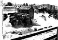
American Falls (circa 1902)
-
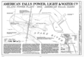
Plans for Power House on American Falls (1902)
-
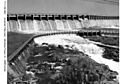
American Falls Dam (1947)


