Teton River (Idaho) facts for kids
The Teton River is a river in southeastern Idaho, United States. It's about 81.5 miles (131.2 km) long and flows into the Henrys Fork, which is part of the larger Snake River system. The Teton River gets its water from the Teton Valley, located on the west side of the Teton Range, near the border between Idaho and Wyoming. Because it's on the western side of the Tetons, it receives more rain than many other rivers in the area.
Quick facts for kids Teton River |
|
|---|---|

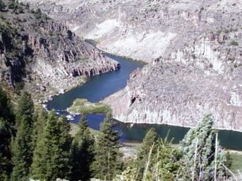
Teton River in the canyons northeast of Rexburg
|
|
|
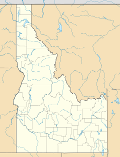
Location of the mouth of the Teton River in Idaho
|
|
| Country | United States |
| State | Idaho |
| Physical characteristics | |
| Main source | Confluence of Warm and Drake Creeks Near Victor, Teton County 6,027 ft (1,837 m) 43°36′38″N 111°09′16″W / 43.61056°N 111.15444°W |
| River mouth | Henrys Fork Rexburg, Madison County 4,829 ft (1,472 m) 43°53′56″N 111°50′21″W / 43.89889°N 111.83917°W |
| Length | 81.5 mi (131.2 km) |
| Basin features | |
| Basin size | 1,130 sq mi (2,900 km2) |
Contents
River History: What Happened Here?
When Europeans first arrived in the 1820s, the Shoshone and other related tribes lived in this area. The Teton Basin was a great place for the fur trade. This attracted many other tribes, like the Nez Perce, Flathead, and Gros Ventre.
At that time, the basin was part of the Oregon Country, which was claimed by both the United States and Great Britain. Different groups trading furs sometimes had conflicts. In 1832, a trading meeting went wrong, leading to the Battle of Pierre's Hole. This battle was between the Gros Ventre tribe and a group of American trappers, who were helped by their Nez Perce and Flathead allies. It was a short but intense battle.
The Teton Dam Collapse
A very important event happened on the Teton River on June 5, 1976. The Teton Dam, which was an earthen dam in Teton Canyon, broke apart. The huge rush of water destroyed the lower part of the Teton River valley. It washed away the plants and trees along the riverbanks and even changed the canyon walls.
This dam failure caused a lot of damage to the river's environment. The native cutthroat trout fish population was put in danger. The powerful water and too much sediment also harmed the river habitat in the Snake River and some of its smaller streams.
The Teton River's Journey: Where Does It Flow?
The Teton River's watershed, which is the area of land that drains into the river, covers about 1,133 square miles (2,934 km2). Most of this area is in Idaho, with a smaller part in Wyoming.
The main part of the river starts near Victor, Idaho, close to the Wyoming state line. It's formed where Warm Creek and Drake Creek join together. Several other creeks flow down from the surrounding Teton Mountains, Big Hole, and Snake River Range mountains to join the Teton River. Most of the water flowing into the Teton River comes from streams on the western side of the Tetons, such as Trail, Fox, Teton, and South Leigh creeks.
Through the Teton Basin
The river flows north in a slow, winding path through a wide, flat area called the Teton Basin. This area was once known as "Pierre's Hole". The Teton Range is to the east, and the Big Hole Mountains are to the west. A large part of the river's upper section in the Teton Basin is surrounded by many wetlands, which are areas of land covered by water.
Into the Canyon and Beyond
After leaving the north end of the Teton Basin, the Teton River enters a canyon called Teton Canyon. This canyon is about 25 miles (40 km) long and is hard to reach. Here, Badger Creek and Bitch Creek join the Teton River from the east. Then, the river turns sharply west and is joined by Canyon Creek from the south.
After flowing past the site of the failed Teton Dam, the Teton River splits into two branches. One branch is called the South Fork Teton River, and the other is the North Fork Teton River (which is also known as the Teton River itself). The South Teton River flows southwest until it meets Henry's Fork near Rexburg, Idaho. The Teton River (North Fork) continues west and also joins the Henrys Fork near Rexburg.
River Life: Animals and Plants
The upper part of the Teton River, between Victor and Driggs, is very important for restoration efforts. This area has the best places for Yellowstone cutthroat trout (a type of fish) to lay their eggs.
A study by Idaho Fish and Game showed that the number of Yellowstone cutthroat trout has dropped by 95%. At the same time, populations of non-native fish like brook trout and rainbow trout have increased a lot. The Teton River is considered one of the few remaining strongholds for Yellowstone cutthroat trout. These fish now only live in about 27% of their original habitat in the Greater Yellowstone Ecosystem.
Why Fish Populations Change
One main reason for the decline of Yellowstone cutthroat trout is that they have been mixing with non-native rainbow trout. This creates hybrid fish, which are not pure Yellowstone cutthroat trout. Other reasons include competition with non-native brook trout. Also, changes to their habitat from things like water being taken out of the river, grazing by animals, mining, logging, and new buildings have also affected the fish.
 | Anna J. Cooper |
 | Mary McLeod Bethune |
 | Lillie Mae Bradford |


