
Teton County, Idaho facts for kids
Quick facts for kids
Teton County
|
||
|---|---|---|

Teton County Courthouse
|
||
|
||

Location within the U.S. state of Idaho
|
||
 Idaho's location within the U.S. |
||
| Country | ||
| State | ||
| Founded | January 26, 1915 | |
| Named for | The Teton Mountains | |
| Seat | Driggs | |
| Largest city | Victor | |
| Area | ||
| • Total | 451 sq mi (1,170 km2) | |
| • Land | 449 sq mi (1,160 km2) | |
| • Water | 1.1 sq mi (3 km2) 0.2% | |
| Population
(2020)
|
||
| • Total | 11,630 |
|
| • Density | 26/sq mi (10/km2) | |
| Time zone | UTC−7 (Mountain) | |
| • Summer (DST) | UTC−6 (MDT) | |
| Congressional district | 2nd | |

Teton County is a special area in the U.S. state of Idaho. It's like a big neighborhood with its own local government. In 2020, about 11,630 people lived here.
The main town, called the county seat, is Driggs. The biggest town in the county is Victor. Teton County was created in 1915. It got its name from the beautiful Teton Mountains that are located to its east.
Teton County is also part of a larger area called the Jackson, Wyoming-Idaho Micropolitan Statistical Area. This means it's connected to the economy and community around Jackson, WY.
Long ago, in 1808, a person named John Colter found the Teton Valley. He was part of the famous Lewis and Clark Expedition that explored the western United States. This valley later became known as Pierre's Hole. In 1832, a big meeting called the Rendezvous happened here. After that meeting, there was a fight known as the Battle of Pierre's Hole.
Contents
Geography of Teton County
Teton County is located in the eastern part of Idaho. It's known for its beautiful mountains and valleys.
How Big is Teton County?
The U.S. Census Bureau says that Teton County covers about 451 square miles. Most of this area, about 449 square miles, is land. Only a small part, about 1.1 square miles, is water. This makes Teton County the second-smallest county in Idaho by land area.
Neighboring Counties
Teton County shares its borders with a few other counties:
- To the north is Fremont County.
- To the west is Madison County.
- To the south is Bonneville County.
- To the east is Teton County, Wyoming, which is in the state of Wyoming.
Main Roads in Teton County
These are the important roads that help people travel through Teton County:
 State Highway 31
 State Highway 32
 State Highway 33
Protected Natural Areas
Part of the Targhee National Forest is located within Teton County. This is a large forest area protected by the government. It offers many outdoor activities like hiking and camping.
People of Teton County
The number of people living in Teton County has changed a lot over the years.
| Historical population | |||
|---|---|---|---|
| Census | Pop. | %± | |
| 1920 | 3,921 | — | |
| 1930 | 3,573 | −8.9% | |
| 1940 | 3,601 | 0.8% | |
| 1950 | 3,204 | −11.0% | |
| 1960 | 2,639 | −17.6% | |
| 1970 | 2,351 | −10.9% | |
| 1980 | 2,897 | 23.2% | |
| 1990 | 3,439 | 18.7% | |
| 2000 | 5,999 | 74.4% | |
| 2010 | 10,170 | 69.5% | |
| 2020 | 11,630 | 14.4% | |
| 2023 (est.) | 12,549 | 23.4% | |
| U.S. Decennial Census 1790–1960, 1900–1990, 1990–2000, 2010–2020 2020 |
|||
Population in 2010
In 2010, there were 10,170 people living in Teton County. These people lived in 3,651 homes. About 2,509 of these homes were families. The county had about 22.6 people per square mile.
Most of the people in Teton County were white (85.6%). About 11.7% were from other races. About 1.5% were from two or more races. People of Hispanic or Latino origin made up 16.9% of the population.
Many people in Teton County have ancestors from different countries. About 29.9% had English ancestors. About 20.3% had German ancestors. Around 13.0% had Irish ancestors.
The average age of people in Teton County was 33.2 years old. Many homes had children under 18 living with them (39.3%). Most homes (58.9%) were married couples living together.
Education in Teton County
Public schools in Teton County are managed by the Teton County School District 401. This is the only school district in the county.
High School in Driggs
The county's only traditional high school is Teton High School. It is located in the town of Driggs.
College Opportunities
College of Eastern Idaho includes Teton County in its area. This means students from Teton County can attend this college. However, the county does not pay taxes to support the college directly.
Communities in Teton County
Teton County has several towns and smaller communities.
Cities in Teton County
Smaller Communities
These are smaller places in the county that are not officially cities:
- Bates
- Felt
- Clementsville
- Cache
- Darby
Images for kids
-
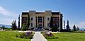
The Teton County Courthouse in Driggs.
See also
 In Spanish: Condado de Teton (Idaho) para niños
