
List of dams in the Colorado River system facts for kids

The Colorado River system is home to many important dams. These dams are found across the southwestern United States and northwestern Mexico. The Colorado River flows for about 1,450 miles (2,333 km). It starts in the Rocky Mountains and ends in the Gulf of California. This river system provides water to parts of seven U.S. states and two Mexican states.
The Colorado River is one of the most developed rivers in the world. It has fifteen dams on its main stream. Hundreds more dams are built on its smaller rivers, called tributaries. Together, these dams can hold four to five times the river's yearly water flow. They help create hydroelectricity (power from water). They also supply water for farming and for over 35 million people to drink and use in their homes and businesses.
Dams on smaller rivers (tributaries) are included in this list if they are taller than 250 feet (76 meters). They are also listed if they can store more than 50,000 acre-feet (61,674,000 cubic meters) of water. Some historically important dams are also listed. These tributary dams are split into two groups: those in the Upper Basin and those in the Lower Basin. The Upper Basin is the half of the Colorado River basin above Lee's Ferry, Arizona. Important rivers in the Upper Basin include the Green, Gunnison, and San Juan. Rivers in the Lower Basin include the Little Colorado, Virgin, and Gila. A river called the Animas River, which flows into the San Juan River, was affected by a mining waste spill in 2015.
Dams serve many purposes:
- Flood control: They hold back floodwaters temporarily and then release them slowly.
- Hydropower: They use the force of flowing water to create electricity.
- Irrigation: They store and provide water for farms to grow crops.
- Municipal: They store and provide water for cities, homes, and businesses.
- Regulation: They help control the river's flow. This makes sure water is released steadily or when needed by people downstream.
Dams on the Main Colorado River
The Colorado River's main channel has several large and important dams. These dams are crucial for managing water resources across the region. They help provide water and power to millions of people.
-
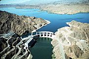
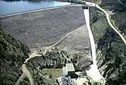
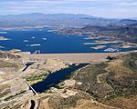
Parker Dam (AZ-CA)
-
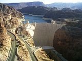
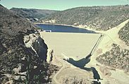
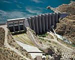
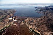
Hoover Dam (AZ-NV)
-
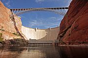
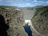
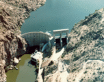
Glen Canyon Dam (AZ)
-
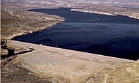
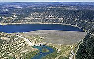
Granby Dam (CO)


| Name | State | Owner | Purpose | Year completed |
Reservoir | Reservoir capacity |
Capacity (MW) |
Annual generation (MWh) |
Refs |
|---|---|---|---|---|---|---|---|---|---|
| Morelos Dam | IBWC | Irrigation | 1950 | N/A | N/A | N/A | N/A | ||
| Laguna Diversion Dam | USBR | Diversion | 1905 | N/A | N/A | N/A | N/A | ||
| Imperial Dam | USBR | Irrigation | 1938 | Imperial Reservoir | 160,000 acre.ft (197,400 dam3) |
N/A | N/A | ||
| Palo Verde Dam | USBR | Diversion | 1958 | N/A | N/A | N/A | N/A | ||
| Headgate Rock Dam | BIA | Irrigation | 1941 | Moovalya Lake | N/A | 19.5 | ? | ||
| Parker Dam | USBR | Hydropower Irrigation Municipal |
1938 | Lake Havasu | 646,200 acre.ft (797,100 dam3) |
120 | 456,944 | ||
| Davis Dam | USBR | Hydropower Regulation |
1951 | Lake Mohave | 1,818,300 acre.ft (2,242,800 dam3) |
255 | 1,147,673 | ||
| Hoover Dam | USBR | Flood control Hydropower Irrigation Municipal Regulation |
1936 | Lake Mead | 28,945,000 acre.ft (35,702,400 dam3) |
2,079 | 3,806,935 | ||
| Glen Canyon Dam | USBR | Hydropower Regulation |
1966 | Lake Powell | 26,214,900 acre.ft (32,334,900 dam3) |
1,296 | 3,454,847 | ||
| Price-Stubb Dam | PCID MCID |
Irrigation | 1911 | N/A | N/A | N/A | N/A | ||
| Grand Valley Diversion Dam | USBR | Irrigation | 1916 | N/A | N/A | 3 | 19,350 | ||
| Windy Gap Dam | Northern Water | Irrigation Municipal |
1970 | Windy Gap Reservoir | 445 acre.ft (549 dam3) |
N/A | N/A | ||
| Granby Dam | USBR | Irrigation Municipal |
1950 | Lake Granby | 539,800 acre.ft (665,800 dam3) |
N/A | N/A | ||
| Shadow Mountain Dam | USBR | Irrigation Municipal |
1946 | Shadow Mountain Lake | 18,400 acre.ft (22,700 dam3) |
N/A | N/A | ||
| Total | 58,343,045 acre.ft (71,963,595 dam3) |
3,772.5 | 8,885,749 | ||||||
Dams in the Upper Colorado River Basin
The Upper Basin of the Colorado River includes the areas above Lee's Ferry in Arizona. This region has many dams on smaller rivers that feed into the main Colorado River. These dams help manage water for different uses, like farming and creating power.
-
Blue Mesa Dam (CO)
-
Fontenelle Dam (WY)
-
Green Mountain Dam (CO)
-
McPhee Dam (CO)
-
Navajo Dam (NM)


| Name | State | Stream | Owner | Purpose | Year completed |
Reservoir | Reservoir capacity |
Capacity (MW) |
Annual generation (MWh) |
Refs |
|---|---|---|---|---|---|---|---|---|---|---|
| Blue Mesa Dam | Gunnison | USBR | Flood control Hydropower Regulation |
1966 | Blue Mesa Reservoir | 940,700 acre.ft (1,160,300 dam3) |
86.4 | 203,412 | ||
| Dillon Dam | Blue | Denver Water | Irrigation Municipal |
1963 | Dillon Reservoir | 257,304 acre.ft (317,373 dam3) |
1.8 | ? | ||
| Flaming Gorge Dam | Green | USBR | Flood control Hydropower Regulation |
1964 | Flaming Gorge Reservoir | 3,788,700 acre.ft (4,673,200 dam3) |
153 | 344,369 | ||
| Fontenelle Dam | Green | USBR | Flood control Irrigation |
1964 | Fontenelle Reservoir | 345,360 acre.ft (426,990 dam3) |
10 | 67,043 | ||
| Green Mountain Dam | Blue | USBR | Hydropower Regulation |
1943 | Green Mountain Reservoir | 153,639 acre.ft (189,507 dam3) |
21.6 | 60,228 | ||
| Joes Valley Dam | Seely Cr. | USBR | Irrigation Municipal |
1966 | Joes Valley Reservoir | 54,920 acre.ft (67,740 dam3) |
N/A | N/A | ||
| McPhee Dam | Dolores | USBR | Flood control Irrigation |
1984 | McPhee Reservoir | 381,195 acre.ft (470,187 dam3) |
1.283 | 5,335 | ||
| Morrow Point Dam | Gunnison | USBR | Hydropower | 1968 | Morrow Point Reservoir | 117,190 acre.ft (144,550 dam3) |
173.334 | 292,887 | ||
| Navajo Dam | San Juan | USBR | Flood control Irrigation Municipal Regulation |
1962 | Navajo Lake | 1,708,600 acre.ft (2,107,500 dam3) |
32 | 215,000 | ||
| Ridges Basin Dam | Offstream | USBR | Irrigation | 2007 | Lake Nighthorse | 120,000 acre.ft (148,000 dam3) |
N/A | N/A | ||
| Ridgway Dam | Uncompahgre | USBR | Flood control Irrigation |
1987 | Ridgway Reservoir | 84,410 acre.ft (104,120 dam3) |
N/A | N/A | ||
| Ruedi Dam | Fryingpan | USBR | Irrigation Municipal |
1968 | Ruedi Reservoir | 102,000 acre.ft (125,800 dam3) |
N/A | N/A | ||
| Scofield Dam | Price | USBR | Irrigation Municipal |
1946 | Scofield Reservoir | 73,600 acre.ft (90,780 dam3) |
N/A | N/A | ||
| Soldier Creek Dam | Strawberry | USBR | Irrigation Municipal |
1974 | Strawberry Reservoir | 1,127,610 acre.ft (1,390,860 dam3) |
N/A | N/A | ||
| Starvation Dam | Strawberry | USBR | Irrigation | 1970 | Starvation Reservoir | 167,300 acre.ft (206,400 dam3) |
N/A | N/A | ||
| Taylor Park Dam | Taylor | USBR | Irrigation | 1937 | Taylor Park Reservoir | 106,200 acre.ft (130,990 dam3) |
N/A | N/A | ||
| Vallecito Dam | Los Pinos River | USBR | Irrigation | 1941 | Vallecito Reservoir | 129,700 acre.ft (160,000 dam3) |
N/A | N/A | ||
| Vega Dam | Plateau Creek | USBR | Irrigation | 1959 | Vega Reservoir | 33,800 acre.ft (41,691 dam3) |
N/A | N/A | ||
| Williams Fork Dam | Williams Fork | Denver Water | Irrigation Municipal |
1959 | Williams Fork Reservoir | 96,822 acre.ft (119,426 dam3) |
3.158 | ? | ||
| Wolford Mountain Dam | Muddy Cr. | CRWCD | Irrigation Municipal |
1996 | Wolford Mountain Reservoir | 66,000 acre.ft (81,400 dam3) |
N/A | N/A | ||
| Total | 9,821,250 acre.ft (12,114,080 dam3) |
482.575 | 1,188,274 | |||||||
Dams in the Lower Colorado River Basin
The Lower Basin of the Colorado River is the area below Lee's Ferry. This part of the river system also has many important dams on its tributaries. These dams play a big role in controlling floods and supplying water for cities and farms in the drier parts of the Southwest.
-
Bartlett Dam (AZ)
-
Mormon Flat Dam (AZ)
-
New Waddell Dam (AZ)
-
Painted Rock Dam (AZ)


| Name | State | Stream | Owner | Purpose | Year completed |
Reservoir | Reservoir capacity |
Capacity (MW) |
Annual generation (MWh) |
Refs |
|---|---|---|---|---|---|---|---|---|---|---|
| Alamo Dam | Bill Williams | USACE | Flood control | 1968 | Alamo Lake | 1,043,000 acre.ft (1,286,500 dam3) |
N/A | N/A | ||
| Bartlett Dam | Verde | USBR | Flood control Irrigation |
1939 | Bartlett Lake | 176,186 acre.ft (217,318 dam3) |
N/A | N/A | ||
| Coolidge Dam | Gila | BIA | Flood control Irrigation |
1930 | San Carlos Lake | 910,000 acre.ft (1,122,400 dam3) |
N/A | N/A | ||
| Horse Mesa Dam | Salt | USBR | Hydropower Regulation |
1927 | Apache Lake | 245,138 acre.ft (302,367 dam3) |
129 | 126,900 | ||
| Horseshoe Dam | Verde | USBR | Flood control Regulation |
1946 | Horseshoe Lake | 131,500 acre.ft (162,200 dam3) |
N/A | N/A | ||
| Mormon Flat Dam | Salt | USBR | Hydropower Regulation |
1925 | Canyon Lake | 57,852 acre.ft (71,358 dam3) |
60 | 65,400 | ||
| New Waddell Dam | Agua Fria | USBR | Irrigation Municipal |
1994 | Lake Pleasant | 1,108,600 acre.ft (1,367,409 dam3) |
45 | ? | ||
| Painted Rock Dam | Gila | USACE | Flood control | 1960 | Painted Rock Reservoir | 2,491,700 acre.ft (3,073,400 dam3) |
N/A | N/A | ||
| Sand Hollow Dam | Offstream | WCWCD | Irrigation Municipal |
2002 | Sand Hollow Reservoir | 51,360 acre.ft (63,350 dam3) |
N/A | N/A | ||
| Stewart Mountain Dam | Salt | USBR | Hydropower Regulation |
1930 | Saguaro Lake | 69,765 acre.ft (86,052 dam3) |
13 | 57,700 | ||
| Theodore Roosevelt Dam | Salt | USBR | Flood control Hydropower Irrigation Municipal |
1911 | Theodore Roosevelt Lake | 2,910,200 acre.ft (3,589,600 dam3) |
36 | 123,900 | ||
| Total | 9,195,301 acre.ft (11,342,000 dam3) |
283 | 373,900 | |||||||
